
Fitxategi:Caucasus-ethnic-1995.jpg

Aurreikuspen honen neurria: 512 × 599 pixel. Bestelako bereizmenak: 205 × 240 pixel | 410 × 480 pixel | 656 × 768 pixel | 875 × 1.024 pixel | 1.749 × 2.048 pixel | 2.606 × 3.051 pixel.
Bereizmen handikoa ((2.606 × 3.051 pixel, fitxategiaren tamaina: 2,46 MB, MIME mota: image/jpeg))
Fitxategi hau Wikimedia Commonsekoa da. Hango deskribapen orriko informazioa behean duzu. |

|
File:Caucasus-ethnic en.svg fitxategi honen bektore bertsioa da. Hau rasterizatutako irudiaren ordez erabili beharko litzateke.
File:Caucasus-ethnic-1995.jpg → File:Caucasus-ethnic en.svg
Grafiko bektorialei buruzko informazioa lortzeko, irakurri SVGra trantsizioa Commonsen. MediaWikiko SVG irudien inguruko laguntza teknikoa ere badago. |
 |

|
Fitxategi hau File:Caucasus-ethnic-2004.jpg-gatik ordezkatua izan da. Beste fitxategia erabiltzea gomendatzen da.
|

|
Laburpena
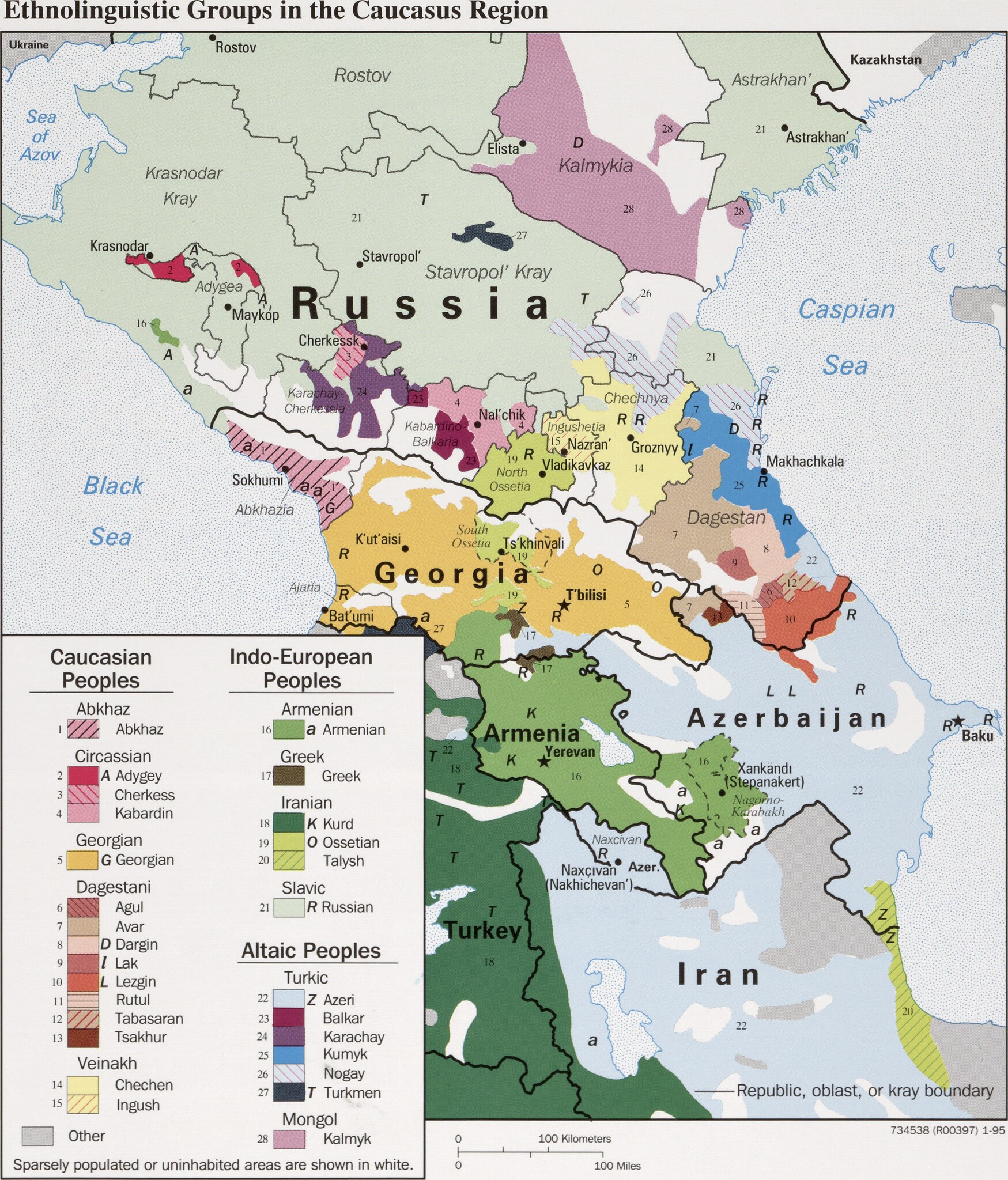
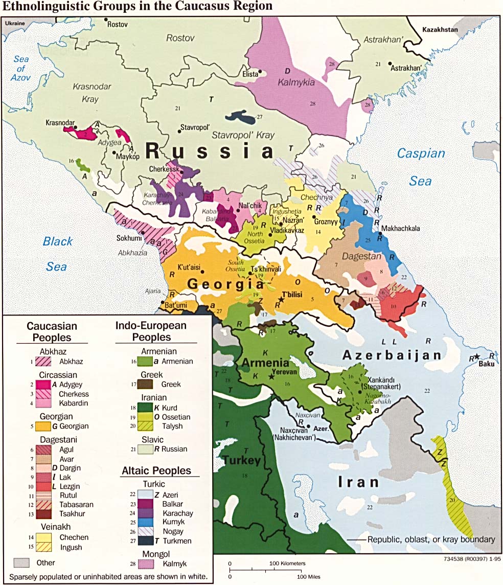
| Deskribapena | CIA map on the ethnolinguistic groups in the Caucasus region. National borders are thick black, regional borders within one country in thin black, and disputed borders as dotted lines. |
| Data | |
| Jatorria |
https://www.loc.gov/item/95680196/ (permalink: https://lccn.loc.gov/95680196)
|
| Egilea | U.S. Central Intelligence Agency |
| Lizentzia (Fitxategi hau berrerabiltzen) |
Source states: "The following maps were produced by the U.S. Central Intelligence Agency, unless otherwise indicated." [1] |
| Beste bertsioak |
[]
|


Lizentzia
| This image is a work of a Central Intelligence Agency employee, taken or made as part of that person's official duties. As a Work of the United States Government, this image or media is in the public domain in the United States.
|

|
Fitxategiaren historia
Data/orduan klik egin fitxategiak orduan zuen itxura ikusteko.
| Data/Ordua | Iruditxoa | Neurriak | Erabiltzailea | Iruzkina | |
|---|---|---|---|---|---|
| oraingoa | 19:49, 29 martxoa 2022 | | 2.606 × 3.051 (2,46 MB) | Cherkash | TIFF from the same source (https://www.loc.gov/item/95680196/) - first maximally cropped and then converted to JPG |
| 11:12, 22 martxoa 2022 |  | 2.610 × 3.085 (2,41 MB) | Sette-quattro | Higher scan from the same source, from https://www.loc.gov/item/95680196/ | |
| 13:22, 4 uztaila 2017 |  | 984 × 1.144 (269 KB) | Mikhail Ryazanov | Reverted to version as of 13:54, 29 November 2005 (UTC) | |
| 07:22, 4 uztaila 2017 |  | 2.000 × 1.126 (1.024 KB) | Abdularehman | mast qalandar welfare association | |
| 07:21, 4 uztaila 2017 |  | 2.000 × 1.126 (1.024 KB) | Abdularehman | mast qalandar welfare association | |
| 15:54, 29 azaroa 2005 |  | 984 × 1.144 (269 KB) | Miaow Miaow | '''CIA map on the Ethno-Linguistic groups in the Caucasus region.''' National borders are thick black, regional borders within one country in thin black, and disputed borders as dotted lines. From http://en.wikipedia.org/wiki/Image:Caucasus-ethnic.jpg f |
Irudira dakarten loturak
Ez dago fitxategi hau darabilen orririk.
Fitxategiaren erabilera orokorra
Hurrengo beste wikiek fitxategi hau darabilte: