
Fitxategi:Map of Ancient Rome 271 AD.svg

Bereizmen handikoa (SVG fitxategia, nominaldi 2.050 × 1.213 pixel, fitxategiaren tamaina: 207 KB)
Fitxategi hau Wikimedia Commonsekoa da. Hango deskribapen orriko informazioa behean duzu. |
Laburpena
| Deskribapena |
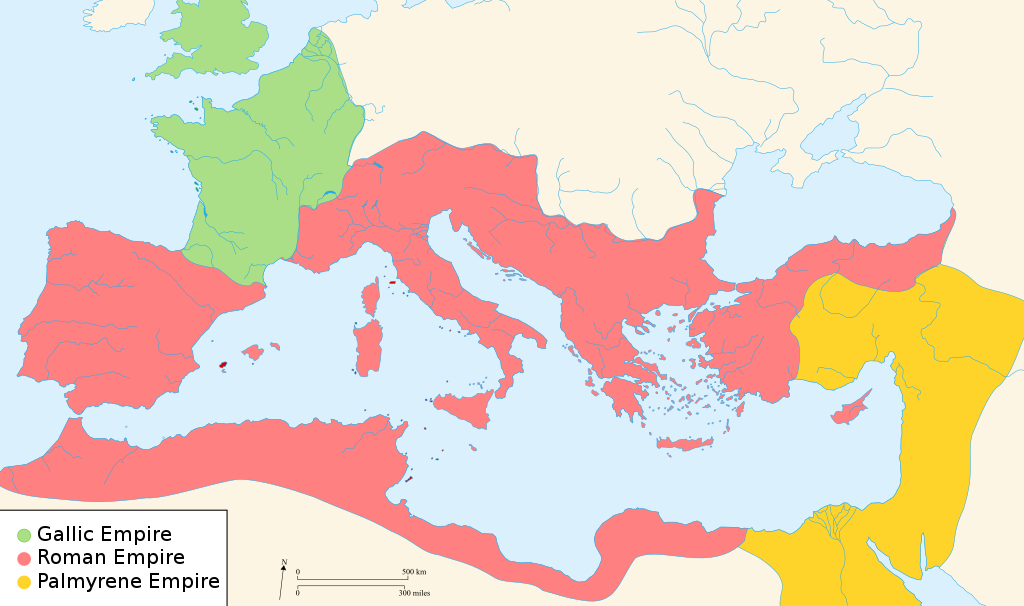
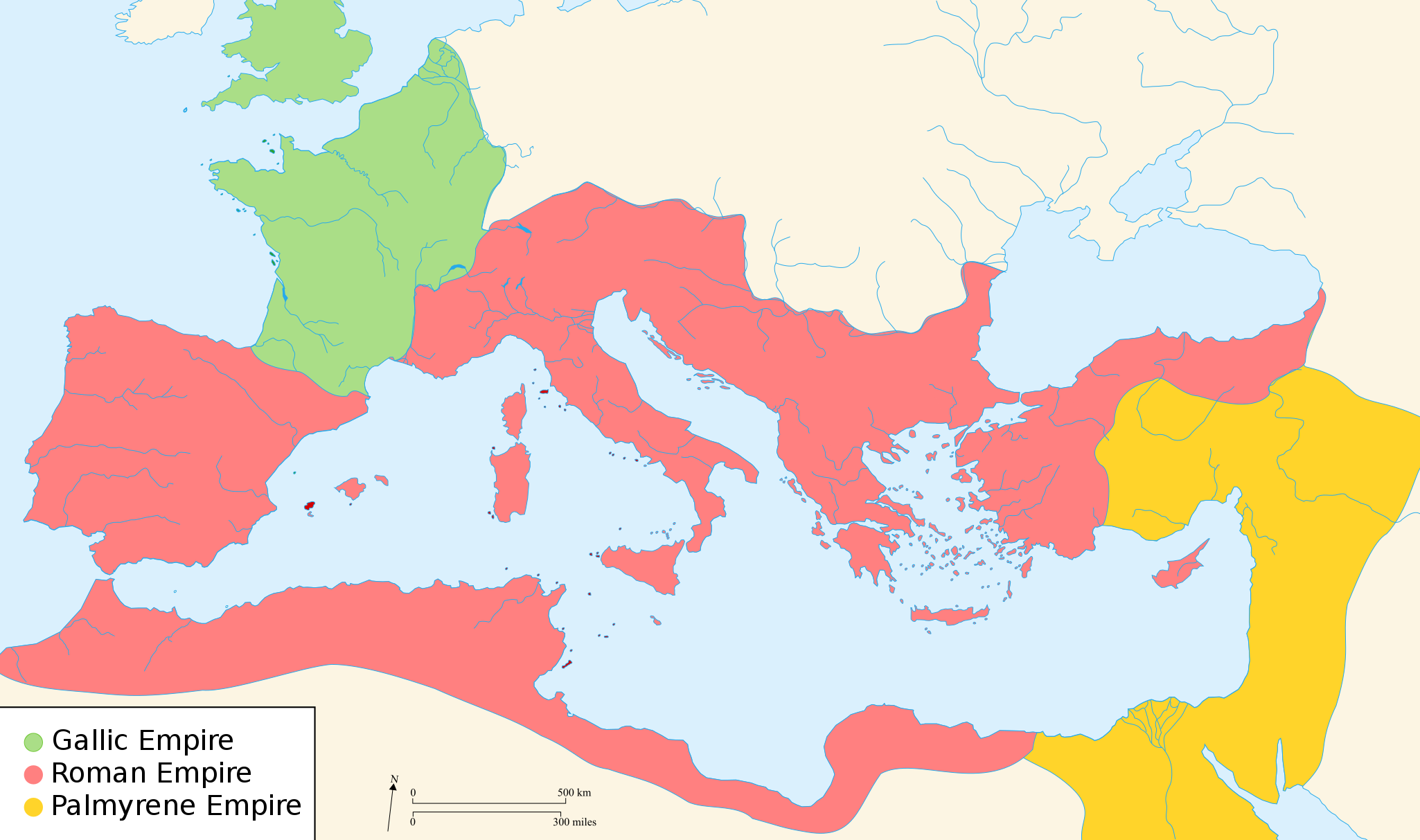
English: Map of the Roman Empire around the year of the consulship of Aurelianus and Bassus (271 AD), with the break away Gallic Empire in the West and the Palmyrene Empire in the East. |
||
| Data | (UTC) | ||
| Jatorria | |||
| Egilea |
|
||
| Lizentzia (Fitxategi hau berrerabiltzen) |
Nik, lan honen egileak, argitaratzen dut ondorengo lizentzia hauen pean:
This file is licensed under the Creative Commons Attribution-Share Alike 2.5 Generic, 2.0 Generic and 1.0 Generic license.
Nahiago duzun lizentzia erabil dezakezu. |
||
| Beste bertsioak |
[]
|


.svg)


|
SVG fitxategi honek Inkscape edo Adobe Illustrator bezalako SVG editore bat erabiliz erraz itzul daitekeen barneratutako testua du. Argibide gehiago. Nahi izanez gero, fitxategia jaitsi eta testu editore bat erabiliz ere itzul dezakezu. |
Lizentzia

|
Baimena duzu dokumentu hau kopiatu, banatu edo/eta aldatzeko GNU Free Documentation License baldintzapean, Free Software Foundationek argitaratutako 1.2 edo ondorengo bertsioan; sekzio aldaezinik gabe, azaleko testurik gabe, eta atzeko azaleko testurik gabe. Lizentziaren kopia dago GNU Free Documentation License izenburudun atalean. Subject to disclaimers. |
Jatorrizko igoera erregistroa
- 2007-11-07 02:47 Justinian43 524×377×8 (26490 bytes) The Mediterranean by 271 A.D -The [[Roman Empire]]. -The breakaway [[Gallic Empire]]. -The breakaway [[Palmyrene Empire]].
- derivative work: Pomalee (talk)
other_versions=Derivative works of this file: Map of Ancient Rome 271 AD-sr.svg Permission= GNU Free Documentation License, Version 1.2, Creative Commons Attribution-ShareAlike license versions 3.0, 2.5, 2.0, and 1.0
- Romanworld271AD.jpg: User:Justinian43, uploaded by User:El_bes
| This is a retouched picture, which means that it has been digitally altered from its original version. Modifications: Used "Blank_map_of_South_Europe_and_North_Africa.svg" to refashion "Romanworld271.jpg". The original can be viewed here: Romanworld271AD.jpg:
|

|
Baimena duzu dokumentu hau kopiatu, banatu edo/eta aldatzeko GNU Free Documentation License baldintzapean, Free Software Foundationek argitaratutako 1.2 edo ondorengo bertsioan; sekzio aldaezinik gabe, azaleko testurik gabe, eta atzeko azaleko testurik gabe. Lizentziaren kopia dago GNU Free Documentation License izenburudun atalean. |
| Fitxategi hau Creative Commons Attribution-Share Alike 3.0 Unported lizentziapean dago. | ||
| ||
| This licensing tag was added to this file as part of the GFDL licensing update. |
Jatorrizko igoera erregistroa
This image is a derivative work of the following images:
- File:Blank_map_of_South_Europe_and_North_Africa.svg licensed with Cc-by-sa-2.5,2.0,1.0, GFDL
- 2007-08-09T20:26:49Z Historicair 2050x1213 (1260388 Bytes)
- 2007-08-09T16:12:00Z Historicair 2050x1213 (351130 Bytes) {{Improving}} {{Information |Description={{fr}}Carte vierge de l'Europe du Sud et du Bassin Méditerranée dans l'Antiquité {{en}}Blank map of South Europe and North Africa at Antic period |Source=Own work + [[Image:Blank map of South Europe and North Africa.svg]] by myself
- File:Romanworld271AD.jpg licensed with GFDL-en
- 2007-11-20T15:23:56Z El bes 524x377 (26490 Bytes) {{Information |Description= The Roman Empire around the year 271 AD, with the break awai Gallic Empire in the West |Source= http://en.wikipedia.org/wiki/Image:Romanworld271AD.JPG |Date= November 20th, 2007 |Author= [[http://e
Uploaded with derivativeFX
Fitxategiaren historia
Data/orduan klik egin fitxategiak orduan zuen itxura ikusteko.
| Data/Ordua | Iruditxoa | Neurriak | Erabiltzailea | Iruzkina | |
|---|---|---|---|---|---|
| oraingoa | 23:07, 20 martxoa 2022 | | 2.050 × 1.213 (207 KB) | Leptictidium | File uploaded using svgtranslate tool (https://svgtranslate.toolforge.org/). Added translation for ca. |
| 07:06, 24 abuztua 2018 |  | 2.050 × 1.213 (207 KB) | Ras67 | frame removed | |
| 17:14, 18 abendua 2011 |  | 2.050 × 1.213 (385 KB) | Wanwa | more pleasant for eyesight colors | |
| 23:39, 27 abuztua 2010 |  | 2.050 × 1.213 (384 KB) | Cplakidas | Corrections: the Agri Decumates beyond the Rhine had been abandoned already in 263, the Provence and Spain had been recovered by Rome in 269, and in 271, Zenobia controlled Asia Minor as far as Ancara at least | |
| 07:30, 26 otsaila 2009 |  | 2.050 × 1.213 (396 KB) | Pomalee | Removed text labels from their paths and created a key. | |
| 06:36, 26 otsaila 2009 |  | 2.050 × 1.213 (393 KB) | Pomalee | Changed the "Palmyran" label to "Palmyrene" | |
| 06:15, 26 otsaila 2009 |  | 2.050 × 1.213 (393 KB) | Pomalee | {{Information |Description={{en}}Map of the Roman Empire around the year 271 AD, with the break away Gallic Empire in the West and the Palmyric Empire in the East. |Source=*File:Map_of_the_Ancient_Rome_at_Caesar_time-fr.svg *[[:File:Romanworld271AD. |
Irudira dakarten loturak
Ez dago fitxategi hau darabilen orririk.
Fitxategiaren erabilera orokorra
Hurrengo beste wikiek fitxategi hau darabilte:
- af.wikipedia.org proiektuan duen erabilera
- als.wikipedia.org proiektuan duen erabilera
- ar.wikipedia.org proiektuan duen erabilera
- azb.wikipedia.org proiektuan duen erabilera
- az.wikipedia.org proiektuan duen erabilera
- be-tarask.wikipedia.org proiektuan duen erabilera
- be.wikipedia.org proiektuan duen erabilera
- ca.wikipedia.org proiektuan duen erabilera
- cs.wikipedia.org proiektuan duen erabilera
- cy.wikipedia.org proiektuan duen erabilera
- de.wikipedia.org proiektuan duen erabilera
- el.wikipedia.org proiektuan duen erabilera
- en.wikipedia.org proiektuan duen erabilera
- 271
- Aurelian
- Claudius Gothicus
- Crisis of the Third Century
- Outline of ancient Rome
- Western Roman Empire
- Tetricus I
- Ancient Rome
- Late Latin
- Fall of the Western Roman Empire
- List of revolutions and rebellions
- Ledringhem
- List of Roman external wars and battles
- User:ChazCAESAR/sandbox
- User:Kazkaskazkasako/Books/History
- Classical Anatolia
- User:Iazyges/WRE format
Ikus fitxategi honen erabilpen global gehiago.