
Fitxategi:-IDAHO-L-0011- Teton Dam Flood - Newdale (5811753523).jpg
Bereizmen handikoa ((2.657 × 1.798 pixel, fitxategiaren tamaina: 510 KB, MIME mota: image/jpeg))
Fitxategi hau Wikimedia Commonsekoa da. Hango deskribapen orriko informazioa behean duzu. |
.jpg)
Laburpena
| Deskribapena |
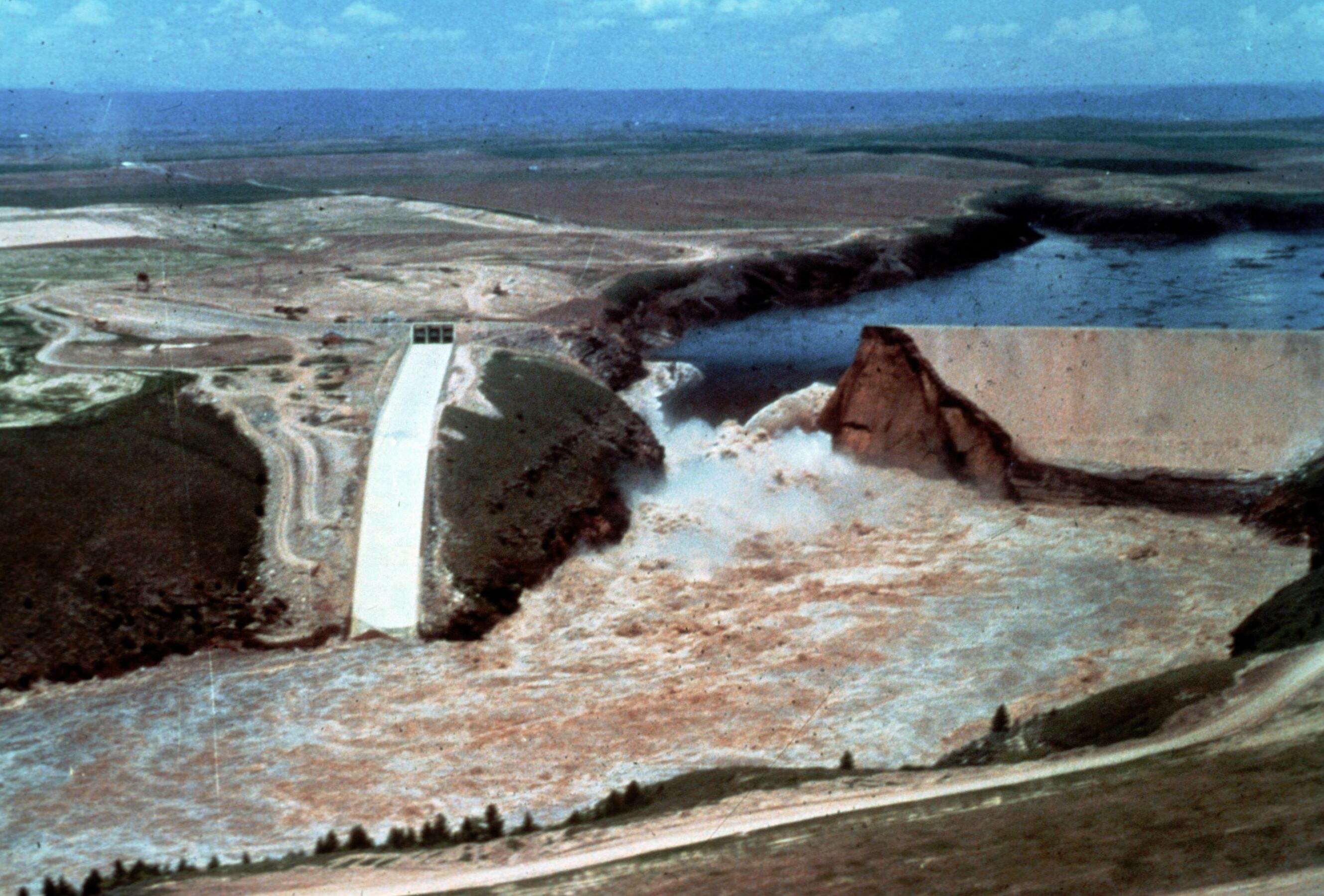
Image Title: Teton Dam Flood - Newdale Date: June 5, 1976 Place: Teton River, Newdale, Idaho Description/Caption: Progressive stages of break in the Dam. Statistics of interest: 80 billion gallons (220,000 acre feet) of water released. Floodwaters' path was seven miles wide in some places (average depth 8-10 feet). 100,000 acres of farmland stripped of topsoil; 13,000 head of livestock killed; 4000 homes, 50 businesses, 3500 farm buildings destroyed. Medium: color transparency Photographer/Maker: Bureau of Reclamation Cite as: ID-L-0011, WaterArchives.org Restrictions: There are no known U.S. copyright restrictions on this image. While the digital image is freely available, it is requested that <a href="http://www.waterarchives.org" target="browser" rel="nofollow">www.waterarchives.org</a> be credited as its source. For higher quality reproductions of the original physical version contact <a href="http://www.waterarchives.org" target="browser" rel="nofollow">www.waterarchives.org</a>, restrictions may apply. |
| Data | |
| Jatorria | [IDAHO-L-0011] Teton Dam Flood - Newdale |
| Egilea | WaterArchives.org from Las Cruces, New Mexico, United States |
| Kameraren kokapena | | Irudi hau eta gehiago beraien kokapenekin hurrengo lekuetan: OpenStreetMap |
|---|
.jpg¶ms=043.910113_N_-111.539983_E_globe:Earth_type:camera_source:Flickr_&language=eu)
Lizentzia
- Askea zara:
- partekatzeko – lana kopiatzeko, banatzeko eta bidaltzeko
- birnahasteko – lana moldatzeko
- Ondorengo baldintzen pean:
- eskuduntza – Egiletza behar bezala aitortu behar duzu, lizentzia ikusteko esteka gehitu, eta ea aldaketak egin diren aipatu. Era egokian egin behar duzu hori guztia, baina inola ere ez egileak zure lana edo zure erabilera babesten duela irudikatuz.
- berdin partekatu – Lan honetan oinarrituta edo aldatuta berria eraikitzen baduzu, emaitza lana hau bezalako lizentzia batekin argitaratu behar duzu.
| This image was originally posted to Flickr by waterarchives at https://flickr.com/photos/23487245@N08/5811753523. It was reviewed on 2020ko ekainaren 15a by FlickreviewR 2 and was confirmed to be licensed under the terms of the cc-by-sa-2.0. |
Fitxategiaren historia
Data/orduan klik egin fitxategiak orduan zuen itxura ikusteko.
| Data/Ordua | Iruditxoa | Neurriak | Erabiltzailea | Iruzkina | |
|---|---|---|---|---|---|
| oraingoa | 17:13, 4 apirila 2023 | | 2.657 × 1.798 (510 KB) | Rémih | Cropped 8 % horizontally, 7 % vertically using CropTool with precise mode. |
| 11:48, 15 ekaina 2020 |  | 2.882 × 1.940 (548 KB) | Kingofthedead | Transferred from Flickr via #flickr2commons |
Irudira dakarten loturak
Hurrengo orrialdeek dute fitxategi honetarako lotura:
Fitxategiaren erabilera orokorra
Hurrengo beste wikiek fitxategi hau darabilte:
- ar.wikipedia.org proiektuan duen erabilera
- arz.wikipedia.org proiektuan duen erabilera
- bg.wikipedia.org proiektuan duen erabilera
- ca.wikipedia.org proiektuan duen erabilera
- ce.wikipedia.org proiektuan duen erabilera
- cy.wikipedia.org proiektuan duen erabilera
- es.wikipedia.org proiektuan duen erabilera
- fr.wikipedia.org proiektuan duen erabilera
- ht.wikipedia.org proiektuan duen erabilera
- it.wikipedia.org proiektuan duen erabilera
- ky.wikipedia.org proiektuan duen erabilera
- lld.wikipedia.org proiektuan duen erabilera
- oc.wikipedia.org proiektuan duen erabilera
- pl.wikipedia.org proiektuan duen erabilera
- sr.wikipedia.org proiektuan duen erabilera
- tt.wikipedia.org proiektuan duen erabilera
- uk.wikipedia.org proiektuan duen erabilera
- uz.wikipedia.org proiektuan duen erabilera
- www.wikidata.org proiektuan duen erabilera
.jpg)