
Fitxategi:AchaemenidMapBehistunInscription.png

Aurreikuspen honen neurria: 800 × 511 pixel. Bestelako bereizmenak: 320 × 205 pixel | 640 × 409 pixel | 1.020 × 652 pixel.
Bereizmen handikoa ((1.020 × 652 pixel, fitxategiaren tamaina: 17 KB, MIME mota: image/png))
Fitxategi hau Wikimedia Commonsekoa da. Hango deskribapen orriko informazioa behean duzu. |
Laburpena
| Deskribapena |
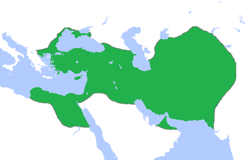
English: This a map of the Achaemenid Empire showing its greatest extent. I have given it more regions as listed on the Behistun Inscription the Persian King Darius wrote telling his conquests. |
| Data | |
| Jatorria | http://en.wikipedia.org/wiki/File:Achemenids500BC.png |
| Egilea | Gabagool |
| Lizentzia (Fitxategi hau berrerabiltzen) |
http://en.wikipedia.org/wiki/File:Achemenids500BC.png |
- Other information
English: This is a map I have edited from that map and it says that I am free to share, to remix, but under the following conditions that i must the work in the manner specified by the author or licensor.
Fitxategi hau Creative Commons Aitortu 1.0 Generikoa lizentziaren mende dago.
- Askea zara:
- partekatzeko – lana kopiatzeko, banatzeko eta bidaltzeko
- birnahasteko – lana moldatzeko
- Ondorengo baldintzen pean:
- eskuduntza – Egiletza behar bezala aitortu behar duzu, lizentzia ikusteko esteka gehitu, eta ea aldaketak egin diren aipatu. Era egokian egin behar duzu hori guztia, baina inola ere ez egileak zure lana edo zure erabilera babesten duela irudikatuz.
Lizentzia
Fitxategi hau Creative Commons Aitortu 3.0 Unported lizentziaren mende dago.
- Askea zara:
- partekatzeko – lana kopiatzeko, banatzeko eta bidaltzeko
- birnahasteko – lana moldatzeko
- Ondorengo baldintzen pean:
- eskuduntza – Egiletza behar bezala aitortu behar duzu, lizentzia ikusteko esteka gehitu, eta ea aldaketak egin diren aipatu. Era egokian egin behar duzu hori guztia, baina inola ere ez egileak zure lana edo zure erabilera babesten duela irudikatuz.
Fitxategiaren historia
Data/orduan klik egin fitxategiak orduan zuen itxura ikusteko.
| Data/Ordua | Iruditxoa | Neurriak | Erabiltzailea | Iruzkina | |
|---|---|---|---|---|---|
| oraingoa | 02:53, 23 urria 2015 | | 1.020 × 652 (17 KB) | LouisAragon | blocked sock. |
| 04:01, 13 urria 2015 |  | 1.020 × 652 (22 KB) | History of Persia | My apologies sir but they did conquer parts of arabia. See the Achaemenid Arabia article. | |
| 03:50, 13 urria 2015 |  | 1.020 × 652 (17 KB) | LouisAragon | Reverted to version as of 22:39, 6 February 2015 (UTC) | |
| 03:24, 13 urria 2015 |  | 1.020 × 652 (22 KB) | LouisAragon | correct. | |
| 03:21, 13 urria 2015 |  | 1.020 × 652 (22 KB) | LouisAragon | They simply did not conquer those territories you just added on all sides. | |
| 01:28, 9 iraila 2015 |  | 1.012 × 648 (19 KB) | History of Persia | More accurate map. info on greek territories: File:Map Greco-Persian Wars-en.svg, size of Mascat (modern Oman/UAE): File:East-Hem 600bc.jpg. clay tablets in old persian have been found in bahrain, so its likely they were part of the achaemenid empire,... | |
| 02:48, 29 uztaila 2015 |  | 1.020 × 652 (20 KB) | History of Persia | made achaemenid arabia better | |
| 02:25, 9 uztaila 2015 |  | 1.020 × 652 (22 KB) | History of Persia | They had also conquered arabia-petrea (though it did not exist with that name) A wikipedia article of the province exists: Achaemenid Arabia | |
| 00:39, 7 otsaila 2015 |  | 1.020 × 652 (17 KB) | HistoryofIran | I aprreciete your effort, but could you please upload the picture instead of replacing it with mine? thanks. | |
| 06:55, 29 urtarrila 2015 |  | 1.020 × 652 (59 KB) | Javierfv1212 | Updated the map by delineating the conquests of the three major Persian conqueror Kings, and also adding the names of the main satrapies of the empire. As a source I used this map of Ian Mladjov's Resources from the University of Michigan's History dep... |
Irudira dakarten loturak
Ez dago fitxategi hau darabilen orririk.
Fitxategiaren erabilera orokorra
Hurrengo beste wikiek fitxategi hau darabilte:
- ar.wikipedia.org proiektuan duen erabilera
- be.wikipedia.org proiektuan duen erabilera
- da.wikipedia.org proiektuan duen erabilera
- en.wikipedia.org proiektuan duen erabilera
- en.wikivoyage.org proiektuan duen erabilera
- eo.wikipedia.org proiektuan duen erabilera
- es.wikipedia.org proiektuan duen erabilera
- fa.wikipedia.org proiektuan duen erabilera
- fr.wikipedia.org proiektuan duen erabilera
- gl.wikipedia.org proiektuan duen erabilera
- hu.wikipedia.org proiektuan duen erabilera
- hy.wikipedia.org proiektuan duen erabilera
- id.wikibooks.org proiektuan duen erabilera
- incubator.wikimedia.org proiektuan duen erabilera
- it.wikipedia.org proiektuan duen erabilera
- it.wikiversity.org proiektuan duen erabilera
- ja.wikipedia.org proiektuan duen erabilera
- la.wikipedia.org proiektuan duen erabilera
- li.wikipedia.org proiektuan duen erabilera
- mg.wikipedia.org proiektuan duen erabilera
- ms.wikipedia.org proiektuan duen erabilera
- no.wikipedia.org proiektuan duen erabilera
- pl.wikipedia.org proiektuan duen erabilera
- pnb.wikipedia.org proiektuan duen erabilera
- ps.wikipedia.org proiektuan duen erabilera
- ru.wikipedia.org proiektuan duen erabilera
- simple.wikipedia.org proiektuan duen erabilera
- sr.wikipedia.org proiektuan duen erabilera
- te.wikipedia.org proiektuan duen erabilera
- th.wikipedia.org proiektuan duen erabilera
- tr.wikipedia.org proiektuan duen erabilera
Ikus fitxategi honen erabilpen global gehiago.