
Fitxategi:Antarctic expedition map (Amundsen - Scott)-en.svg

SVG fitxategi honen PNG aurreikuspenaren tamaina: 610 × 599 pixel. Bestelako bereizmenak: 244 × 240 pixel | 489 × 480 pixel | 782 × 768 pixel | 1.042 × 1.024 pixel | 2.084 × 2.048 pixel | 1.898 × 1.865 pixel.
Bereizmen handikoa (SVG fitxategia, nominaldi 1.898 × 1.865 pixel, fitxategiaren tamaina: 304 KB)
Fitxategi hau Wikimedia Commonsekoa da. Hango deskribapen orriko informazioa behean duzu. |
Laburpena
| Deskribapena |
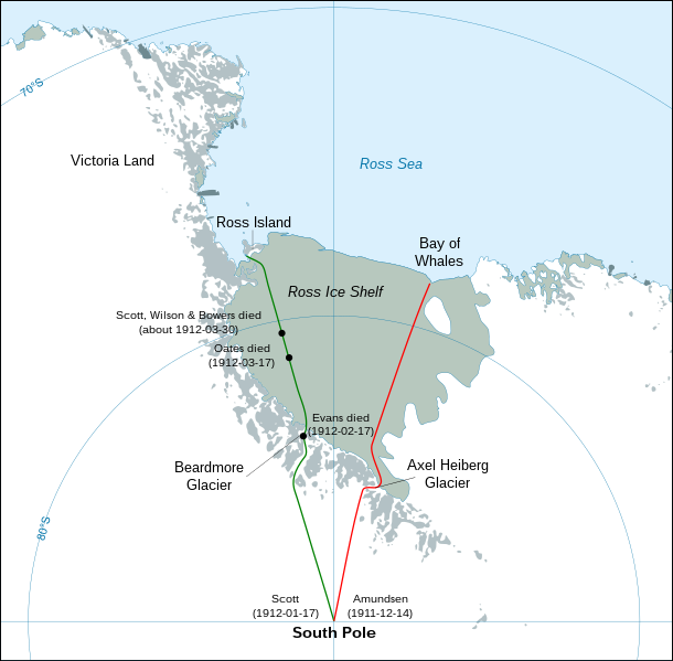
English: Map showing the polar journeys of the Scott's Terra Nova expedition (green) and Amundsen's expedition (red) to reach the South Pole
Français : Carte montrant les parcours de l'expédition Terra Nova de Scott (vert) et celle d'Amundsen (rouge) pour atteindre le Pôle Sud
Español: Mapa mostrando las travesías polares de la expedición Terra Nova de Scott (verde) y la expedición de Amundsen (rojo) para alcanzar el Polo Sur. |
| Data | |
| Jatorria |
Own work using:
|
| Egilea | Shakki |
| Beste bertsioak |
[]
|
-ar.svg)
-bg.svg)
-ca.svg)
-cs.svg)
-cs-colorswap.svg)
-de.svg)
-el.svg)
-en.svg)
-es.svg)
-fr.svg)
-ka.svg)
-no.svg)
-ru.svg)
-he.svg)
-zh-hans.svg)
-zh-hant.svg)
-en.svg)
Lizentzia
| Nik, lan honen egile eskubideen jabeak, lan hau domeinu publikoan jartzen dut. Mundu osoan du eragina honek. Estatu batzuetan beharbada hori ez da legez posible izango. Halakoetan: Edonori ematen diot lan hau edozertarako erabiltzeko eskubidea, inolako baldintzarik gabe, legeak nahitaez ezarritako baldintzak izan ezik. |
| Annotations | This image is annotated: View the annotations at Commons |
Fitxategiaren historia
Data/orduan klik egin fitxategiak orduan zuen itxura ikusteko.
| Data/Ordua | Iruditxoa | Neurriak | Erabiltzailea | Iruzkina | |
|---|---|---|---|---|---|
| oraingoa | 05:30, 29 apirila 2023 | | 1.898 × 1.865 (304 KB) | Pimms1 | Changed dates to YYYY-MM-DD format |
| 23:15, 6 martxoa 2010 |  | 1.898 × 1.865 (306 KB) | S.L. | revert | |
| 23:13, 6 martxoa 2010 |  | 400 × 512 (2,79 MB) | S.L. | better version, mistakes fixed | |
| 20:44, 17 martxoa 2008 |  | 1.898 × 1.865 (306 KB) | Shakki | {{Information |Description={{en|Map showing the polar journeys of the Scott's ''Terra Nova'' expedition (green) and Amundsen's expedition (red) to reach the South Pole}} {{fr|Carte montrant les parcours de l'expédition ''Terra Nova'' de Scott (vert) et c |
Irudira dakarten loturak
Hurrengo orrialdeek dute fitxategi honetarako lotura:
Fitxategiaren erabilera orokorra
Hurrengo beste wikiek fitxategi hau darabilte:
- ar.wikipedia.org proiektuan duen erabilera
- az.wikipedia.org proiektuan duen erabilera
- el.wikipedia.org proiektuan duen erabilera
- en.wikipedia.org proiektuan duen erabilera
- en.wikivoyage.org proiektuan duen erabilera
- es.wikipedia.org proiektuan duen erabilera
- fa.wikipedia.org proiektuan duen erabilera
- fi.wikipedia.org proiektuan duen erabilera
- hu.wikipedia.org proiektuan duen erabilera
- ja.wikipedia.org proiektuan duen erabilera
- la.wikipedia.org proiektuan duen erabilera
- mk.wikipedia.org proiektuan duen erabilera
- nl.wikipedia.org proiektuan duen erabilera
- pl.wikipedia.org proiektuan duen erabilera
- pt.wikipedia.org proiektuan duen erabilera
- ro.wikipedia.org proiektuan duen erabilera
- simple.wikipedia.org proiektuan duen erabilera
- zh.wikipedia.org proiektuan duen erabilera
-en.svg)