
Fitxategi:Avon Aqueduct - geograph.org.uk - 1691980.jpg
Ez dago bereizmen handiagorik.
Avon_Aqueduct_-_geograph.org.uk_-_1691980.jpg ((640 × 442 pixel, fitxategiaren tamaina: 119 KB, MIME mota: image/jpeg))
Fitxategi hau Wikimedia Commonsekoa da. Hango deskribapen orriko informazioa behean duzu. |
Laburpena
| Deskribapena |
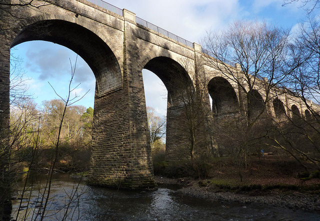
English: Avon Aqueduct This photo shows seven of the twelve arches of the Avon Aqueduct, which carries the Union Canal across the River Avon. At 247 metres long and 25.9 metres high, it is the longest and highest aqueduct in Scotland and the second longest in the UK. It was built between 1819 and 1822 by Hugh Baird (1770-1827), to a design by Thomas Telford (1757-1834) and, unusually, has a towpath on each side. |
| Data | |
| Jatorria | From geograph.org.uk |
| Egilea | Eileen Henderson |
| Aitortu (required by the license) | Eileen Henderson / Avon Aqueduct / |
| Kameraren kokapena | | Irudi hau eta gehiago beraien kokapenekin hurrengo lekuetan: OpenStreetMap |
|---|
_heading:67.00&language=eu)
| Objektuaren kokapena | | Irudi hau eta gehiago beraien kokapenekin hurrengo lekuetan: OpenStreetMap |
|---|
_heading:67.00&language=eu)
Lizentzia

|
This image was taken from the Geograph project collection. See this photograph's page on the Geograph website for the photographer's contact details. The copyright on this image is owned by Eileen Henderson and is licensed for reuse under the Creative Commons Attribution-ShareAlike 2.0 license.
|
This file is licensed under the Creative Commons Attribution-Share Alike 2.0 Generic license.
Aitortu: Eileen Henderson
- Askea zara:
- partekatzeko – lana kopiatzeko, banatzeko eta bidaltzeko
- birnahasteko – lana moldatzeko
- Ondorengo baldintzen pean:
- eskuduntza – Egiletza behar bezala aitortu behar duzu, lizentzia ikusteko esteka gehitu, eta ea aldaketak egin diren aipatu. Era egokian egin behar duzu hori guztia, baina inola ere ez egileak zure lana edo zure erabilera babesten duela irudikatuz.
- berdin partekatu – Lan honetan oinarrituta edo aldatuta berria eraikitzen baduzu, emaitza lana hau bezalako lizentzia batekin argitaratu behar duzu.
Fitxategiaren historia
Data/orduan klik egin fitxategiak orduan zuen itxura ikusteko.
| Data/Ordua | Iruditxoa | Neurriak | Erabiltzailea | Iruzkina | |
|---|---|---|---|---|---|
| oraingoa | 04:49, 5 martxoa 2011 | | 640 × 442 (119 KB) | GeographBot | == {{int:filedesc}} == {{Information |description={{en|1=Avon Aqueduct This photo shows seven of the twelve arches of the Avon Aqueduct, which carries the Union Canal across the River Avon. At 247 metres long and 25.9 metres high, it is the longest and hi |
Irudira dakarten loturak
Hurrengo orrialdeek dute fitxategi honetarako lotura:
Fitxategiaren erabilera orokorra
Hurrengo beste wikiek fitxategi hau darabilte:
- arz.wikipedia.org proiektuan duen erabilera
- ca.wikipedia.org proiektuan duen erabilera
- ceb.wikipedia.org proiektuan duen erabilera
- cs.wikipedia.org proiektuan duen erabilera
- de.wikipedia.org proiektuan duen erabilera
- en.wikipedia.org proiektuan duen erabilera
- nl.wikipedia.org proiektuan duen erabilera
- www.wikidata.org proiektuan duen erabilera