
Fitxategi:Azerbaijan topographic map-fr.svg

SVG fitxategi honen PNG aurreikuspenaren tamaina: 757 × 502 pixel. Bestelako bereizmenak: 320 × 212 pixel | 640 × 424 pixel | 1.024 × 679 pixel | 1.280 × 849 pixel | 2.560 × 1.698 pixel.
Bereizmen handikoa (SVG fitxategia, nominaldi 757 × 502 pixel, fitxategiaren tamaina: 3,07 MB)
Fitxategi hau Wikimedia Commonsekoa da. Hango deskribapen orriko informazioa behean duzu. |
Laburpena
| Deskribapena |
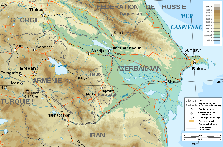
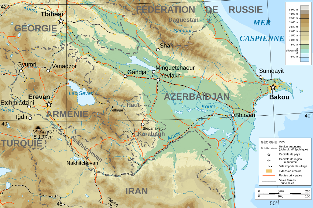
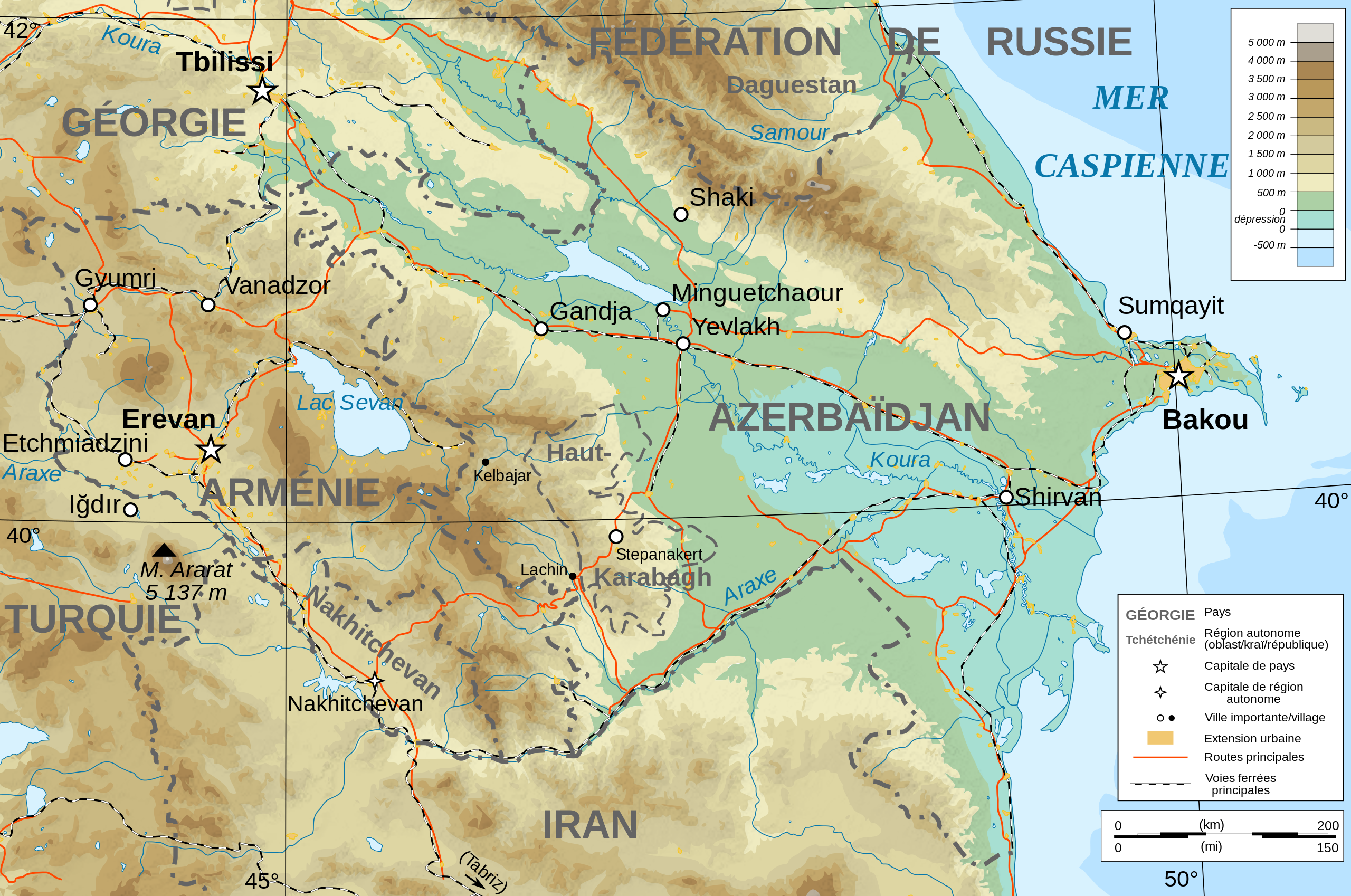
Français : Carte topographique en français de l'Azerbaïdjan et de l'Arménie, avec le Haut-Karabagh en tant que région autonome. |
| Data | |
| Jatorria |
English: Own work ; Topographic data from the NASA Shuttle Radar Topography Mission (SRTM3 v.2) (public domain) edited with 3DEM, reprojected in UTM with GDAL (GDAL), and vectorized with Inkscape ; UTM projection ; WGS84 datum ; shaded relief (composite image of N-W, W and N lightning positions) ; Reference used for the additional data : * Rivers, cities, railroads, routes, bathymetry : Demis add-on for World Wind (see the approval e-mail and the Demis forum) ; * Borders and coast : World data bank II ; Note : The shaded relief is a raster image embedded in the SVG file. Français : Création personnelle ; Données topographiques de la NASA Shuttle Radar Topography Mission (SRTM3 v.2) (domaine public) éditées avec 3DEM, reprojetées en UTM avec GDAL et vectorisées avec Inkscape ; projection UTM ; WGS84 datum ; relief ombré (image composite d'éclairages du N-O, O et N) ; Références utilisées pour les données complémentaires : * Rivières, villes, chemins de fers, routes, bathymétrie : Demis add-on for World Wind (cf. l'e-mail d'approbation de Demis et le Demis forum) ; * Frontières et côtes : World data bank II ; Note : Le relief ombré est une image bitmap embarquée dans le fichier SVG. |
| Egilea | Bourrichon - fr:Bourrichon) |
| Lizentzia (Fitxategi hau berrerabiltzen) |
GFDL / Attribution and Share-Alike required |
| Beste bertsioak |
|
| SVG genesis | Fitxategi hau (bektore-irudia) hau Inkscape-ekin sortu da .
. |


Lizentzia
Nik, lan honen egileak, argitaratzen dut ondorengo lizentzia hauen pean:

|
Baimena duzu dokumentu hau kopiatu, banatu edo/eta aldatzeko GNU Free Documentation License baldintzapean, Free Software Foundationek argitaratutako 1.2 edo ondorengo bertsioan; sekzio aldaezinik gabe, azaleko testurik gabe, eta atzeko azaleko testurik gabe. Lizentziaren kopia dago GNU Free Documentation License izenburudun atalean. |
This file is licensed under the Creative Commons Attribution-Share Alike Attribution-Share Alike 4.0 International, 3.0 Unported, 2.5 Generic, 2.0 Generic and 1.0 Generic license.
- Askea zara:
- partekatzeko – lana kopiatzeko, banatzeko eta bidaltzeko
- birnahasteko – lana moldatzeko
- Ondorengo baldintzen pean:
- eskuduntza – Egiletza behar bezala aitortu behar duzu, lizentzia ikusteko esteka gehitu, eta ea aldaketak egin diren aipatu. Era egokian egin behar duzu hori guztia, baina inola ere ez egileak zure lana edo zure erabilera babesten duela irudikatuz.
- berdin partekatu – Lan honetan oinarrituta edo aldatuta berria eraikitzen baduzu, emaitza lana hau bezalako lizentzia batekin argitaratu behar duzu.
Nahiago duzun lizentzia erabil dezakezu.
Fitxategiaren historia
Data/orduan klik egin fitxategiak orduan zuen itxura ikusteko.
| Data/Ordua | Iruditxoa | Neurriak | Erabiltzailea | Iruzkina | |
|---|---|---|---|---|---|
| oraingoa | 20:12, 10 azaroa 2008 | | 757 × 502 (3,07 MB) | Bourrichon | + corr légende |
| 20:07, 10 azaroa 2008 |  | 757 × 502 (3,07 MB) | Bourrichon | + Iğdır | |
| 19:45, 10 azaroa 2008 |  | 757 × 502 (3,06 MB) | Bourrichon | + cities | |
| 19:25, 9 azaroa 2008 |  | 757 × 502 (3,06 MB) | Bourrichon | ||
| 18:36, 8 azaroa 2008 |  | 757 × 502 (3,06 MB) | Bourrichon | == Summary == {{Information |Description={{de|Topographische Karte von Aserbaidschan und Armenien, französische Version}}{{en|Topographic map in French of Azerbaijan and Armenia}}{ |
Irudira dakarten loturak
Ez dago fitxategi hau darabilen orririk.
Fitxategiaren erabilera orokorra
Hurrengo beste wikiek fitxategi hau darabilte:
- de.wikibooks.org proiektuan duen erabilera
- en.wikipedia.org proiektuan duen erabilera
- eo.wikipedia.org proiektuan duen erabilera
- fi.wikipedia.org proiektuan duen erabilera
- fr.wikipedia.org proiektuan duen erabilera
- pcd.wikipedia.org proiektuan duen erabilera
- ro.wikipedia.org proiektuan duen erabilera
- to.wikipedia.org proiektuan duen erabilera