
Fitxategi:Bono Archaeological Site.jpg

Aurreikuspen honen neurria: 800 × 450 pixel. Bestelako bereizmenak: 320 × 180 pixel | 640 × 360 pixel | 1.024 × 576 pixel | 1.280 × 720 pixel | 2.816 × 1.584 pixel.
Bereizmen handikoa ((2.816 × 1.584 pixel, fitxategiaren tamaina: 1,81 MB, MIME mota: image/jpeg))
Fitxategi hau Wikimedia Commonsekoa da. Hango deskribapen orriko informazioa behean duzu. |
|
This is an image of a place or building that is listed on the National Register of Historic Places in the United States of America. Its reference number is 85001166. |
| Kameraren kokapena | | Irudi hau eta gehiago beraien kokapenekin hurrengo lekuetan: OpenStreetMap |
|---|
| Deskribapena |
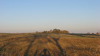
English: Western edge of the Bono Archaeological Site, located on the eastern side of Bono-Tunnelton Road above the East Fork of the White River and one mile north of Bono in Bono Township, Lawrence County, Indiana, United States. Most of the field is a clam shell midden and thus a valuable archaeological site; it is listed on the National Register of Historic Places. |
||
| Data | Taken on 2011ko urriaren 8a | ||
| Jatorria | Norberak egina | ||
| Egilea | Nyttend | ||
| Lizentzia (Fitxategi hau berrerabiltzen) |
|
Fitxategiaren historia
Data/orduan klik egin fitxategiak orduan zuen itxura ikusteko.
| Data/Ordua | Iruditxoa | Neurriak | Erabiltzailea | Iruzkina | |
|---|---|---|---|---|---|
| oraingoa | 14:27, 9 urria 2011 | | 2.816 × 1.584 (1,81 MB) | Nyttend | {{Location|38|44|42|N|86|19|54|W}} {{Information |Description={{en|Western edge of the {{w|Bono Archaeological Site}}, located on the eastern side of Bono-Tunnelton Road above the East Fork of the {{w|White River (Indiana)|White River}} and one mile north |
Irudira dakarten loturak
Hurrengo orrialdeek dute fitxategi honetarako lotura:
Fitxategiaren erabilera orokorra
Hurrengo beste wikiek fitxategi hau darabilte:
- en.wikipedia.org proiektuan duen erabilera
- es.wikipedia.org proiektuan duen erabilera
- ur.wikipedia.org proiektuan duen erabilera
- vi.wikipedia.org proiektuan duen erabilera
- www.wikidata.org proiektuan duen erabilera
- zh.wikipedia.org proiektuan duen erabilera