
Fitxategi:Cannich - geograph.org.uk - 1013238.jpg
Ez dago bereizmen handiagorik.
Cannich_-_geograph.org.uk_-_1013238.jpg ((640 × 480 pixel, fitxategiaren tamaina: 112 KB, MIME mota: image/jpeg))
Fitxategi hau Wikimedia Commonsekoa da. Hango deskribapen orriko informazioa behean duzu. |
Laburpena
| Deskribapena |
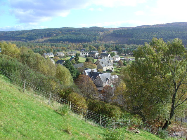
English: Cannich Cannich (Bog Cotton Place), lies in the classic U-shaped glacial valley of Strathglass, which generally runs south west to north east. Three glens lead to/from the village. Glen Cannich to the north west, Glen Affric to the south west and Glenurquhart to the east.
The village was greatly expanded by the arrival of the Hydro Schemes in the area, from the late 1940's. The houses are in MacColl Road, which was named after the Chief Executive and Vice Chairman of the NOSHEB, from 1943 to 1951, Sir Edward MacColl. |
| Data | |
| Jatorria | From geograph.org.uk |
| Egilea | Alasdair MacDonald |
| Aitortu (required by the license) | Alasdair MacDonald / Cannich / |
| Kameraren kokapena | | Irudi hau eta gehiago beraien kokapenekin hurrengo lekuetan: OpenStreetMap |
|---|
_heading:135.00&language=eu)
| Objektuaren kokapena | | Irudi hau eta gehiago beraien kokapenekin hurrengo lekuetan: OpenStreetMap |
|---|
_heading:135.00&language=eu)
Lizentzia

|
This image was taken from the Geograph project collection. See this photograph's page on the Geograph website for the photographer's contact details. The copyright on this image is owned by Alasdair MacDonald and is licensed for reuse under the Creative Commons Attribution-ShareAlike 2.0 license.
|
This file is licensed under the Creative Commons Attribution-Share Alike 2.0 Generic license.
Aitortu: Alasdair MacDonald
- Askea zara:
- partekatzeko – lana kopiatzeko, banatzeko eta bidaltzeko
- birnahasteko – lana moldatzeko
- Ondorengo baldintzen pean:
- eskuduntza – Egiletza behar bezala aitortu behar duzu, lizentzia ikusteko esteka gehitu, eta ea aldaketak egin diren aipatu. Era egokian egin behar duzu hori guztia, baina inola ere ez egileak zure lana edo zure erabilera babesten duela irudikatuz.
- berdin partekatu – Lan honetan oinarrituta edo aldatuta berria eraikitzen baduzu, emaitza lana hau bezalako lizentzia batekin argitaratu behar duzu.
Fitxategiaren historia
Data/orduan klik egin fitxategiak orduan zuen itxura ikusteko.
| Data/Ordua | Iruditxoa | Neurriak | Erabiltzailea | Iruzkina | |
|---|---|---|---|---|---|
| oraingoa | 12:18, 23 otsaila 2011 | | 640 × 480 (112 KB) | GeographBot | == {{int:filedesc}} == {{Information |description={{en|1=Cannich Cannich (Bog Cotton Place), lies in the classic U-shaped glacial valley of Strathglass, which generally runs south west to north east. Three glens lead to/from the village. Glen Cannich to t |
Irudira dakarten loturak
Hurrengo orrialdeek dute fitxategi honetarako lotura:
Fitxategiaren erabilera orokorra
Hurrengo beste wikiek fitxategi hau darabilte: