
Fitxategi:Cape Verde hurricane track.jpg

Aurreikuspen honen neurria: 800 × 296 pixel. Bestelako bereizmenak: 320 × 118 pixel | 640 × 237 pixel | 1.024 × 379 pixel | 2.550 × 944 pixel.
Bereizmen handikoa ((2.550 × 944 pixel, fitxategiaren tamaina: 317 KB, MIME mota: image/jpeg))
Fitxategi hau Wikimedia Commonsekoa da. Hango deskribapen orriko informazioa behean duzu. |
| Deskribapena |
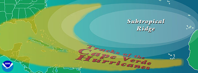
English: Graphic showing the typical track of a en:Cape Verde-type hurricane. The tracks begin south of en:Cape Verde in the eastern en:Atlantic Ocean.
Copyright statusThe NOAA emblem is the property of the U.S. Government and a trademark of the en:United States Department of Commerce. SourceNOAA graphic from http://www.aoml.noaa.gov/hrd/tcfaq/CVtrak.jpg en:nl:Afbeelding:KaapverdischeOrkanen.jpg |
| Data | 2004ko uztailaren 16a (Jatorrizko igoera-data) |
| Jatorria | Transferred from en.wikipedia to Commons by OhanaUnited. |
| Egilea | The original uploader was Cyrius at ingelesa Wikipedia. |
| Beste bertsioak |
|
Lizentzia


This image is in the public domain because it contains materials that originally came from the U.S. National Oceanic and Atmospheric Administration, taken or made as part of an employee's official duties.
|
Jatorrizko igoera erregistroa
The original description page was here. All following user names refer to en.wikipedia.
- 2004-07-16 00:36 Cyrius 2550×944×??? (324839 bytes) PD graphic from NOAA
Fitxategiaren historia
Data/orduan klik egin fitxategiak orduan zuen itxura ikusteko.
| Data/Ordua | Iruditxoa | Neurriak | Erabiltzailea | Iruzkina | |
|---|---|---|---|---|---|
| oraingoa | 19:40, 21 abuztua 2008 | 2.550 × 944 (317 KB) | OhanaUnited | {{Information |Description={{en|Graphic showing the typical track of a en:Cape Verde-type hurricane. The tracks begin south of en:Cape Verde in the eastern en:Atlantic Ocean. ==Copyright status== The NOAA emblem is the property of the [[:e |
Irudira dakarten loturak
Hurrengo orrialdeek dute fitxategi honetarako lotura:
Fitxategiaren erabilera orokorra
Hurrengo beste wikiek fitxategi hau darabilte:
- ca.wikipedia.org proiektuan duen erabilera
- en.wikipedia.org proiektuan duen erabilera
- es.wikipedia.org proiektuan duen erabilera
- fi.wikipedia.org proiektuan duen erabilera
- fr.wikipedia.org proiektuan duen erabilera
- it.wikipedia.org proiektuan duen erabilera
- ko.wikipedia.org proiektuan duen erabilera
- nl.wikipedia.org proiektuan duen erabilera
- pt.wikipedia.org proiektuan duen erabilera
- uk.wikipedia.org proiektuan duen erabilera
- www.wikidata.org proiektuan duen erabilera