
Fitxategi:Central African Republic sub-prefectures.png

Aurreikuspen honen neurria: 800 × 486 pixel. Bestelako bereizmenak: 320 × 194 pixel | 640 × 389 pixel | 1.025 × 623 pixel.
Bereizmen handikoa ((1.025 × 623 pixel, fitxategiaren tamaina: 19 KB, MIME mota: image/png))
Fitxategi hau Wikimedia Commonsekoa da. Hango deskribapen orriko informazioa behean duzu. |

|
This map has been uploaded by Electionworld from en.wikipedia.org to enable the |
Laburpena
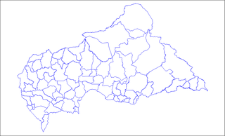
Map of the sub-prefectures of the Central African Republic. Created by Rarelibra 17:58, 31 March 2006 (UTC) for public domain use. Created using MapInfo Professional v7.5 and various mapping resources.
Lizentzia
| Nik, lan honen egile eskubideen jabeak, lan hau domeinu publikoan jartzen dut. Mundu osoan du eragina honek. Estatu batzuetan beharbada hori ez da legez posible izango. Halakoetan: Edonori ematen diot lan hau edozertarako erabiltzeko eskubidea, inolako baldintzarik gabe, legeak nahitaez ezarritako baldintzak izan ezik. |
Fitxategiaren historia
Data/orduan klik egin fitxategiak orduan zuen itxura ikusteko.
| Data/Ordua | Iruditxoa | Neurriak | Erabiltzailea | Iruzkina | |
|---|---|---|---|---|---|
| oraingoa | 11:36, 3 ekaina 2022 | | 1.025 × 623 (19 KB) | Borysk5 | Blue color |
| 19:39, 2 ekaina 2022 |  | 1.025 × 624 (20 KB) | Borysk5 | Updated map | |
| 21:19, 27 azaroa 2006 |  | 1.025 × 624 (18 KB) | Electionworld | {{ew|en|Rarelibra}} == Summary == Map of the sub-prefectures of the Central African Republic. Created by Rarelibra 17:58, 31 March 2006 (UTC) for public domain use. Created using MapInfo Professional v7.5 and various mapping resources. |
Irudira dakarten loturak
Hurrengo orrialdeek dute fitxategi honetarako lotura:
Fitxategiaren erabilera orokorra
Hurrengo beste wikiek fitxategi hau darabilte:
- ca.wikipedia.org proiektuan duen erabilera
- cs.wikipedia.org proiektuan duen erabilera
- en.wikipedia.org proiektuan duen erabilera
- Bangui
- Mobaye
- Bria, Central African Republic
- Obo
- Sibut
- Mbaïki
- Bambari
- Kaga-Bandoro
- Bangassou
- Bouar
- Berbérati
- N'Délé
- Kabo
- Alindao
- Batangafo
- Baoro
- Bimbo, Central African Republic
- Birao
- Boali
- Bossangoa
- Bozoum
- Boda, Lobaye
- Bouca
- Damara, Central African Republic
- Carnot, Central African Republic
- Nola, Central African Republic
- Rafaï
- Mongoumba
- Ouadda
- Ippy
- Kouango
- Kembé
- Paoua
- Gamboula
- Sub-prefectures of the Central African Republic
- User talk:Rarelibra/Maps2
- Bakouma
- Bocaranga
- Ouanda Djallé
- Grimari
- Baboua, Central African Republic
- Bamingui
- Yalinga
- Zemio
- Djemah
- Template:Sub-prefectures of the Central African Republic
- Mingala
- Dekoa
Ikus fitxategi honen erabilpen global gehiago.