
Fitxategi:Claudette 2009 track.png
Aurreikuspen honen neurria: 800 × 495 pixel. Bestelako bereizmenak: 320 × 198 pixel | 640 × 396 pixel | 1.024 × 633 pixel | 1.280 × 791 pixel | 2.700 × 1.669 pixel.
Bereizmen handikoa ((2.700 × 1.669 pixel, fitxategiaren tamaina: 4,09 MB, MIME mota: image/png))
Fitxategi hau Wikimedia Commonsekoa da. Hango deskribapen orriko informazioa behean duzu. |
Laburpena
| Deskribapena |
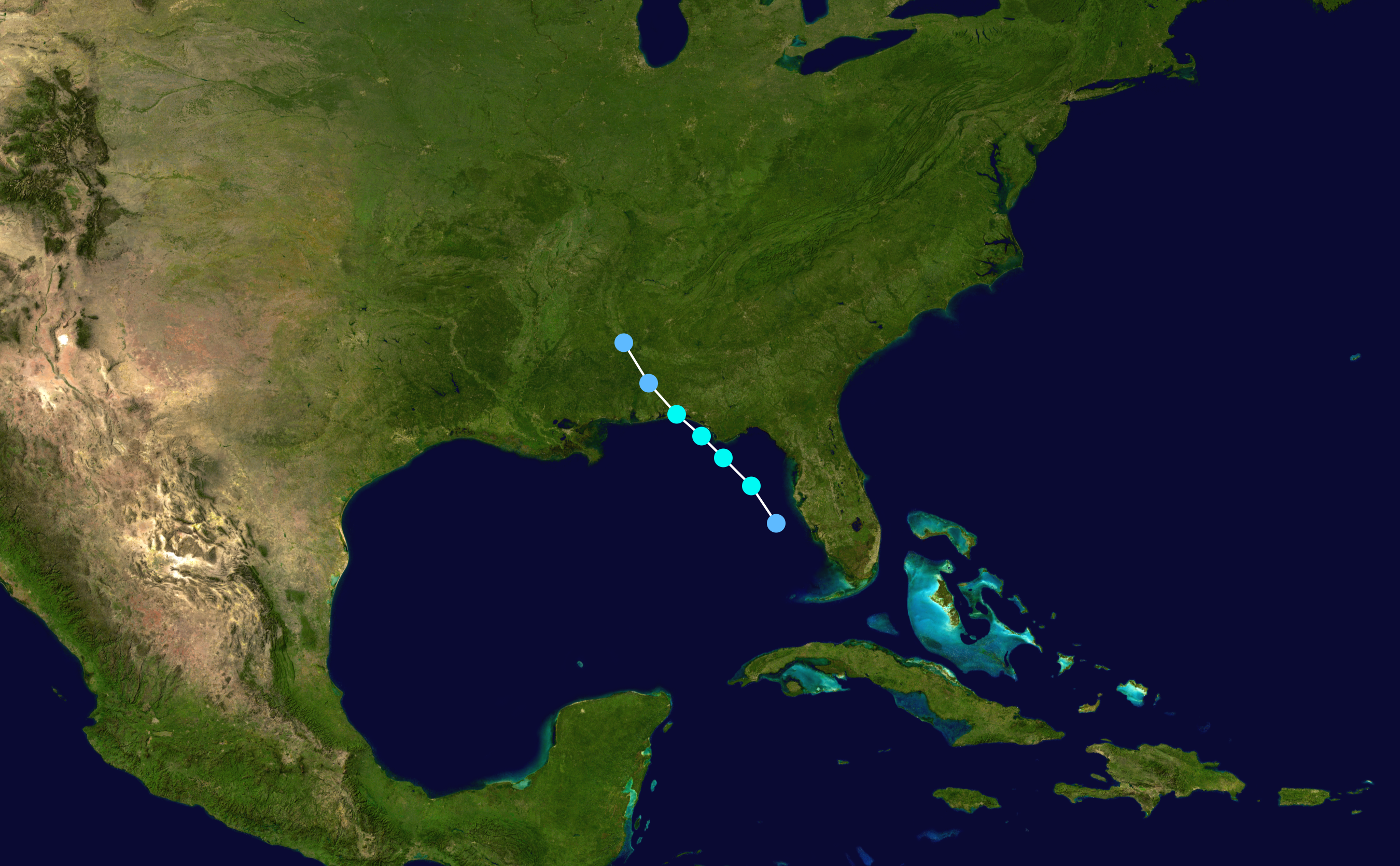
English: Track map of Tropical Storm Claudette of the 2009 Atlantic hurricane season. The points show the location of the storm at 6-hour intervals. The colour represents the storm's maximum sustained wind speeds as classified in the (see below), and the shape of the data points represent the nature of the storm, according to the legend below. Tropical depression (≤38 mph, ≤62 km/h)
Tropical storm (39–73 mph, 63–118 km/h)
Category 1 (74–95 mph, 119–153 km/h)
Category 2 (96–110 mph, 154–177 km/h)
Category 3 (111–129 mph, 178–208 km/h)
Category 4 (130–156 mph, 209–251 km/h)
Category 5 (≥157 mph, ≥252 km/h)
Unknown
Storm type |
||
| Data | 2009-08-16–2009-08-17 | ||
| Jatorria | Created by Cyclonebiskit using Wikipedia:WikiProject Tropical cyclones/Tracks. The background image is from NASA. Tracking data is from the National Hurricane Center[1]. | ||
| Egilea | Cyclonebiskit | ||
| Source code | Track map data table, if present below, is in HURDAT2 or ATCF format. See format details in [2] and [3], respectively.
|
Lizentzia
| This work has been released into the public domain by its author, Cyclonebiskit. This applies worldwide. Estatu batzuetan beharbada hori ez da legez posible izango. Halakoetan: Cyclonebiskit grants anyone the right to use this work for any purpose, without any conditions, unless such conditions are required by law. |
Fitxategiaren historia
Data/orduan klik egin fitxategiak orduan zuen itxura ikusteko.
| Data/Ordua | Iruditxoa | Neurriak | Erabiltzailea | Iruzkina | |
|---|---|---|---|---|---|
| oraingoa | 06:09, 29 uztaila 2019 | | 2.700 × 1.669 (4,09 MB) | Supportstorm | 2700 px |
| 00:57, 13 urtarrila 2010 |  | 1.024 × 633 (690 KB) | Cyclonebiskit | update per TCR | |
| 16:16, 24 abuztua 2009 |  | 1.024 × 633 (713 KB) | Cyclonebiskit | forgot to update with final point | |
| 01:14, 18 abuztua 2009 |  | 1.024 × 633 (680 KB) | Cyclonebiskit | update | |
| 16:56, 17 abuztua 2009 |  | 1.024 × 633 (678 KB) | Cyclonebiskit | update | |
| 07:43, 17 abuztua 2009 |  | 1.024 × 633 (631 KB) | Cyclonebiskit | update | |
| 03:37, 17 abuztua 2009 |  | 1.024 × 633 (617 KB) | Cyclonebiskit | update | |
| 19:58, 16 abuztua 2009 |  | 1.024 × 633 (606 KB) | Cyclonebiskit | tweak | |
| 18:58, 16 abuztua 2009 |  | 1.024 × 633 (606 KB) | Cyclonebiskit | missed a point | |
| 18:35, 16 abuztua 2009 |  | 1.024 × 633 (606 KB) | Cyclonebiskit | {{Information |Description={{en|Track map of Tropical Storm Claudette of the 2009 Atlantic hurricane season. The points show the location of the storm at 6- |
Irudira dakarten loturak
Hurrengo orrialdeek dute fitxategi honetarako lotura:
Fitxategiaren erabilera orokorra
Hurrengo beste wikiek fitxategi hau darabilte:
- cs.wikipedia.org proiektuan duen erabilera
- de.wikipedia.org proiektuan duen erabilera
- en.wikipedia.org proiektuan duen erabilera
- es.wikipedia.org proiektuan duen erabilera
- fr.wikipedia.org proiektuan duen erabilera
- ko.wikipedia.org proiektuan duen erabilera
- pt.wikipedia.org proiektuan duen erabilera
- ru.wikipedia.org proiektuan duen erabilera
- simple.wikipedia.org proiektuan duen erabilera
- sv.wikipedia.org proiektuan duen erabilera
- zh.wikipedia.org proiektuan duen erabilera