
Fitxategi:Cochise County Incorporated and Unincorporated areas Bisbee highlighted.svg

SVG fitxategi honen PNG aurreikuspenaren tamaina: 800 × 565 pixel. Bestelako bereizmenak: 320 × 226 pixel | 640 × 452 pixel | 1.024 × 723 pixel | 1.280 × 904 pixel | 2.560 × 1.807 pixel.
Bereizmen handikoa (SVG fitxategia, nominaldi 850 × 600 pixel, fitxategiaren tamaina: 51 KB)
Fitxategi hau Wikimedia Commonsekoa da. Hango deskribapen orriko informazioa behean duzu. |
Laburpena
| Deskribapena |
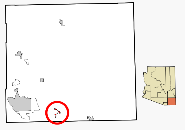
This map shows the incorporated areas and unincorporated areas in Cochise County, Arizona. |
| Data | |
| Jatorria | My own work, based on public domain information |
| Egilea | Ixnayonthetimmay |
| Lizentzia (Fitxategi hau berrerabiltzen) |
Copyleft-type licensing. See below. |
| Beste bertsioak | See Category:Maps of Cochise County for other versions of this image. |
Lizentzia
| Nik, lan honen egile eskubideen jabeak, lan hau domeinu publikoan jartzen dut. Mundu osoan du eragina honek. Estatu batzuetan beharbada hori ez da legez posible izango. Halakoetan: Edonori ematen diot lan hau edozertarako erabiltzeko eskubidea, inolako baldintzarik gabe, legeak nahitaez ezarritako baldintzak izan ezik. |
Fitxategiaren historia
Data/orduan klik egin fitxategiak orduan zuen itxura ikusteko.
| Data/Ordua | Iruditxoa | Neurriak | Erabiltzailea | Iruzkina | |
|---|---|---|---|---|---|
| oraingoa | 20:16, 27 otsaila 2007 | | 850 × 600 (51 KB) | Ixnayonthetimmay | {{Information |Description=This map shows the incorporated areas and unincorporated areas in Cochise County, Arizona. Bisbee is highli |
Irudira dakarten loturak
Hurrengo orrialdeek dute fitxategi honetarako lotura:
Fitxategiaren erabilera orokorra
Hurrengo beste wikiek fitxategi hau darabilte:
- ar.wikipedia.org proiektuan duen erabilera
- arz.wikipedia.org proiektuan duen erabilera
- ca.wikipedia.org proiektuan duen erabilera
- ceb.wikipedia.org proiektuan duen erabilera
- cy.wikipedia.org proiektuan duen erabilera
- de.wikipedia.org proiektuan duen erabilera
- en.wikipedia.org proiektuan duen erabilera
- fa.wikipedia.org proiektuan duen erabilera
- ht.wikipedia.org proiektuan duen erabilera
- hu.wikipedia.org proiektuan duen erabilera
- pt.wikipedia.org proiektuan duen erabilera
- ro.wikipedia.org proiektuan duen erabilera
- sr.wikipedia.org proiektuan duen erabilera
- tr.wikipedia.org proiektuan duen erabilera
- tt.wikipedia.org proiektuan duen erabilera
- www.wikidata.org proiektuan duen erabilera
- zh-min-nan.wikipedia.org proiektuan duen erabilera
- zh.wikipedia.org proiektuan duen erabilera