
Fitxategi:D-angusticeps-range.png

Aurreikuspen honen neurria: 635 × 600 pixel. Bestelako bereizmenak: 254 × 240 pixel | 508 × 480 pixel | 813 × 768 pixel | 1.084 × 1.024 pixel | 1.525 × 1.440 pixel.
Bereizmen handikoa ((1.525 × 1.440 pixel, fitxategiaren tamaina: 432 KB, MIME mota: image/png))
Fitxategi hau Wikimedia Commonsekoa da. Hango deskribapen orriko informazioa behean duzu. |
Laburpena
| Deskribapena |
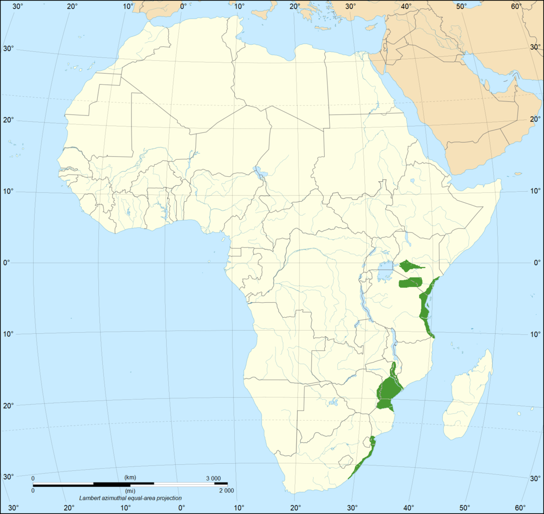
English: The geographical range of the Eastern green mamba in Africa. Data on range is from (2018). "The medical threat of mamba envenoming in sub-Saharan Africa revealed by genus-wide analysis of venom composition, toxicity and antivenomics profiling of available antivenoms". Journal of Proteomics 172: 173–189. DOI:10.1016/j.jprot.2017.08.016. PMID 28843532. Base map is File:Africa map blank.svg |
| Data | |
| Jatorria | Norberak egina |
| Egilea | Casliber |

|
File:Range of the Eastern Green Mamba.svg fitxategi honen bektore bertsioa da. Hau rasterizatutako bertsioaren ordez erabili beharko litzateke hobea izatekotan.
File:D-angusticeps-range.png → File:Range of the Eastern Green Mamba.svg
Grafiko bektorialei buruzko informazioa lortzeko, irakurri SVGra trantsizioa Commonsen. MediaWikiko SVG irudien inguruko laguntza teknikoa ere badago. |
 |
Lizentzia
Nik, lan honen egileak, argitaratzen dut ondorengo lizentzia pean:
| This file is made available under the Creative Commons CC0 1.0 Universal Public Domain Dedication. | |
| The person who associated a work with this deed has dedicated the work to the public domain by waiving all of their rights to the work worldwide under copyright law, including all related and neighboring rights, to the extent allowed by law. You can copy, modify, distribute and perform the work, even for commercial purposes, all without asking permission.
|
Fitxategiaren historia
Data/orduan klik egin fitxategiak orduan zuen itxura ikusteko.
| Data/Ordua | Iruditxoa | Neurriak | Erabiltzailea | Iruzkina | |
|---|---|---|---|---|---|
| oraingoa | 13:27, 13 urria 2019 | | 1.525 × 1.440 (432 KB) | Casliber | Now has accurate range map based on https://doi.org/10.1016/j.jprot.2017.08.016. Base map is now File:Africa map blank.svg |
| 23:34, 27 martxoa 2018 |  | 333 × 365 (18 KB) | Maphobbyist | Actual range | |
| 18:39, 18 abendua 2011 |  | 454 × 398 (12 KB) | Sebastian80~commonswiki |
Irudira dakarten loturak
Hurrengo orrialdeek dute fitxategi honetarako lotura:
Fitxategiaren erabilera orokorra
Hurrengo beste wikiek fitxategi hau darabilte:
- ar.wikipedia.org proiektuan duen erabilera
- arz.wikipedia.org proiektuan duen erabilera
- bg.wikipedia.org proiektuan duen erabilera
- bn.wikipedia.org proiektuan duen erabilera
- ceb.wikipedia.org proiektuan duen erabilera
- cs.wikipedia.org proiektuan duen erabilera
- de.wikipedia.org proiektuan duen erabilera
- es.wikipedia.org proiektuan duen erabilera
- et.wikipedia.org proiektuan duen erabilera
- fa.wikipedia.org proiektuan duen erabilera
- fi.wikipedia.org proiektuan duen erabilera
- frr.wikipedia.org proiektuan duen erabilera
- he.wikipedia.org proiektuan duen erabilera
- hu.wikipedia.org proiektuan duen erabilera
- hy.wikipedia.org proiektuan duen erabilera
- id.wikipedia.org proiektuan duen erabilera
- ne.wikipedia.org proiektuan duen erabilera
- pl.wikipedia.org proiektuan duen erabilera
- pt.wikipedia.org proiektuan duen erabilera
- ro.wikipedia.org proiektuan duen erabilera
- ru.wikipedia.org proiektuan duen erabilera
- sv.wikipedia.org proiektuan duen erabilera
- th.wikipedia.org proiektuan duen erabilera
- uk.wikipedia.org proiektuan duen erabilera
- vi.wikipedia.org proiektuan duen erabilera
- www.wikidata.org proiektuan duen erabilera