
Fitxategi:Eagle Township Works I Mound.jpg

Aurreikuspen honen neurria: 800 × 450 pixel. Bestelako bereizmenak: 320 × 180 pixel | 640 × 360 pixel | 1.024 × 576 pixel | 1.280 × 720 pixel | 2.816 × 1.584 pixel.
Bereizmen handikoa ((2.816 × 1.584 pixel, fitxategiaren tamaina: 1,83 MB, MIME mota: image/jpeg))
Fitxategi hau Wikimedia Commonsekoa da. Hango deskribapen orriko informazioa behean duzu. |
|
This is an image of a place or building that is listed on the National Register of Historic Places in the United States of America. Its reference number is 71000630. |
| Kameraren kokapena | | Irudi hau eta gehiago beraien kokapenekin hurrengo lekuetan: OpenStreetMap |
|---|
| Deskribapena |
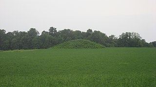
English: View from the east of the Eagle Township Works I Mound, located west of Mound Road about 0.5 miles north of its junction with Fincastle Road, east of Fincastle in Eagle Township, Brown County, Ohio, United States. Built by people of the Adena culture, it is an important archaeological site and is listed on the National Register of Historic Places. |
||
| Data | Taken on 2012ko abuztuaren 13a | ||
| Jatorria | Norberak egina | ||
| Egilea | Nyttend | ||
| Lizentzia (Fitxategi hau berrerabiltzen) |
|
Fitxategiaren historia
Data/orduan klik egin fitxategiak orduan zuen itxura ikusteko.
| Data/Ordua | Iruditxoa | Neurriak | Erabiltzailea | Iruzkina | |
|---|---|---|---|---|---|
| oraingoa | 00:18, 10 urria 2012 | | 2.816 × 1.584 (1,83 MB) | Nyttend | {{NRHP|71000630}} {{Location|38|59|15|N|83|41|47|W}} {{Information |Description={{en|View from the east of the {{w|Eagle Township Works I Mound}}, located west of Mound Road about 0.5 miles north of its junction with Fincastle Road, east of {{w|Fincast... |
Irudira dakarten loturak
Hurrengo orrialdeek dute fitxategi honetarako lotura:
Fitxategiaren erabilera orokorra
Hurrengo beste wikiek fitxategi hau darabilte:
- en.wikipedia.org proiektuan duen erabilera
- es.wikipedia.org proiektuan duen erabilera
- fa.wikipedia.org proiektuan duen erabilera
- pt.wikipedia.org proiektuan duen erabilera
- ur.wikipedia.org proiektuan duen erabilera
- vi.wikipedia.org proiektuan duen erabilera
- www.wikidata.org proiektuan duen erabilera
- zh.wikipedia.org proiektuan duen erabilera