
Fitxategi:Faroe islands map with island names.png

Aurreikuspen honen neurria: 450 × 600 pixel. Bestelako bereizmenak: 180 × 240 pixel | 600 × 800 pixel.
Bereizmen handikoa ((600 × 800 pixel, fitxategiaren tamaina: 29 KB, MIME mota: image/png))
Fitxategi hau Wikimedia Commonsekoa da. Hango deskribapen orriko informazioa behean duzu. |
Laburpena
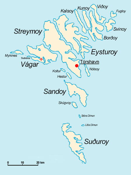
Español: Mapa de las Islas Feroe. Posición del aeropuerto marcado con el avión rojo.
- The Faroe Islands
- Graphics Arne List
- Description: This basic map shows the names of the 18 islands plus the islet Tindhólmur west of Vágar, which is not counted as one of the islands. Furthermore, on this map you see the Airport Vágar and the capital Tórshavn, the two international destinations, if you come via plane or ferry. Last but not least bears the sea no caption, for this map should be translated in different languages by yourself. The sea in the West is the North Atlantic Ocean, and in the East Norwegian Sea (which is a part of the Atlantic).

|
Baimena duzu dokumentu hau kopiatu, banatu edo/eta aldatzeko GNU Free Documentation License baldintzapean, Free Software Foundationek argitaratutako 1.2 edo ondorengo bertsioan; sekzio aldaezinik gabe, azaleko testurik gabe, eta atzeko azaleko testurik gabe. Lizentziaren kopia dago GNU Free Documentation License izenburudun atalean. |
| Fitxategi hau Creative Commons Attribution-Share Alike 3.0 Unported lizentziapean dago. | ||
| ||
| This licensing tag was added to this file as part of the GFDL licensing update. |
derivative works
Derivative works of this file: Faroe islands map with island names-2.JPG
Fitxategiaren historia
Data/orduan klik egin fitxategiak orduan zuen itxura ikusteko.
| Data/Ordua | Iruditxoa | Neurriak | Erabiltzailea | Iruzkina | |
|---|---|---|---|---|---|
| oraingoa | 11:32, 18 azaroa 2004 | | 600 × 800 (29 KB) | Arne List | GFDL |
Irudira dakarten loturak
Hurrengo orrialdeek dute fitxategi honetarako lotura:
Fitxategiaren erabilera orokorra
Hurrengo beste wikiek fitxategi hau darabilte:
- azb.wikipedia.org proiektuan duen erabilera
- be.wikipedia.org proiektuan duen erabilera
- ca.wikipedia.org proiektuan duen erabilera
- cs.wikipedia.org proiektuan duen erabilera
- da.wikipedia.org proiektuan duen erabilera
- de.wikipedia.org proiektuan duen erabilera
- ee.wikipedia.org proiektuan duen erabilera
- eo.wikipedia.org proiektuan duen erabilera
- ext.wikipedia.org proiektuan duen erabilera
- fo.wikipedia.org proiektuan duen erabilera
- fr.wikipedia.org proiektuan duen erabilera
- fr.wiktionary.org proiektuan duen erabilera
- ga.wikipedia.org proiektuan duen erabilera
- gl.wikipedia.org proiektuan duen erabilera
- hu.wikipedia.org proiektuan duen erabilera
- id.wikipedia.org proiektuan duen erabilera
- is.wikipedia.org proiektuan duen erabilera
- mr.wikipedia.org proiektuan duen erabilera
- nl.wikipedia.org proiektuan duen erabilera
- nn.wikipedia.org proiektuan duen erabilera
- no.wikipedia.org proiektuan duen erabilera
- os.wikipedia.org proiektuan duen erabilera
- pl.wikipedia.org proiektuan duen erabilera
- pt.wikipedia.org proiektuan duen erabilera
- ru.wikipedia.org proiektuan duen erabilera
- sh.wikipedia.org proiektuan duen erabilera
- sr.wikipedia.org proiektuan duen erabilera
- sv.wikipedia.org proiektuan duen erabilera
- vi.wikipedia.org proiektuan duen erabilera
Ikus fitxategi honen erabilpen global gehiago.