
Fitxategi:Geographic Tyne and Wear Metro map.svg

SVG fitxategi honen PNG aurreikuspenaren tamaina: 800 × 583 pixel. Bestelako bereizmenak: 320 × 233 pixel | 640 × 466 pixel | 1.024 × 746 pixel | 1.280 × 932 pixel | 2.560 × 1.865 pixel | 1.149 × 837 pixel.
Bereizmen handikoa (SVG fitxategia, nominaldi 1.149 × 837 pixel, fitxategiaren tamaina: 21 KB)
Fitxategi hau Wikimedia Commonsekoa da. Hango deskribapen orriko informazioa behean duzu. |
| Deskribapena |
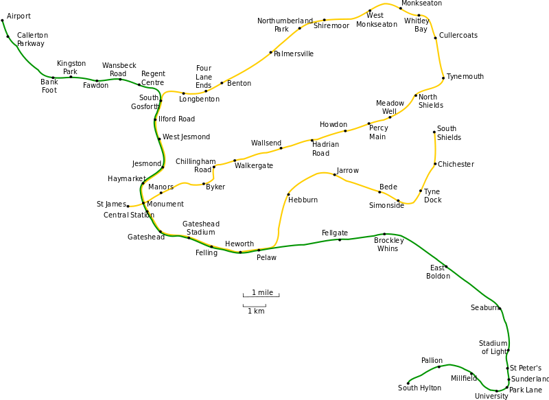
Geographically accurate map of the Tyne and Wear Metro system. t |
| Data | (UTC) |
| Jatorria | |
| Egilea |
|
| This is a retouched picture, which means that it has been digitally altered from its original version. Modifications: Converted to SVG; used larger text font.. The original can be viewed here: Geographic Tyne and Wear Metro map.gif:
|
Nik, lan honen egileak, argitaratzen dut ondorengo lizentzia pean:

|
Baimena duzu dokumentu hau kopiatu, banatu edo/eta aldatzeko GNU Free Documentation License baldintzapean, Free Software Foundationek argitaratutako 1.2 edo ondorengo bertsioan; sekzio aldaezinik gabe, azaleko testurik gabe, eta atzeko azaleko testurik gabe. Lizentziaren kopia dago GNU Free Documentation License izenburudun atalean. |
| Fitxategi hau Creative Commons Attribution-Share Alike 3.0 Unported lizentziapean dago. | ||
| ||
| This licensing tag was added to this file as part of the GFDL licensing update. |
Jatorrizko igoera erregistroa
This image is a derivative work of the following images:
- File:Geographic_Tyne_and_Wear_Metro_map.gif licensed with GFDL
- 2007-07-16T02:55:27Z Responsible? 1189x844 (30138 Bytes) {{Information |Description=Geographically accurate map of the Tyne and Wear Metro system. |Source=Originally from [http://en.wikipedia.org en.wikipedia]; description page is/was [http://en.wikipedia.org/w/index.php?title=Imag
Uploaded with derivativeFX
Fitxategiaren historia
Data/orduan klik egin fitxategiak orduan zuen itxura ikusteko.
| Data/Ordua | Iruditxoa | Neurriak | Erabiltzailea | Iruzkina | |
|---|---|---|---|---|---|
| oraingoa | 12:37, 9 urria 2010 | | 1.149 × 837 (21 KB) | Johnwalton | +Simonside, correct dot placement |
| 00:24, 18 abendua 2009 |  | 1.149 × 837 (54 KB) | Johnwalton | Reverted to version as of 16:27, 1 April 2009... dots are rendering misplaced | |
| 23:59, 17 abendua 2009 |  | 1.149 × 837 (44 KB) | Johnwalton | Added Simonside station. Minor update to some text spacing, and correct spelling of Whitley Bay. | |
| 18:27, 1 apirila 2009 |  | 1.149 × 837 (54 KB) | Aveekbh | {{Information |Description=Geographically accurate map of the Tyne and Wear Metro system. Inkscape-specific SVG, separated into layers for easy editing. |Source=*File:Geographic_Tyne_and_Wear_Metro_map.gif |Date=2009-04-01 17:26 (UTC) |Author=*[[:Fi | |
| 16:01, 1 apirila 2009 |  | 1.149 × 837 (49 KB) | Aveekbh | {{Information |Description=Geographically accurate map of the Tyne and Wear Metro system. t |Source=*File:Geographic_Tyne_and_Wear_Metro_map.gif |Date=2009-04-01 14:59 (UTC) |Author=*File:Geographic_Tyne_and_Wear_Metro_map.gif: Original upload |
Irudira dakarten loturak
Hurrengo orrialdeek dute fitxategi honetarako lotura:
Fitxategiaren erabilera orokorra
Hurrengo beste wikiek fitxategi hau darabilte:
- af.wikipedia.org proiektuan duen erabilera
- ca.wikipedia.org proiektuan duen erabilera
- de.wikipedia.org proiektuan duen erabilera
- de.wikivoyage.org proiektuan duen erabilera
- en.wikipedia.org proiektuan duen erabilera
- es.wikipedia.org proiektuan duen erabilera
- fa.wikipedia.org proiektuan duen erabilera
- fi.wikipedia.org proiektuan duen erabilera
- hu.wikipedia.org proiektuan duen erabilera
- hy.wikipedia.org proiektuan duen erabilera
- it.wikipedia.org proiektuan duen erabilera
- ja.wikipedia.org proiektuan duen erabilera
- ms.wikipedia.org proiektuan duen erabilera
- pl.wikipedia.org proiektuan duen erabilera
- tr.wikipedia.org proiektuan duen erabilera
- www.wikidata.org proiektuan duen erabilera