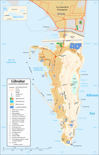
Fitxategi:Gibraltar map-en.svg
Appearance

SVG fitxategi honen PNG aurreikuspenaren tamaina: 385 × 598 pixel. Bestelako bereizmenak: 154 × 240 pixel | 309 × 480 pixel | 494 × 768 pixel | 659 × 1.024 pixel | 1.317 × 2.048 pixel | 2.020 × 3.140 pixel.
Bereizmen handikoa (SVG fitxategia, nominaldi 2.020 × 3.140 pixel, fitxategiaren tamaina: 289 KB)
Fitxategiaren historia
Data/orduan klik egin fitxategiak orduan zuen itxura ikusteko.
| Data/Ordua | Iruditxoa | Neurriak | Erabiltzailea | Iruzkina | |
|---|---|---|---|---|---|
| oraingoa | 22:10, 21 otsaila 2020 |  | 2.020 × 3.140 (289 KB) | JoKalliauer | malformed svg (compare firefox/chrome rendering with librsvg-rendering) actually firefox/chrome were correct, also it looks wrong |
| 08:01, 29 ekaina 2017 |  | 2.020 × 3.140 (538 KB) | Wereldburger758 | Removal error in file. Valid SVG now. | |
| 23:52, 27 abuztua 2008 |  | 2.020 × 3.140 (569 KB) | RedCoat | Remove "claimed by Spain", completely gratuitous for a map | |
| 13:28, 11 abendua 2007 |  | 2.020 × 3.140 (570 KB) | Sting | Notification of the Spanish claims | |
| 16:40, 27 azaroa 2007 |  | 2.020 × 3.140 (569 KB) | Sting | Additional names ; up-to-date corrections | |
| 23:35, 26 azaroa 2007 |  | 2.020 × 3.140 (561 KB) | RedCoat | House of Assembly → Gibraltar Parliament | |
| 21:51, 26 azaroa 2007 |  | 2.020 × 3.140 (561 KB) | Sting | + info | |
| 16:12, 26 azaroa 2007 |  | 2.020 × 3.140 (561 KB) | Sting | + info | |
| 15:21, 26 azaroa 2007 |  | 2.020 × 3.140 (561 KB) | Sting | {{Information |Description=Map in English of Gibraltar |Source=Own work ;<br/>Map created using screenshots of Google Earth satellite imagery from a point of view located at 1.18 km of altitude (available image |
Irudira dakarten loturak
Ez dago fitxategi hau darabilen orririk.
Fitxategiaren erabilera orokorra
Hurrengo beste wikiek fitxategi hau darabilte:
- ar.wikipedia.org proiektuan duen erabilera
- azb.wikipedia.org proiektuan duen erabilera
- ca.wikipedia.org proiektuan duen erabilera
- cs.wikivoyage.org proiektuan duen erabilera
- de.wikipedia.org proiektuan duen erabilera
- en.wikipedia.org proiektuan duen erabilera
- fi.wikipedia.org proiektuan duen erabilera
- fr.wikipedia.org proiektuan duen erabilera
- fy.wikipedia.org proiektuan duen erabilera
- hi.wikipedia.org proiektuan duen erabilera
- id.wikipedia.org proiektuan duen erabilera
- incubator.wikimedia.org proiektuan duen erabilera
- ja.wikipedia.org proiektuan duen erabilera
- la.wikipedia.org proiektuan duen erabilera
- mzn.wikipedia.org proiektuan duen erabilera
- nl.wikipedia.org proiektuan duen erabilera
- no.wikipedia.org proiektuan duen erabilera
- pa.wikipedia.org proiektuan duen erabilera
- pl.wikipedia.org proiektuan duen erabilera
- pt.wikipedia.org proiektuan duen erabilera
- ru.wikipedia.org proiektuan duen erabilera
- sc.wikipedia.org proiektuan duen erabilera
- smn.wikipedia.org proiektuan duen erabilera
- uk.wikipedia.org proiektuan duen erabilera
- www.wikidata.org proiektuan duen erabilera


