
Fitxategi:Great Basin definition map.gif

Aurreikuspen honen neurria: 437 × 599 pixel. Bestelako bereizmenak: 175 × 240 pixel | 572 × 784 pixel.
Bereizmen handikoa ((572 × 784 pixel, fitxategiaren tamaina: 50 KB, MIME mota: image/gif))
Fitxategi hau Wikimedia Commonsekoa da. Hango deskribapen orriko informazioa behean duzu. |
Laburpena
| Deskribapena |
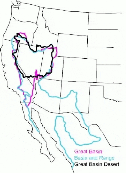
English: The Great Basin can be defined hydrographically (in purple), topographically (in blue), or biologically (in black). |
| Data | (UTC) |
| Jatorria |
Fitxategi hau hemendik eratorria izan da: GB-Definition-Map.jpg:  |
| Egilea |
|
Lizentzia
Original:
| This image or media file contains material based on a work of a National Park Service employee, created as part of that person's official duties. As a work of the U.S. federal government, such work is in the public domain in the United States. See the NPS website and NPS copyright policy for more information. |
Cleanup:
| This file is made available under the Creative Commons CC0 1.0 Universal Public Domain Dedication. | |
| The person who associated a work with this deed has dedicated the work to the public domain by waiving all of their rights to the work worldwide under copyright law, including all related and neighboring rights, to the extent allowed by law. You can copy, modify, distribute and perform the work, even for commercial purposes, all without asking permission.
|
Jatorrizko igoera erregistroa
This image is a derivative work of the following images:
- File:GB-Definition-Map.jpg licensed with PD-USGov-NPS
- 2008-01-02T14:23:51Z Psemper 286x392 (17013 Bytes) {{Information |Description= |Source=http://en.wikipedia.org/wiki/Image:GB-Definition-Map.jpg |Date= |Author= |Permission= |other_versions= }}
Uploaded with derivativeFX
Fitxategiaren historia
Data/orduan klik egin fitxategiak orduan zuen itxura ikusteko.
| Data/Ordua | Iruditxoa | Neurriak | Erabiltzailea | Iruzkina | |
|---|---|---|---|---|---|
| oraingoa | 07:38, 23 martxoa 2024 | | 572 × 784 (50 KB) | Hike395 | optimize gif |
| 05:39, 23 martxoa 2024 |  | 572 × 784 (115 KB) | Hike395 | == {{int:filedesc}} == {{Information |Description={{en|The {{w|Great Basin}} can be defined hydrographically (in purple), topographically (in blue), or biologically (in black).}} |Source={{Derived from|GB-Definition-Map.jpg|display=50}} |Date=2024-03-23 03:38 (UTC) |Author=* File:GB-Definition-Map.jpg: U.S. National Park Service * cleanup: [[User:{{subst:REVISIONUSER}}|{{subst:REVISIONUSER}}]] |Permission= |other_versions= }} == {{int:license-header}} == Origi... |
Irudira dakarten loturak
Hurrengo orrialdeek dute fitxategi honetarako lotura:
Fitxategiaren erabilera orokorra
Hurrengo beste wikiek fitxategi hau darabilte:
- ar.wikipedia.org proiektuan duen erabilera
- arz.wikipedia.org proiektuan duen erabilera
- ast.wikipedia.org proiektuan duen erabilera
- az.wikipedia.org proiektuan duen erabilera
- bg.wikipedia.org proiektuan duen erabilera
- ca.wikipedia.org proiektuan duen erabilera
- de.wikipedia.org proiektuan duen erabilera
- en.wikipedia.org proiektuan duen erabilera
- es.wikipedia.org proiektuan duen erabilera
- gd.wikipedia.org proiektuan duen erabilera
- he.wikipedia.org proiektuan duen erabilera
- hu.wikipedia.org proiektuan duen erabilera
- hy.wikipedia.org proiektuan duen erabilera
- ja.wikipedia.org proiektuan duen erabilera
- ka.wikipedia.org proiektuan duen erabilera
- nl.wikipedia.org proiektuan duen erabilera
- pt.wikipedia.org proiektuan duen erabilera
- ro.wikipedia.org proiektuan duen erabilera
- ru.wikipedia.org proiektuan duen erabilera
- simple.wikipedia.org proiektuan duen erabilera
- sv.wikipedia.org proiektuan duen erabilera
- tr.wikipedia.org proiektuan duen erabilera
- uk.wikipedia.org proiektuan duen erabilera
- vi.wikipedia.org proiektuan duen erabilera
- war.wikipedia.org proiektuan duen erabilera
- www.wikidata.org proiektuan duen erabilera