
Fitxategi:Gulf of Izmit, Turkey.JPG

Aurreikuspen honen neurria: 800 × 532 pixel. Bestelako bereizmenak: 320 × 213 pixel | 640 × 425 pixel | 1.024 × 681 pixel | 1.280 × 851 pixel | 2.560 × 1.701 pixel | 4.288 × 2.850 pixel.
Bereizmen handikoa ((4.288 × 2.850 pixel, fitxategiaren tamaina: 2,6 MB, MIME mota: image/jpeg))
Fitxategi hau Wikimedia Commonsekoa da. Hango deskribapen orriko informazioa behean duzu. |
Laburpena
| Deskribapena |
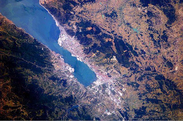
English: This astronaut photograph highlights the metropolitan area of Izmit along the northern and eastern shores of the Sea of Marmara, at the end of the Gulf of Izmit. Commercial and industrial centres—including petroleum refineries and automobile factories—are recognizable by large structures with white rooftops. The smaller city of Gölcük on the southern shoreline of the Gulf is the location of a Turkish naval facility and another automobile factory. Both urban areas are built primarily on flat lowlands adjacent to the Gulf, with green vegetation marking highland areas to the north of Izmit and south of Gölcük. |
| Data | |
| Jatorria | NASA Earth Observatory |
| Egilea | ISS Expedition 24 crew |
| Kameraren kokapena | | Irudi hau eta gehiago beraien kokapenekin hurrengo lekuetan: OpenStreetMap |
|---|
This image or video was catalogued by Johnson Space Center of the United States National Aeronautics and Space Administration (NASA) under Photo ID: ISS024-E-10162. This tag does not indicate the copyright status of the attached work. A normal copyright tag is still required. See Commons:Licensing. Other languages:
|
Image acquired with a Nikon D2Xs digital camera using a 180 mm lens, and is provided by the ISS Crew Earth Observations experiment and Image Science & Analysis Laboratory, Johnson Space Center.
Lizentzia
| This file is in the public domain in the United States because it was solely created by NASA. NASA copyright policy states that "NASA material is not protected by copyright unless noted". (See Template:PD-USGov, NASA copyright policy page or JPL Image Use Policy.) | ||
 |
Warnings:
|
Fitxategiaren historia
Data/orduan klik egin fitxategiak orduan zuen itxura ikusteko.
| Data/Ordua | Iruditxoa | Neurriak | Erabiltzailea | Iruzkina | |
|---|---|---|---|---|---|
| oraingoa | 11:56, 23 abuztua 2010 | | 4.288 × 2.850 (2,6 MB) | Originalwana | {{Information |Description={{en|1=This astronaut photograph highlights the metropolitan area of Izmit along the northern and eastern shores of the Sea of Marmara, at the end of the Gulf of Izmit. [[:Category:Commerc |
Irudira dakarten loturak
Hurrengo orrialdeek dute fitxategi honetarako lotura:
Fitxategiaren erabilera orokorra
Hurrengo beste wikiek fitxategi hau darabilte:
- ar.wikipedia.org proiektuan duen erabilera
- az.wikipedia.org proiektuan duen erabilera
- ba.wikipedia.org proiektuan duen erabilera
- bg.wikipedia.org proiektuan duen erabilera
- bn.wikipedia.org proiektuan duen erabilera
- ca.wikipedia.org proiektuan duen erabilera
- ceb.wikipedia.org proiektuan duen erabilera
- cs.wikipedia.org proiektuan duen erabilera
- en.wikipedia.org proiektuan duen erabilera
- es.wikipedia.org proiektuan duen erabilera
- fa.wikipedia.org proiektuan duen erabilera
- fr.wikipedia.org proiektuan duen erabilera
- he.wikipedia.org proiektuan duen erabilera
- hr.wikipedia.org proiektuan duen erabilera
- id.wikipedia.org proiektuan duen erabilera
- ilo.wikipedia.org proiektuan duen erabilera
- it.wikipedia.org proiektuan duen erabilera
- ka.wikipedia.org proiektuan duen erabilera
- mt.wikipedia.org proiektuan duen erabilera
- nl.wikipedia.org proiektuan duen erabilera
- nn.wikipedia.org proiektuan duen erabilera
- ru.wikipedia.org proiektuan duen erabilera
- tr.wikipedia.org proiektuan duen erabilera
- tr.wikivoyage.org proiektuan duen erabilera
- www.wikidata.org proiektuan duen erabilera
- zh.wikipedia.org proiektuan duen erabilera