
Fitxategi:Holy Roman Empire 1648.svg

Bereizmen handikoa (SVG fitxategia, nominaldi 2.283 × 1.810 pixel, fitxategiaren tamaina: 3,07 MB)
Fitxategi hau Wikimedia Commonsekoa da. Hango deskribapen orriko informazioa behean duzu. |
Laburpena
| Deskribapena |
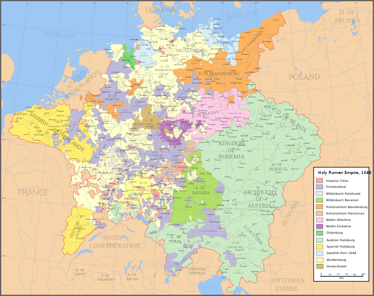
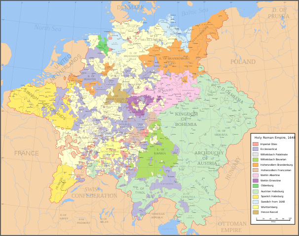
English: Map of the Holy Roman Empire in 1648, after the Peace of Westphalia which ended the Thirty Years' War. Deutsch: Karte des Heiligen Römischen Reiches 1648, nach dem Westfälischer Friede, der den Dreißigjähriger Krieg beendete. Français : Carte du Saint-Empire à 1648, après la paix de Westphalie qui mettent fin à la guerre de Trente Ans. Version française est disponible à File:Holy Roman Empire 1648 fr.svg. Српски / srpski: Мапа Светог римског царства у 1648, након Вестфалског мира којим је завршен Тридесетогодишњи рат.
|
English | Deutsch | Français | Српски |
||
|---|---|---|---|---|---|
| A | Archbishopric | Erzbistum | Archevêché | АДИЈ. | Архидијецеза |
| B | Bishopric | Bistum | Évêché | ДИЈ. | Дијецеза |
| C | County | Grafschaft | Comté | ОКР./ГРОФ. | Округ/грофовија |
| D | Duchy | Herzogtum | Duché | ВОЈВ. | Војводство |
| E | Electorate | Kurfürstentum | Électorat | ЕЛЕКТ. | Електорат |
| L | Landgraviate | Landgrafschaft | Landgraviat | ЛГРОФ. | Ландгрофовија |
| M | Margraviate | Markgrafschaft | Margraviat | МГРОФ. | Маркгрофовија |
| P | Principality | Fürstentum | Principauté | ГРОФ./ОКР. | Грофовија/округ |
Legend / Farblegende / Légende / Легенда
English | Deutsch | Français | Српски |
|
|---|---|---|---|---|
Palatinat des Wittelsbach |
||||
Wittelsbach Bavaria |
Wittelsbacher Bayern |
Bavière des Wittelsbach |
Вителсбах, баварски | |
Hohenzollern Franconia |
Hohenzollerner Franken |
Хоенцолерн, франконски | ||
Wettin Ernestine Saxony |
Wettiner Ernestiner Sachsen |
Saxe de la branche ernestine des Wettin |
Ветин, ернестински | |
Made from the public domain map "Central Europe about 1648" from the Historical Atlas by William R. Shepherd, at the Perry-Castañeda Library Map Collection at the University of Texas. Further information from Overy, Richard, 2006, The Times Complete history of the world Times Books ISBN 0007181299, and from this map
See also other maps at external links:
- Central Europe 1648
- Map on personal site, Europe in 1648
- Treaty of Westphalia
- 1648 map of Prussia
- Britannica, Spanish domains in 1648
(Fitxategi hau berrerabiltzen)

|
Baimena duzu dokumentu hau kopiatu, banatu edo/eta aldatzeko GNU Free Documentation License baldintzapean, Free Software Foundationek argitaratutako 1.2 edo ondorengo bertsioan; sekzio aldaezinik gabe, azaleko testurik gabe, eta atzeko azaleko testurik gabe. Lizentziaren kopia dago GNU Free Documentation License izenburudun atalean. |
| Fitxategi hau Creative Commons Attribution-Share Alike 3.0 Unported lizentziapean dago. | ||
| ||
| This licensing tag was added to this file as part of the GFDL licensing update. |
[]
-
 ingelesa SVG
 -
 gaztelania SVG
 -
 frantsesa SVG
 -
 georgiera SVG
 -
 serbiera SVG
 -
 English: Blank PNG
 -
 ingelesa PNG
 -
 gaztelania PNG
 -
 serbiera PNG
 -
 errusiera PNG


|
SVG fitxategi honek Inkscape edo Adobe Illustrator bezalako SVG editore bat erabiliz erraz itzul daitekeen barneratutako testua du. Argibide gehiago. Nahi izanez gero, fitxategia jaitsi eta testu editore bat erabiliz ere itzul dezakezu. |
Fitxategiaren historia
Data/orduan klik egin fitxategiak orduan zuen itxura ikusteko.
| Data/Ordua | Iruditxoa | Neurriak | Erabiltzailea | Iruzkina | |
|---|---|---|---|---|---|
| oraingoa | 22:43, 24 uztaila 2022 | | 2.283 × 1.810 (3,07 MB) | Maproom | ZWEIBRCKEN -> ZWEIBRÜCKEN, Treves -> Trier, Liege -> Liège |
| 19:55, 18 maiatza 2022 |  | 2.283 × 1.810 (3,07 MB) | Maproom | Consistent, and German, spelling of "Mainz" | |
| 22:11, 25 maiatza 2021 |  | 2.283 × 1.810 (3,07 MB) | ElCet | added the biggest city of Upper Silesia back then | |
| 13:34, 23 martxoa 2018 |  | 2.283 × 1.810 (3,01 MB) | Valentinian | Cleanup some names including missing umlauts. Brunswick-Lüneburg -> Brunswick-Celle (see talk). Border north of Rendsburg seems slightly off to me and the situation in Holstein is rather simplified (jointly administered areas are missing). | |
| 21:09, 8 urria 2010 |  | 2.283 × 1.810 (3,01 MB) | Joostik | Ravenstein as part of Cleves | |
| 21:45, 9 abuztua 2009 |  | 2.283 × 1.810 (3,01 MB) | Ysangkok | simplify code (save as plain svg) | |
| 11:24, 14 uztaila 2009 |  | 2.283 × 1.810 (4,17 MB) | Roke~commonswiki | Zusmarshausen | |
| 17:16, 20 apirila 2007 |  | 2.283 × 1.810 (4,12 MB) | Roke~commonswiki | ||
| 04:04, 20 apirila 2007 |  | 2.283 × 1.810 (4,11 MB) | Roke~commonswiki | rm HRE text, darken labels | |
| 05:04, 18 apirila 2007 |  | 2.283 × 1.810 (4,11 MB) | Roke~commonswiki |
Irudira dakarten loturak
Ez dago fitxategi hau darabilen orririk.
Fitxategiaren erabilera orokorra
Hurrengo beste wikiek fitxategi hau darabilte:
- af.wikipedia.org proiektuan duen erabilera
- azb.wikipedia.org proiektuan duen erabilera
- az.wikipedia.org proiektuan duen erabilera
- br.wikipedia.org proiektuan duen erabilera
- ca.wikipedia.org proiektuan duen erabilera
- ckb.wikipedia.org proiektuan duen erabilera
- cs.wikipedia.org proiektuan duen erabilera
- el.wikipedia.org proiektuan duen erabilera
- en.wikipedia.org proiektuan duen erabilera
- Peace of Westphalia
- Thirty Years' War
- Germans
- Wikipedia:WikiProject Maps
- Imperial Estate
- Talk:Paul Skalich
- Treaty of Fontainebleau (1631)
- Wikipedia:Featured picture candidates/Holy Roman Empire in 1648
- Wikipedia:Featured picture candidates/May-2007
- User talk:Giano II/archive 7
- User:Luosiji/Sandbox
- User:Jammydodger/HRE
- Germany in the early modern period
- User:Zealotzuo/Sandbox
- Wikipedia talk:WikiProject Maps/Archive 5
- Territorial evolution of France
- User:Oaholroyd/sandbox
- User:JMvanDijk/Sandbox 10
- User:DyinRich/Something Else
- Aftermath of the Eighty Years' War
- eo.wikipedia.org proiektuan duen erabilera
- et.wikipedia.org proiektuan duen erabilera
- fa.wikipedia.org proiektuan duen erabilera
- fi.wikipedia.org proiektuan duen erabilera
- fy.wikipedia.org proiektuan duen erabilera
- hu.wikipedia.org proiektuan duen erabilera
- hy.wikipedia.org proiektuan duen erabilera
- id.wikipedia.org proiektuan duen erabilera
- it.wikipedia.org proiektuan duen erabilera
Ikus fitxategi honen erabilpen global gehiago.