
Fitxategi:ISS012-E-23598 NASA-Savai'i east end, Apolima strait, Upolu.jpg

Aurreikuspen honen neurria: 800 × 531 pixel. Bestelako bereizmenak: 320 × 212 pixel | 640 × 424 pixel | 1.024 × 679 pixel | 1.280 × 849 pixel | 3.040 × 2.016 pixel.
Bereizmen handikoa ((3.040 × 2.016 pixel, fitxategiaren tamaina: 1,81 MB, MIME mota: image/jpeg))
Fitxategi hau Wikimedia Commonsekoa da. Hango deskribapen orriko informazioa behean duzu. |
Laburpena
| Deskribapena |
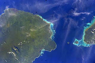
English: East side of Savai'i Island, Apolima, Manono & west end of Upolu |
| Data | |
| Jatorria | Image Science and Analysis Laboratory, NASA-Johnson Space Center. "The Gateway to Astronaut Photography of Earth." <http://eol.jsc.nasa.gov/scripts/sseop/QuickView.pl?directory=ESC&ID=ISS012-E-23598> |
| Egilea | NASA |
| Kameraren kokapena | | Irudi hau eta gehiago beraien kokapenekin hurrengo lekuetan: OpenStreetMap |
|---|
This image or video was catalogued by Johnson Space Center of the United States National Aeronautics and Space Administration (NASA) under Photo ID: ISS012-E-23598. This tag does not indicate the copyright status of the attached work. A normal copyright tag is still required. See Commons:Licensing. Other languages:
|
Lizentzia
This file is in the public domain in the United States because it was created by the Image Science & Analysis Laboratory, of the NASA Johnson Space Center. NASA copyright policy states that "NASA material is not protected by copyright unless noted". (NASA media use guidelines or Conditions of Use of Astronaut Photographs).
Photo source: ISS012-E-23598.
|
Fitxategiaren historia
Data/orduan klik egin fitxategiak orduan zuen itxura ikusteko.
| Data/Ordua | Iruditxoa | Neurriak | Erabiltzailea | Iruzkina | |
|---|---|---|---|---|---|
| oraingoa | 15:41, 18 maiatza 2013 | | 3.040 × 2.016 (1,81 MB) | Ras67 | new rendered from NASA's raw image data |
| 05:14, 7 abuztua 2012 |  | 639 × 423 (88 KB) | Ras67 | rotated and cropped from NASA's original | |
| 15:43, 30 urtarrila 2010 |  | 639 × 435 (62 KB) | Teinesavaii | {{Information |Description={{en|1=East side of Savai'i Island, Apolima, Manono & west end of Upolu}} |Source=Image Science and Analysis Laboratory, NASA-Johnson Space Center. "The Gateway to Astronaut Photography of Earth." <http://eol.jsc.nasa.gov/scri |
Irudira dakarten loturak
Hurrengo orrialdeek dute fitxategi honetarako lotura:
Fitxategiaren erabilera orokorra
Hurrengo beste wikiek fitxategi hau darabilte:
- bn.wikipedia.org proiektuan duen erabilera
- ceb.wikipedia.org proiektuan duen erabilera
- de.wikipedia.org proiektuan duen erabilera
- en.wikipedia.org proiektuan duen erabilera
- es.wikipedia.org proiektuan duen erabilera
- id.wikipedia.org proiektuan duen erabilera
- ka.wikipedia.org proiektuan duen erabilera
- mk.wikipedia.org proiektuan duen erabilera
- mrj.wikipedia.org proiektuan duen erabilera
- no.wikipedia.org proiektuan duen erabilera
- pl.wikipedia.org proiektuan duen erabilera
- ru.wikipedia.org proiektuan duen erabilera
- sk.wikipedia.org proiektuan duen erabilera
- sm.wikipedia.org proiektuan duen erabilera
- uk.wikipedia.org proiektuan duen erabilera
- ur.wikipedia.org proiektuan duen erabilera
- www.wikidata.org proiektuan duen erabilera
- zh.wikipedia.org proiektuan duen erabilera