
Fitxategi:Johnson Road Covered Bridge.jpg

Aurreikuspen honen neurria: 800 × 600 pixel. Bestelako bereizmenak: 320 × 240 pixel | 640 × 480 pixel | 1.024 × 768 pixel.
Bereizmen handikoa ((1.024 × 768 pixel, fitxategiaren tamaina: 320 KB, MIME mota: image/jpeg))
Fitxategi hau Wikimedia Commonsekoa da. Hango deskribapen orriko informazioa behean duzu. |
|
This is an image of a place or building that is listed on the National Register of Historic Places in the United States of America. Its reference number is 84003749. |
| Kameraren kokapena | | Irudi hau eta gehiago beraien kokapenekin hurrengo lekuetan: OpenStreetMap |
|---|
| Deskribapena |
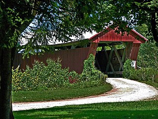
English: One end of the Johnson Road Covered Bridge, which carries Johnson Road over the Brushy Fork of the Little Scioto River near Petersburg in southwestern Scioto Township, Jackson County, Ohio, United States. Built in 1870, it is listed on the National Register of Historic Places. |
| Data | |
| Jatorria | Flickr |
| Egilea | dok1 |
| Lizentzia (Fitxategi hau berrerabiltzen) |
Fitxategi hau Creative Commons Aitorpena 2.0 Generikoa lizentziapean dago.
|
| This image was originally posted to Flickr by dok1 at https://www.flickr.com/photos/51096110@N00/3959315486. It was reviewed on 2010ko apirilaren 3a by FlickreviewR and was confirmed to be licensed under the terms of the cc-by-2.0. |
Fitxategiaren historia
Data/orduan klik egin fitxategiak orduan zuen itxura ikusteko.
| Data/Ordua | Iruditxoa | Neurriak | Erabiltzailea | Iruzkina | |
|---|---|---|---|---|---|
| oraingoa | 05:54, 3 apirila 2010 | | 1.024 × 768 (320 KB) | Nyttend | {{Location|38|57|31|N|82|47|16|W}} {{Information |Description={{en|One end of the {{w|Johnson Road Covered Bridge}}, which carries Johnson Road over the Brushy Fork of the Little Scioto River near {{w|Petersburg, Jackson County, Ohio|Petersburg}} in south |
Irudira dakarten loturak
Hurrengo orrialdeek dute fitxategi honetarako lotura:
Fitxategiaren erabilera orokorra
Hurrengo beste wikiek fitxategi hau darabilte:
- en.wikipedia.org proiektuan duen erabilera
- en.wikivoyage.org proiektuan duen erabilera
- es.wikipedia.org proiektuan duen erabilera
- fa.wikipedia.org proiektuan duen erabilera
- pt.wikipedia.org proiektuan duen erabilera
- vi.wikipedia.org proiektuan duen erabilera
- www.wikidata.org proiektuan duen erabilera
- zh.wikipedia.org proiektuan duen erabilera