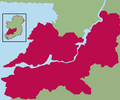
Fitxategi:Kingdom of Thomond.png
Appearance

Aurreikuspen honen neurria: 800 × 462 pixel. Bestelako bereizmenak: 320 × 185 pixel | 640 × 369 pixel | 1.024 × 591 pixel | 1.655 × 955 pixel.
Bereizmen handikoa ((1.655 × 955 pixel, fitxategiaren tamaina: 137 KB, MIME mota: image/png))
Fitxategiaren historia
Data/orduan klik egin fitxategiak orduan zuen itxura ikusteko.
| Data/Ordua | Iruditxoa | Neurriak | Erabiltzailea | Iruzkina | |
|---|---|---|---|---|---|
| oraingoa | 20:24, 7 abendua 2021 |  | 1.655 × 955 (137 KB) | SKIBLY101 | much more realistic map... to the west are uí fidgenti, to the south the deisis and the east are o'carroll ely, why dont you give an actual source before challenging this instead of drawing arbitrary lines based on nothing |
| 22:48, 20 ekaina 2009 |  | 539 × 449 (30 KB) | Thomas Gun | colour | |
| 08:24, 19 apirila 2009 |  | 539 × 449 (32 KB) | Thomas Gun | colour | |
| 10:07, 29 abendua 2008 |  | 539 × 449 (36 KB) | Thomod | {{Information |Description= |Source= |Date= |Author= |Permission= |other_versions= }} | |
| 10:04, 29 abendua 2008 |  | 539 × 449 (36 KB) | Thomod | {{Information |Description= |Source= |Date= |Author= |Permission= |other_versions= }} | |
| 10:01, 29 abendua 2008 |  | 539 × 449 (36 KB) | Thomod | {{Information |Description= |Source= |Date= |Author= |Permission= |other_versions= }} | |
| 09:54, 29 abendua 2008 |  | 539 × 449 (36 KB) | Thomod | {{Information |Description= |Source= |Date= |Author= |Permission= |other_versions= }} | |
| 12:34, 26 abendua 2008 |  | 357 × 430 (37 KB) | Thomod | {{Information |Description= Rough map of the Kingdom of Thomond. Most sources describe it as in the area of the modern day Diocese of Killaloe, this is the boundaries which have been used |Source=myself |Date=26 December 2008 |Author=self-created |Permiss | |
| 12:13, 26 abendua 2008 |  | 357 × 430 (38 KB) | Thomod | {{Information |Description= Rough map of the Kingdom of Thomond. Most sources describe it as in the area of the modern day Diocese of Killaloe, this is the boundaries which have been used |Source=myself |Date=26 December 2008 |Author=self-created |Permiss |
Irudira dakarten loturak
Hurrengo orrialdeek dute fitxategi honetarako lotura:
Fitxategiaren erabilera orokorra
Hurrengo beste wikiek fitxategi hau darabilte:
- ca.wikipedia.org proiektuan duen erabilera
- de.wikipedia.org proiektuan duen erabilera
- en.wikipedia.org proiektuan duen erabilera
- es.wikipedia.org proiektuan duen erabilera
- fr.wikipedia.org proiektuan duen erabilera
- ga.wikipedia.org proiektuan duen erabilera
- id.wikipedia.org proiektuan duen erabilera
- it.wikipedia.org proiektuan duen erabilera
- ko.wikipedia.org proiektuan duen erabilera
- no.wikipedia.org proiektuan duen erabilera
- ru.wikipedia.org proiektuan duen erabilera
- uk.wikipedia.org proiektuan duen erabilera
- www.wikidata.org proiektuan duen erabilera

