
Fitxategi:Leuchtturm in Westerheversand.jpg
Aurreikuspen honen neurria: 800 × 600 pixel. Bestelako bereizmenak: 320 × 240 pixel | 640 × 480 pixel | 1.024 × 768 pixel | 1.280 × 960 pixel | 2.560 × 1.919 pixel | 3.860 × 2.894 pixel.
Bereizmen handikoa ((3.860 × 2.894 pixel, fitxategiaren tamaina: 12,13 MB, MIME mota: image/jpeg))
Fitxategi hau Wikimedia Commonsekoa da. Hango deskribapen orriko informazioa behean duzu. |
Laburpena
| Deskribapena |
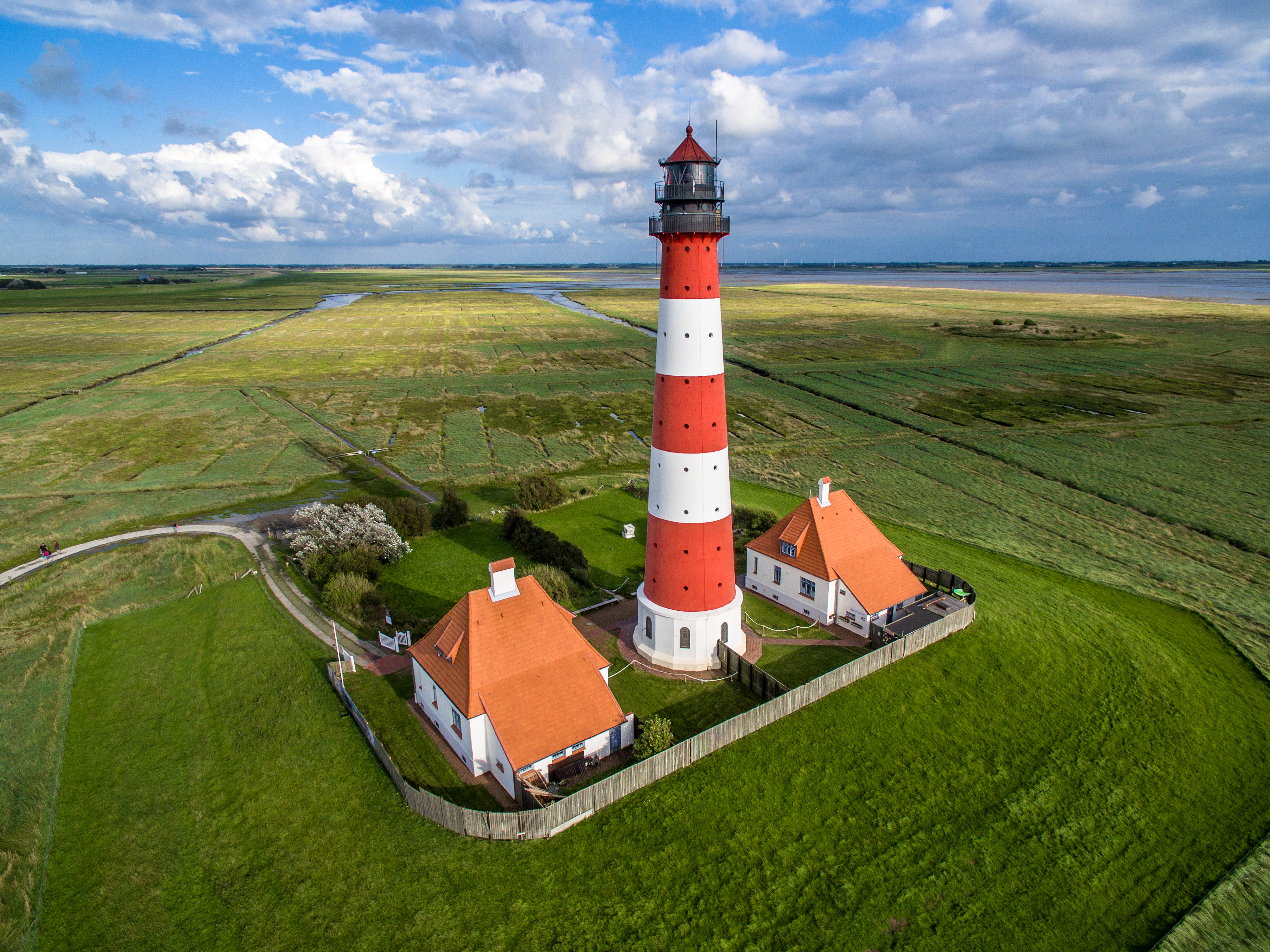
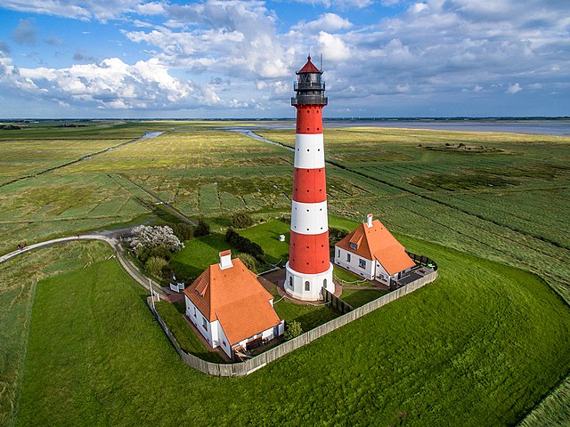
Deutsch: Luftbildaufnahme des Leuchtturms in Westerheversand
English: Aerial photograph of Westerheversand Lighthouse
Esperanto: Aera bildo de la lumturo de Westerheversand
Español: Veduta aérea del faro de Westerheversand
Euskara: Westerheversandeko itsasargiaren aireko bista
Français : Vue aérienne du phare de Westerheversand
Русский: Аэрофотосъемка Вестерхеферского маяка
Українська: Аерофотозйомка Вестергеферського маяка, Шлезвіг-Гольштейн, Німеччина |
| Data | |
| Jatorria | Norberak egina |
| Egilea | Marco Leiter |
| Beste bertsioak |
|

| Objektuaren kokapena | | Irudi hau eta gehiago beraien kokapenekin hurrengo lekuetan: OpenStreetMap |
|---|
| Kameraren kokapena | | Irudi hau eta gehiago beraien kokapenekin hurrengo lekuetan: OpenStreetMap |
|---|
Notes

|
Irudi hau Wiki Loves Monuments 2015 proiektuaren barruan igo da.
|
Assessment

|
This image was awarded with the 1st prize worldwide in Wiki Loves Monuments 2015 Other languages:
|
Irudi hau Kalitate irudien gidalerroen arabera baloratua izan da, eta ondorioz, Kalitatezko irudi izendatua izan da.
|
Lizentzia
- Object
|
The photographical reproduction of this work is covered under the article § 59 of the German copyright law, which states that "It shall be permissible to reproduce, by painting, drawing, photography or cinematography, works which are permanently located on public ways, streets or places and to distribute and publicly communicate such copies. For works of architecture, this provision shall be applicable only to the external appearance."
As with all other “limits of copyright by legally permitted uses”, no changes to the actual work are permitted under § 62 of the German copyright law (UrhG). See Commons:Copyright rules by territory/Germany#Freedom of panorama for more information.
|
- Argazki
Nik, lan honen egileak, argitaratzen dut ondorengo lizentzia pean:
This file is licensed under the Creative Commons Attribution-Share Alike 4.0 International license.
- Askea zara:
- partekatzeko – lana kopiatzeko, banatzeko eta bidaltzeko
- birnahasteko – lana moldatzeko
- Ondorengo baldintzen pean:
- eskuduntza – Egiletza behar bezala aitortu behar duzu, lizentzia ikusteko esteka gehitu, eta ea aldaketak egin diren aipatu. Era egokian egin behar duzu hori guztia, baina inola ere ez egileak zure lana edo zure erabilera babesten duela irudikatuz.
- berdin partekatu – Lan honetan oinarrituta edo aldatuta berria eraikitzen baduzu, emaitza lana hau bezalako lizentzia batekin argitaratu behar duzu.
Fitxategiaren historia
Data/orduan klik egin fitxategiak orduan zuen itxura ikusteko.
| Data/Ordua | Iruditxoa | Neurriak | Erabiltzailea | Iruzkina | |
|---|---|---|---|---|---|
| oraingoa | 22:04, 8 iraila 2016 | | 3.860 × 2.894 (12,13 MB) | Nightflyer | Bearbeitet: Am rechten Rand war eine 1 Pixel breite weisse Linie. |
| 13:02, 24 urria 2015 |  | 3.861 × 2.894 (8,74 MB) | Phantom3Pix | Mit Hilfe von Nightflyer unzählige Staubflecken im Himmel entfernt, Horizont begradigt und leicht nachgedunkelt. | |
| 18:12, 22 urria 2015 |  | 3.992 × 2.992 (9,94 MB) | Phantom3Pix | Reverted to version as of 20:33, 19 October 2015 (UTC) | |
| 16:54, 22 urria 2015 |  | 3.931 × 2.946 (8,78 MB) | Phantom3Pix | Turm im Lot. | |
| 22:33, 19 urria 2015 |  | 3.992 × 2.992 (9,94 MB) | Phantom3Pix | Bildkorrektur | |
| 17:56, 13 iraila 2015 |  | 3.992 × 2.992 (9,94 MB) | Phantom3Pix | User created page with UploadWizard |
Irudira dakarten loturak
Hurrengo orrialdeek dute fitxategi honetarako lotura:
Fitxategiaren erabilera orokorra
Hurrengo beste wikiek fitxategi hau darabilte:
- ar.wikipedia.org proiektuan duen erabilera
- bn.wikipedia.org proiektuan duen erabilera
- ca.wikipedia.org proiektuan duen erabilera
- cs.wikipedia.org proiektuan duen erabilera
- de.wikipedia.org proiektuan duen erabilera
- Portal:Schleswig-Holstein
- Wiki Loves Monuments
- Wikipedia:Wiki Loves Monuments 2015/Deutschland/Preisträger
- Benutzer:Aeroid/Waddensea
- Wikipedia:Kurier/Ausgabe 10 2015
- Wikipedia Diskussion:Kurier/Archiv/2015/12
- Wikipedia:Lokal K/Drohnenfotografie
- Wikipedia:Kurier/Ausgabe 12 2015
- Wikipedia Diskussion:Wiki Loves Monuments 2016/Deutschland
- Wikipedia:Kurier/Ausgabe 1 2016
- Benutzer:Markus Bärlocher/Leuchtfeuer
- Wikipedia:Wiki Loves Monuments 2016/Deutschland/Rückblick
- Wikipedia:Wiki Loves Monuments 2016/Deutschland/Mitmachen/Bilder verwenden
- Wikipedia:Wiki Loves Monuments 2017/Deutschland/Rückblick
- Wikipedia:Wiki Loves Monuments 2017/Deutschland/Mitmachen/Nutzen
- Wikipedia:Wiki Loves Monuments 2018/Deutschland/Rückblick
- Wikipedia:Wiki Loves Monuments 2018/Deutschland
- Benutzer:Martin Rulsch (WMDE)/Test3
- Wikipedia:Wiki Loves Monuments 2018/Deutschland/Nutzen
- Benutzer:Magnus Manske/Kulturdenkmale Schleswig-Holstein U-Z
- Wikipedia:Wiki Loves Monuments 2019/Deutschland/Rückblick
- Wikipedia:Wiki Loves Monuments 2019/Deutschland/Nutzen
- Benutzer:Akuckartz
- Wikipedia:Wiki Loves Monuments 2020/Deutschland/Nutzen
- Wikipedia:Wiki Loves Monuments 2020/Deutschland/Rückblick
- Wikipedia:Wiki Loves Monuments 2021/Deutschland/Nutzen
- Wikipedia:Wiki Loves Monuments 2021/Deutschland/Rückblick
- Wikipedia:Wiki Loves Monuments 2022/Deutschland/Nutzen
- Wikipedia:Wiki Loves Monuments 2022/Deutschland/Rückblick
- Schleswig-Holsteinische Marschen und Nordseeinseln
- Wikipedia:Wiki Loves Monuments 2023/Deutschland/Nutzen
- Wikipedia:Wiki Loves Monuments 2023/Deutschland/Preise
- de.wikivoyage.org proiektuan duen erabilera
- dty.wikipedia.org proiektuan duen erabilera
- el.wikipedia.org proiektuan duen erabilera
- en.wikipedia.org proiektuan duen erabilera
Ikus fitxategi honen erabilpen global gehiago.