
Fitxategi:Manhattan Highlight New York City Map Julius Schorzman.png

Aurreikuspen honen neurria: 616 × 600 pixel. Bestelako bereizmenak: 247 × 240 pixel | 493 × 480 pixel | 789 × 768 pixel | 1.052 × 1.024 pixel | 2.104 × 2.048 pixel | 2.652 × 2.582 pixel.
Bereizmen handikoa ((2.652 × 2.582 pixel, fitxategiaren tamaina: 4,68 MB, MIME mota: image/png))
Fitxategi hau Wikimedia Commonsekoa da. Hango deskribapen orriko informazioa behean duzu. |
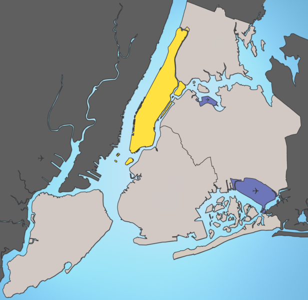
A map of New York City with Manhattan highlighted.
Notes:
- Marble Hill is shown as part Manhattan, part Bronx. See Wikipedia:Marble Hill, Manhattan, New York for more information.
- Governors Island, Ellis Island, Liberty Island, Randall's Island, and Roosevelt Island are highlighted since they are in New York County and are governmentally a part of Manhattan.
Source: I created this image using various maps and images. Attribution: Julius Schorzman
This file is licensed under the Creative Commons Attribution-Share Alike 2.5 Generic license.
- Askea zara:
- partekatzeko – lana kopiatzeko, banatzeko eta bidaltzeko
- birnahasteko – lana moldatzeko
- Ondorengo baldintzen pean:
- eskuduntza – Egiletza behar bezala aitortu behar duzu, lizentzia ikusteko esteka gehitu, eta ea aldaketak egin diren aipatu. Era egokian egin behar duzu hori guztia, baina inola ere ez egileak zure lana edo zure erabilera babesten duela irudikatuz.
- berdin partekatu – Lan honetan oinarrituta edo aldatuta berria eraikitzen baduzu, emaitza lana hau bezalako lizentzia batekin argitaratu behar duzu.
Fitxategiaren historia
Data/orduan klik egin fitxategiak orduan zuen itxura ikusteko.
| Data/Ordua | Iruditxoa | Neurriak | Erabiltzailea | Iruzkina | |
|---|---|---|---|---|---|
| oraingoa | 03:59, 19 abuztua 2005 | | 2.652 × 2.582 (4,68 MB) | Quasipalm | A map of New York City with Manhattan highlighted. Notes: # '''Marble Hill''' is shown as part Manhattan, part Bronx. See wiki:Marble Hill for more information. # '''Governors Island''', '''Ellis Island''', '''Liberty Island''', '''Randall's Island' |
| 03:54, 19 abuztua 2005 |  | 2.652 × 2.582 (4,68 MB) | Quasipalm | A map of New York City with Manhattan highlighted. Notes: # '''Marble Hill''' is shown as part Manhattan, part Bronx. See wiki:Marble Hill for more information. # '''Governors Island''', '''Ellis Island''', '''Liberty Island''', '''Randall's Island' |
Irudira dakarten loturak
Hurrengo orrialdeek dute fitxategi honetarako lotura:
Fitxategiaren erabilera orokorra
Hurrengo beste wikiek fitxategi hau darabilte:
- bg.wikipedia.org proiektuan duen erabilera
- bn.wikipedia.org proiektuan duen erabilera
- bs.wikipedia.org proiektuan duen erabilera
- ca.wikipedia.org proiektuan duen erabilera
- de.wikipedia.org proiektuan duen erabilera
- en.wikipedia.org proiektuan duen erabilera
- es.wikipedia.org proiektuan duen erabilera
- fa.wikipedia.org proiektuan duen erabilera
- fo.wikipedia.org proiektuan duen erabilera
- frr.wikipedia.org proiektuan duen erabilera
- fr.wikipedia.org proiektuan duen erabilera
- ga.wikipedia.org proiektuan duen erabilera
- he.wikipedia.org proiektuan duen erabilera
- hi.wikipedia.org proiektuan duen erabilera
- hr.wikipedia.org proiektuan duen erabilera
- hu.wikipedia.org proiektuan duen erabilera
- id.wikipedia.org proiektuan duen erabilera
- is.wikipedia.org proiektuan duen erabilera
- it.wikipedia.org proiektuan duen erabilera
- ja.wikipedia.org proiektuan duen erabilera
- ka.wikipedia.org proiektuan duen erabilera
- kn.wikipedia.org proiektuan duen erabilera
- lt.wikipedia.org proiektuan duen erabilera
- mk.wikipedia.org proiektuan duen erabilera
- mr.wikipedia.org proiektuan duen erabilera
- ms.wikipedia.org proiektuan duen erabilera
- pcd.wikipedia.org proiektuan duen erabilera
- pnb.wikipedia.org proiektuan duen erabilera
- pt.wikipedia.org proiektuan duen erabilera
- ro.wikipedia.org proiektuan duen erabilera
- ru.wikipedia.org proiektuan duen erabilera
Ikus fitxategi honen erabilpen global gehiago.