
Fitxategi:Mapa sujetos federales de Rusia.svg

SVG fitxategi honen PNG aurreikuspenaren tamaina: 666 × 599 pixel. Bestelako bereizmenak: 267 × 240 pixel | 533 × 480 pixel | 853 × 768 pixel | 1.138 × 1.024 pixel | 2.275 × 2.048 pixel | 1.131 × 1.018 pixel.
Bereizmen handikoa (SVG fitxategia, nominaldi 1.131 × 1.018 pixel, fitxategiaren tamaina: 243 KB)
Fitxategi hau Wikimedia Commonsekoa da. Hango deskribapen orriko informazioa behean duzu. |
| Deskribapena |
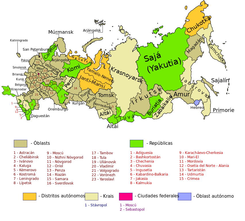
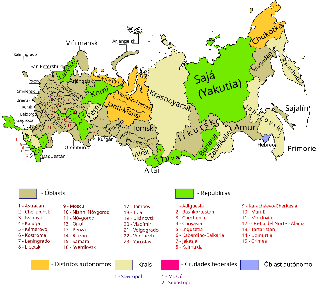
Map of Russia with merged subjects (01.03.2008, last merger Chita Oblast+Agin-Buryat Autonomous Okrug to form Zabaykalsky Krai.) Colour tagged by type. Republics Krais (territories) Oblasts (provinces) federal cities Autonomous oblasts (provinces) Autonomous okrugs (districts) *There is also a layer for the different Federal districts (seen as thicker line on map)
== |
| Data | (UTC) |
| Jatorria | |
| Egilea |
|
Fitxategi hau Creative Commons Attribution-Share Alike 3.0 Unported lizentziapean dago.
- Askea zara:
- partekatzeko – lana kopiatzeko, banatzeko eta bidaltzeko
- birnahasteko – lana moldatzeko
- Ondorengo baldintzen pean:
- eskuduntza – Egiletza behar bezala aitortu behar duzu, lizentzia ikusteko esteka gehitu, eta ea aldaketak egin diren aipatu. Era egokian egin behar duzu hori guztia, baina inola ere ez egileak zure lana edo zure erabilera babesten duela irudikatuz.
- berdin partekatu – Lan honetan oinarrituta edo aldatuta berria eraikitzen baduzu, emaitza lana hau bezalako lizentzia batekin argitaratu behar duzu.
Jatorrizko igoera erregistroa
This image is a derivative work of the following images:
- File:Map_of_Russian_subjects_by_type,_2008-03-01.svg licensed with Cc-by-sa-2.5
- 2008-04-20T16:46:28Z Lokal Profil 1092x630 (262037 Bytes) Reverted to version as of 22:58, 3 March 2008. Find the new colours to similar
- 2008-04-20T16:13:29Z SeNeKa 1092x630 (260512 Bytes)
- 2008-03-03T22:58:27Z Lokal Profil 1092x630 (262037 Bytes) Update including federal borders
- 2008-01-27T20:52:55Z Lokal Profil 1092x630 (192969 Bytes) Changed colour palett
- 2008-01-27T20:35:39Z Lokal Profil 1092x630 (191362 Bytes) {{Information |Description=Map of Russia with merged subjects (01.03.2008, last merger [[w:en:Chita Oblast|Chita Oblast]]+[[w:en:Agin-Buryat Autonomous Okrug|Agin-Buryat Autonomous Okrug]] to form Zabaykalsky Krai.) Colour ta
- File:Russian-regions.png licensed with Cc-by-sa-3.0-migrated, GFDL
- 2008-03-01T11:47:25Z Legnaw 644x453 (398887 Bytes) == Краткое описание == Based on [[w:Image:Federal subjects of Russia (by type).png]] by [[w:User:Morwen|Morwen]] and [[User:Nightstallion|Nightstallion]]. Editted by [[w:User:Legnaw|Legnaw]]. == Licensing == {{
- 2008-01-01T13:57:47Z Nightstallion 644x453 (60552 Bytes) ust-orda buryatia is gone
- 2007-07-22T10:22:33Z Conscious 644x453 (56203 Bytes) update as of 1.07.2007
- 2007-01-01T18:50:20Z Conscious 644x453 (158776 Bytes) update as of today
- 2006-09-13T19:49:24Z Tavork 644x453 (189520 Bytes) Based on [[w:Image:Federal subjects of Russia (by type).png]] by [[User:Morwen]] and [[User:Nightstallion]]. Editted by [[User:Tavork]].
Uploaded with derivativeFX
Fitxategiaren historia
Data/orduan klik egin fitxategiak orduan zuen itxura ikusteko.
| Data/Ordua | Iruditxoa | Neurriak | Erabiltzailea | Iruzkina | |
|---|---|---|---|---|---|
| oraingoa | 23:17, 17 urtarrila 2024 | | 1.131 × 1.018 (243 KB) | Lusitol | A Crimeia e Sevastopol não são territorio russo. São territorio ucraniano. |
| 01:59, 20 uztaila 2015 |  | 1.131 × 1.018 (252 KB) | Viet-hoian1 | largura de la línea | |
| 10:13, 7 apirila 2014 |  | 1.131 × 1.018 (251 KB) | Wadim | Ajusto el área de Crimea, añado Sebastopol. | |
| 21:52, 27 martxoa 2014 |  | 1.131 × 1.018 (243 KB) | Wadim | El mapa de sujetos federales por definición refleja la jurisdicción interna de Rusia | |
| 00:36, 27 martxoa 2014 |  | 1.037 × 1.018 (343 KB) | Fobos92 | Reverted to version as of 17:09, 24 December 2009 | |
| 02:51, 25 martxoa 2014 |  | 1.131 × 1.018 (243 KB) | Jhon.mauro | Anexión de la República de Crimea y la Ciudad Federada de Sebastopol | |
| 19:09, 24 abendua 2009 |  | 1.037 × 1.018 (343 KB) | Wadim | He agrupado la mitad superior de la imagen, ya que no se visualiza correctamente. | |
| 18:54, 24 abendua 2009 |  | 1.037 × 1.018 (340 KB) | Wadim | {{Information |Description=Map of Russia with merged subjects (01.03.2008, last merger Chita Oblast+Agin-Buryat Autonomous Okrug to form Zabaykalsky Krai.)<br> Colour tagged by type. {{legend|#73 |
Irudira dakarten loturak
Hurrengo orrialdeek dute fitxategi honetarako lotura:
Fitxategiaren erabilera orokorra
Hurrengo beste wikiek fitxategi hau darabilte:
- pt.wikipedia.org proiektuan duen erabilera
- vec.wikipedia.org proiektuan duen erabilera