
Fitxategi:Massif du Mont-Blanc depuis Vétraz.jpg

Aurreikuspen honen neurria: 800 × 372 pixel. Bestelako bereizmenak: 320 × 149 pixel | 640 × 298 pixel | 1.024 × 476 pixel | 1.280 × 596 pixel | 3.888 × 1.809 pixel.
Bereizmen handikoa ((3.888 × 1.809 pixel, fitxategiaren tamaina: 4,47 MB, MIME mota: image/jpeg))
Fitxategi hau Wikimedia Commonsekoa da. Hango deskribapen orriko informazioa behean duzu. |
Laburpena
-
 PNG from RAW file
 -


| Deskribapena |
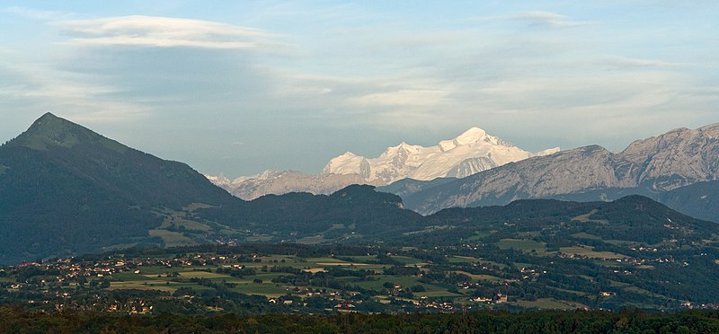
English: Mont Blanc Massif from Vétraz-Monthoux (60 km), Haute-Savoie. From left to right, Aiguille Verte and Grand Dru, Aiguille du Midi, Mont Blanc du Tacul, Mont Maudit, Mont Blanc, Aiguille de Bionnassay. In front, Dôme and Aiguille du Goûter.
Français : Massif du Mont-Blanc depuis Vétraz-Monthoux (60 km), Haute-Savoie. Sont visibles, de gauche à droite : la Verte et le Grand Dru, l'Aiguille du Midi, Mont Blanc du Tacul, Mont Maudit, Mont Blanc, Aiguille de Bionnassay. Devant, le Dôme et l'Aiguille du Goûter. |
| Data | |
| Jatorria | Norberak egina |
| Egilea | Yann (talk) |
| Aitortu (required by the license) | This file is not in the public domain. Therefore you are requested to use the following next to the image if you reuse this file: © Yann Forget / Wikimedia Commons / |
| Kameraren kokapena | | Irudi hau eta gehiago beraien kokapenekin hurrengo lekuetan: OpenStreetMap |
|---|
Lizentzia
Nik, lan honen egileak, argitaratzen dut ondorengo lizentzia hauen pean:

|
Baimena duzu dokumentu hau kopiatu, banatu edo/eta aldatzeko GNU Free Documentation License baldintzapean, Free Software Foundationek argitaratutako 1.2 edo ondorengo bertsioan; sekzio aldaezinik gabe, azaleko testurik gabe, eta atzeko azaleko testurik gabe. Lizentziaren kopia dago GNU Free Documentation License izenburudun atalean. |
This file is licensed under the Creative Commons Attribution-Share Alike 4.0 International, 3.0 Unported, 2.5 Generic, 2.0 Generic and 1.0 Generic license.
- Askea zara:
- partekatzeko – lana kopiatzeko, banatzeko eta bidaltzeko
- birnahasteko – lana moldatzeko
- Ondorengo baldintzen pean:
- eskuduntza – Egiletza behar bezala aitortu behar duzu, lizentzia ikusteko esteka gehitu, eta ea aldaketak egin diren aipatu. Era egokian egin behar duzu hori guztia, baina inola ere ez egileak zure lana edo zure erabilera babesten duela irudikatuz.
- berdin partekatu – Lan honetan oinarrituta edo aldatuta berria eraikitzen baduzu, emaitza lana hau bezalako lizentzia batekin argitaratu behar duzu.
Nahiago duzun lizentzia erabil dezakezu.
Fitxategiaren historia
Data/orduan klik egin fitxategiak orduan zuen itxura ikusteko.
| Data/Ordua | Iruditxoa | Neurriak | Erabiltzailea | Iruzkina | |
|---|---|---|---|---|---|
| oraingoa | 00:46, 4 uztaila 2009 | | 3.888 × 1.809 (4,47 MB) | Iotatau | With permission of Yann I uploaded a new version, this time directly processed from the RAW file. |
| 16:05, 1 uztaila 2009 |  | 3.269 × 1.516 (2,87 MB) | Iotatau | With the permission of the original author Yann I reduced the maximum input level to 215 of 255 (corresponds to brightening) and lifted shadows by 40% in Photoshop CS3, performed a slight noise reduction in Nikon Capture NX2 with 4% strength | |
| 13:02, 1 uztaila 2009 |  | 3.272 × 1.908 (2,73 MB) | Yann | cropped | |
| 12:57, 1 uztaila 2009 |  | 3.888 × 2.592 (4,19 MB) | Yann | {{Information |Description= {{fr|Mont-Blanc depuis Vétraz-Montoux, Haute-Savoie. Sont visibles, de gauche à droite : la Verte et le Grand Dru, l'Aiguille du Midi, Mont-Blanc du Tacul, Mont Maudit, Mont-Blanc, Aiguille de Bionassay. Devant, la Dôme et l |
Irudira dakarten loturak
Ez dago fitxategi hau darabilen orririk.
Fitxategiaren erabilera orokorra
Hurrengo beste wikiek fitxategi hau darabilte:
- en.wikipedia.org proiektuan duen erabilera
- fr.wikipedia.org proiektuan duen erabilera
- la.wikipedia.org proiektuan duen erabilera
- nl.wikipedia.org proiektuan duen erabilera
- oc.wikipedia.org proiektuan duen erabilera
- vi.wikipedia.org proiektuan duen erabilera