
Fitxategi:Megalópole Centro do México.png
Aurreikuspen honen neurria: 800 × 526 pixel. Bestelako bereizmenak: 320 × 210 pixel | 640 × 421 pixel | 1.024 × 673 pixel | 1.280 × 841 pixel | 2.282 × 1.500 pixel.
Bereizmen handikoa ((2.282 × 1.500 pixel, fitxategiaren tamaina: 681 KB, MIME mota: image/png))
Fitxategi hau Wikimedia Commonsekoa da. Hango deskribapen orriko informazioa behean duzu. |
Laburpena
| Deskribapena |
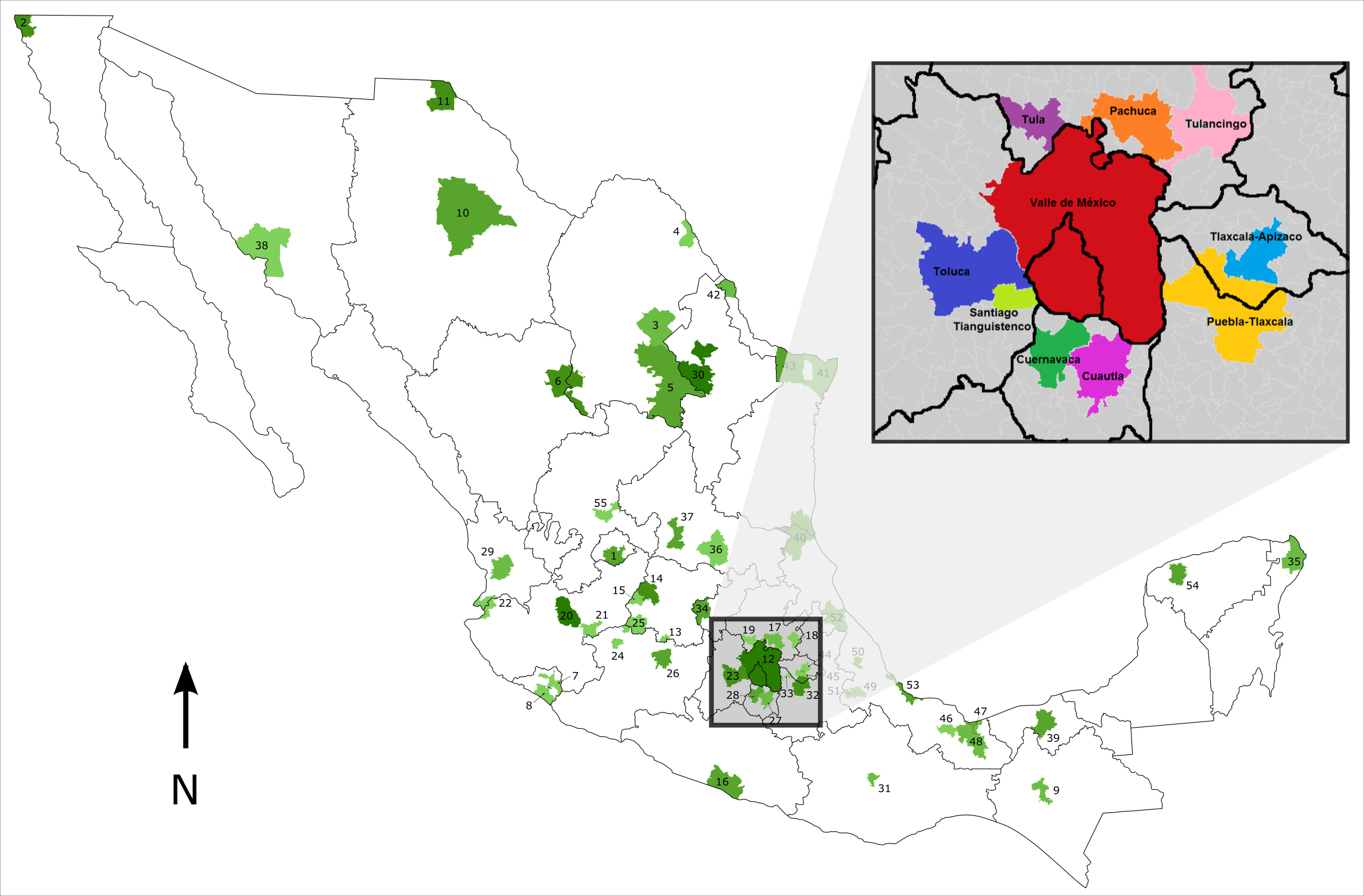
Português: Mapa de localização da Megalópole do México. |
| Data | (UTC) |
| Jatorria |
Fitxategi hau hemendik eratorria izan da: |
| Egilea |
| This is a retouched picture, which means that it has been digitally altered from its original version. The original can be viewed here: Metropolitan Areas of Mexico.svg:
|
Lizentzia
Luan, lan honen egileak, argitaratu du edo argitaratzen du ondorengo lizentzia pean:
This file is licensed under the Creative Commons Attribution-Share Alike 3.0 Brazil license.
Aitortu: Luan
- Askea zara:
- partekatzeko – lana kopiatzeko, banatzeko eta bidaltzeko
- birnahasteko – lana moldatzeko
- Ondorengo baldintzen pean:
- eskuduntza – Egiletza behar bezala aitortu behar duzu, lizentzia ikusteko esteka gehitu, eta ea aldaketak egin diren aipatu. Era egokian egin behar duzu hori guztia, baina inola ere ez egileak zure lana edo zure erabilera babesten duela irudikatuz.
- berdin partekatu – Lan honetan oinarrituta edo aldatuta berria eraikitzen baduzu, emaitza lana hau bezalako lizentzia batekin argitaratu behar duzu.


|
I'd greatly appreciate, that you attribute this media file to Wikimedia Commons, if used outside Wikipedia or Commons. For use in publications such as books, newspapers, blogs, websites, please insert here the following line:
Attribution: Luan
|
Jatorrizko igoera erregistroa
This image is a derivative work of the following images:
- File:Metropolitan Areas of Mexico.svg licensed with Cc-by-2.5, Cc-by-sa-3.0-migrated-with-disclaimers, GFDL-disclaimers, GFDL-with-disclaimers
- 2010-08-21T11:50:30Z File Upload Bot (Magnus Manske) 2282x1500 (859071 Bytes) {{BotMoveToCommons|en.wikipedia|year={{subst:CURRENTYEAR}}|month={{subst:CURRENTMONTHNAME}}|day={{subst:CURRENTDAY}}}} {{Information |Description={{en|This map gives the location of the 55 [[:en:Metropolitan Area|]]s identif
- File:Megapolis Mexico Nombres.png licensed with Cc-by-sa-4.0
Uploaded with derivativeFX
Fitxategiaren historia
Data/orduan klik egin fitxategiak orduan zuen itxura ikusteko.
| Data/Ordua | Iruditxoa | Neurriak | Erabiltzailea | Iruzkina | |
|---|---|---|---|---|---|
| oraingoa | 04:35, 7 maiatza 2018 | | 2.282 × 1.500 (681 KB) | Luan | == {{int:filedesc}} == {{Information |Description={{pt|Mapa de localização da Megalópole do México.}} |Source={{Derived from|Metropolitan Areas of Mexico.svg|Megapolis Mexico Nombres.png|display=50}} |Date=2018-05-07 02:33 (UTC) |Author=* File:Metropolitan Areas of Mexico.svg: {{user at project|Rune.welsh|wikipedia|en}} * File:Megapolis Mexico Nombres.png: AntoFran * derivative work: [[User:{{s... |
Irudira dakarten loturak
Hurrengo orrialdeek dute fitxategi honetarako lotura:
Fitxategiaren erabilera orokorra
Hurrengo beste wikiek fitxategi hau darabilte:
- es.wikipedia.org proiektuan duen erabilera
- gl.wikipedia.org proiektuan duen erabilera
- pt.wikipedia.org proiektuan duen erabilera
- www.wikidata.org proiektuan duen erabilera