
Fitxategi:Moorea et Tahiti vues par Sentinel 2.jpg

Bereizmen handikoa ((5.000 × 3.774 pixel, fitxategiaren tamaina: 5,46 MB, MIME mota: image/jpeg))
Fitxategi hau Wikimedia Commonsekoa da. Hango deskribapen orriko informazioa behean duzu. |
Laburpena
| Deskribapena |
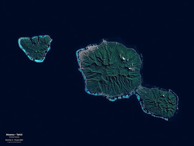
English: L'ile de Moorea vue par le satellite Sentinel 2, le 21 juin 2021.
Moorea est une ile du Pacifique Sud situee dans l'archipel de la Societe en Polynesie francaise. Elle est connue pour ses sommets volcaniques abrupts et ses plages de sable. La mission Sentinel-2 fait partie du programme d’observation et de surveillance de la Terre, Copernicus, conduit par l'Union Europeenne. Grace aux 2 satellites Sentinel-2A (2015) et Sentinel-2B (2017), tous les 5 jours, la mission Sentinel-2 fournit des cliches de notre planete. Objectifs : suivre a haute resolution l'evolution de la vegetation, de l'occupation des sols et l'impact du rechauffement climatique avec une haute frequence d’observations. |
| Data | |
| Jatorria | https://phototheque.cnes.fr/cnes/media/69129 |
| Egilea | European Space Agency / CNES |
| Beste bertsioak |
.jpg)
.jpg)
Lizentzia

|
This image contains data from a satellite in the Copernicus Programme, such as Sentinel-1, Sentinel-2 or Sentinel-3. Attribution is required when using this image.
Aitortu: Contains modified Copernicus Sentinel data 2021
The use of Copernicus Sentinel Data is regulated under EU law (Commission Delegated Regulation (EU) No 1159/2013 and Regulation (EU) No 377/2014). Relevant excerpts:
Free access shall be given to GMES dedicated data [...] made available through GMES dissemination platforms [...].
Access to GMES dedicated data [...] shall be given for the purpose of the following use in so far as it is lawful:
GMES dedicated data [...] may be used worldwide without limitations in time.
GMES dedicated data and GMES service information are provided to users without any express or implied warranty, including as regards quality and suitability for any purpose. |
Fitxategiaren historia
Data/orduan klik egin fitxategiak orduan zuen itxura ikusteko.
| Data/Ordua | Iruditxoa | Neurriak | Erabiltzailea | Iruzkina | |
|---|---|---|---|---|---|
| oraingoa | 16:03, 26 maiatza 2022 | | 5.000 × 3.774 (5,46 MB) | Don-vip | Uploaded a work by European Space Agency / CNES from https://phototheque.cnes.fr/cnes/media/69129 with UploadWizard |
Irudira dakarten loturak
Ez dago fitxategi hau darabilen orririk.