
Fitxategi:NATO partnerships.svg

SVG fitxategi honen PNG aurreikuspenaren tamaina: 800 × 360 pixel. Bestelako bereizmenak: 320 × 144 pixel | 640 × 288 pixel | 1.024 × 461 pixel | 1.280 × 576 pixel | 2.560 × 1.152 pixel.
Bereizmen handikoa (SVG fitxategia, nominaldi 800 × 360 pixel, fitxategiaren tamaina: 1,6 MB)
Fitxategi hau Wikimedia Commonsekoa da. Hango deskribapen orriko informazioa behean duzu. |
Laburpena
| Deskribapena |
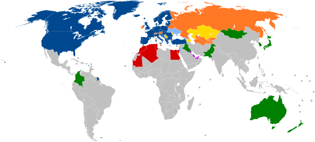
English: A global map of NATO partners around the world (with all the sovereign states that are under 20,000 km2 in area represented by a circle)
NATO member states Accession protocol signed Enhanced Opportunities Partner[1] Partnership for Peace (PfP) Français : Carte montrant les affiliations actuelles des pays européens avec l'OTAN. Les pays de moins de 20000 km2 sont représentés par un cercle.
Membres actuels Protocole d'adhésion signé Plan d'action pour l'adhésion Partenaire d'opportunités améliorées Partenariat pour la paix (PfP) Partenariat dans le monde
Português: Mapa mostrando as afiliações atuais dos países europeus com a OTAN. Os países com menos de 20.000 km2 são representados por um círculo.
Estados-membros da NATO Protocolo de Adesão Assinado Plano de Ação de Adesão Parceiros de Oportunidades Alargadas Plano de Ação de Adesão Individual Parceria para a Paz Diálogo do Mediterrâneo Iniciativa de Cooperação de Istambul Parceiros globais |
| Data | |
| Jatorria |
Fitxategi hau hemendik eratorria izan da: NATO cooperations partners.svg: |
| Egilea | Patrick |
| Beste bertsioak |
Derivative works of this file: Peak positions of Adele's 21 in worldwide charts.svg Derivative works of this file: NATO partnerships - 2.svg |
| SVG genesis | Fitxategi hau (bektore-irudia) hau Inkscape-ekin sortu da .
. |
Notes
- ↑ Partnership Interoperability Initiative. NATO (22 February 2022). Retrieved on 23 March 2022.
Lizentzia
Nik, lan honen egileak, argitaratzen dut ondorengo lizentzia pean:
Fitxategi hau Creative Commons Attribution-Share Alike 3.0 Unported lizentziapean dago.
- Askea zara:
- partekatzeko – lana kopiatzeko, banatzeko eta bidaltzeko
- birnahasteko – lana moldatzeko
- Ondorengo baldintzen pean:
- eskuduntza – Egiletza behar bezala aitortu behar duzu, lizentzia ikusteko esteka gehitu, eta ea aldaketak egin diren aipatu. Era egokian egin behar duzu hori guztia, baina inola ere ez egileak zure lana edo zure erabilera babesten duela irudikatuz.
- berdin partekatu – Lan honetan oinarrituta edo aldatuta berria eraikitzen baduzu, emaitza lana hau bezalako lizentzia batekin argitaratu behar duzu.
Jatorrizko igoera erregistroa
This image is a derivative work of the following images:
- NATO cooperations partners.svg licensed with Cc-by-sa-3.0
- 2012-02-06T21:37:21Z Patrickneil 800x360 (1681649 Bytes) Kosovo in gray
- 2012-02-06T21:34:07Z Patrickneil 800x360 (1681641 Bytes) Forgot Finland and Sweden
- 2012-02-06T21:26:54Z Patrickneil 800x360 (1692374 Bytes) Darker gray for non-affiliated countries
- 2012-02-06T21:23:31Z Patrickneil 800x360 (1682546 Bytes) trimming some of Micronesia for standard width of 800px
- 2012-02-06T21:11:00Z Patrickneil 842x358 (1688505 Bytes) == {{int:filedesc}} == {{Information |Description={{en|1=A global map of the world, with all the [[:en:List of countries and outlying territories by total area|sovereign states that are under 20,000 km2 in area]] represented
Uploaded with derivativeFX
Fitxategiaren historia
Data/orduan klik egin fitxategiak orduan zuen itxura ikusteko.
| Data/Ordua | Iruditxoa | Neurriak | Erabiltzailea | Iruzkina | |
|---|---|---|---|---|---|
| oraingoa | 17:45, 7 martxoa 2024 | | 800 × 360 (1,6 MB) | Janitoalevic | Sweden added |
| 23:59, 3 apirila 2023 |  | 800 × 360 (1,6 MB) | Louloumra59 | FIN | |
| 18:00, 3 apirila 2023 |  | 800 × 360 (1,6 MB) | CD967119 | They will join Tuesday, not today. | |
| 17:13, 3 apirila 2023 |  | 800 × 360 (1,6 MB) | Edroeh | FIN | |
| 16:02, 31 martxoa 2023 |  | 800 × 360 (1,6 MB) | Invinciblewalnut | Reverted to version as of 07:57, 10 August 2022 (UTC) | |
| 15:39, 31 martxoa 2023 |  | 800 × 360 (1,55 MB) | Invinciblewalnut | changed color of sweden and finland to reflect ongoing accession process | |
| 09:57, 10 abuztua 2022 |  | 800 × 360 (1,6 MB) | Zarwada | == {{int:filedesc}} == {{Information |Description={{en|1=A global map of NATO partners around the world, with all the {{W|List of countries and outlying territories by total area|sovereign states that are under 20,000 km<sup>2</sup> in area}} represented by a circle. {{legtab|#004990 thin solid transparent|NATO {{W|Member states of NATO|member}} states |#2A7FFF thin solid transparent|{{W|Membership Action Plan}} |#88B7FF thin solid transparent|Enhanced Opportunities Partner<ref>{{cite web |... | |
| 21:43, 24 uztaila 2022 |  | 800 × 360 (1,6 MB) | Kwamikagami | rs. recent fixes, rm. non-countries | |
| 21:21, 24 uztaila 2022 |  | 800 × 360 (1,6 MB) | Kwamikagami | restore Kosovo - Reverted to version as of 16:21, 27 March 2020 (UTC) | |
| 11:29, 22 uztaila 2022 |  | 2.754 × 1.398 (1,09 MB) | Kwamikagami | NATO blue, #004990 |
Irudira dakarten loturak
Hurrengo orrialdeek dute fitxategi honetarako lotura:
Fitxategiaren erabilera orokorra
Hurrengo beste wikiek fitxategi hau darabilte:
- af.wikipedia.org proiektuan duen erabilera
- ar.wikipedia.org proiektuan duen erabilera
- حلف شمال الأطلسي
- حوار متوسطي
- الشراكة من أجل السلام
- علاقات حلف الناتو الخارجية
- قالب:علاقات حلف الناتو
- جمعية حلف الأطلسي
- مجلس الشراكة الأوروبية الأطلسية
- مبادرة اسطنبول للتعاون
- العلاقات بين روسيا وحلف شمال الأطلسي
- علاقات ألبانيا والناتو
- العلاقات بين أوكرانيا وحلف الناتو
- العلاقات بين جورجيا والناتو
- انضمام البوسنة والهرسك إلى الناتو
- العلاقات بين السويد وحلف الناتو
- العلاقات بين النمسا وحلف الناتو
- ast.wikipedia.org proiektuan duen erabilera
- az.wikipedia.org proiektuan duen erabilera
- be-tarask.wikipedia.org proiektuan duen erabilera
- bg.wikipedia.org proiektuan duen erabilera
- ca.wikipedia.org proiektuan duen erabilera
- cs.wikipedia.org proiektuan duen erabilera
- da.wikipedia.org proiektuan duen erabilera
- de.wikipedia.org proiektuan duen erabilera
- el.wikipedia.org proiektuan duen erabilera
- en.wikipedia.org proiektuan duen erabilera
- NATO
- Euro-Atlantic Partnership Council
- Partnership for Peace
- Atlantic Treaty Association
- Mediterranean Dialogue
- Individual Partnership Action Plan
- Istanbul Cooperation Initiative
- Georgia–NATO relations
- Romania in NATO
- Canada in NATO
- Ukraine–NATO relations
- Russia–NATO relations
- Talk:NATO
- Croatia–NATO relations
- Albania–NATO relations
- Montenegro–NATO relations
- North Macedonia–NATO relations
- Template:NATO relations
- Talk:NATO/Archive 3
- Moldova–NATO relations
- Bosnia and Herzegovina–NATO relations
- NATO logistics in the Afghan War
- User:Patrickneil/NATO
- Foreign relations of NATO
- Pakistan–NATO relations
Ikus fitxategi honen erabilpen global gehiago.