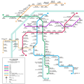
Fitxategi:Nanjing Metro map.svg

SVG fitxategi honen PNG aurreikuspenaren tamaina: 600 × 600 pixel. Bestelako bereizmenak: 240 × 240 pixel | 480 × 480 pixel | 768 × 768 pixel | 1.024 × 1.024 pixel | 2.048 × 2.048 pixel | 5.800 × 5.800 pixel.
Bereizmen handikoa (SVG fitxategia, nominaldi 5.800 × 5.800 pixel, fitxategiaren tamaina: 336 KB)
Fitxategiaren historia
Data/orduan klik egin fitxategiak orduan zuen itxura ikusteko.
| Data/Ordua | Iruditxoa | Neurriak | Erabiltzailea | Iruzkina | |
|---|---|---|---|---|---|
| oraingoa | 08:45, 6 urtarrila 2022 |  | 5.800 × 5.800 (336 KB) | Haha169 | update line S6 and line 2 |
| 13:52, 30 maiatza 2021 |  | 5.800 × 5.800 (314 KB) | Tomchen1989 | fix Caochangmen's position | |
| 13:34, 30 maiatza 2021 |  | 5.800 × 5.800 (327 KB) | Tomchen1989 | fix font for "x号线" | |
| 13:28, 30 maiatza 2021 |  | 5.800 × 5.800 (327 KB) | Tomchen1989 | Change date | |
| 13:19, 30 maiatza 2021 |  | 5.800 × 5.800 (327 KB) | Tomchen1989 | fix File talk:NJmetro20150401.png#明发广场 and 徐庄 File talk:Nanjing Metro map.svg#柘塘; fix "·" placement; check with the [https://www.njmetro.com.cn/njdtweb/home/go-operate-center.do?tag=czjj official map] | |
| 09:51, 9 maiatza 2019 |  | 5.800 × 5.800 (329 KB) | Haha169 | Minor fixes | |
| 04:36, 28 maiatza 2018 |  | 5.800 × 5.800 (329 KB) | Haha169 | Line S7 opening | |
| 07:04, 30 abendua 2017 |  | 5.800 × 5.800 (309 KB) | Haha169 | S9 line opens | |
| 18:17, 5 abendua 2017 |  | 5.800 × 5.800 (297 KB) | Haha169 | Line S3 has opened | |
| 18:12, 10 otsaila 2017 |  | 5.000 × 5.000 (261 KB) | SSYoung | (Another) station name fixed |
Irudira dakarten loturak
Ez dago fitxategi hau darabilen orririk.
Fitxategiaren erabilera orokorra
Hurrengo beste wikiek fitxategi hau darabilte:
- ca.wikipedia.org proiektuan duen erabilera
- en.wikibooks.org proiektuan duen erabilera
- en.wikivoyage.org proiektuan duen erabilera
- hu.wikipedia.org proiektuan duen erabilera
- it.wikivoyage.org proiektuan duen erabilera
- pl.wikivoyage.org proiektuan duen erabilera
- ru.wikipedia.org proiektuan duen erabilera


