
Fitxategi:Nepkoztarsasag.png
Ez dago bereizmen handiagorik.
Nepkoztarsasag.png ((660 × 428 pixel, fitxategiaren tamaina: 55 KB, MIME mota: image/png))
Fitxategi hau Wikimedia Commonsekoa da. Hango deskribapen orriko informazioa behean duzu. |
Accuracy
Laburpena
| Deskribapena |
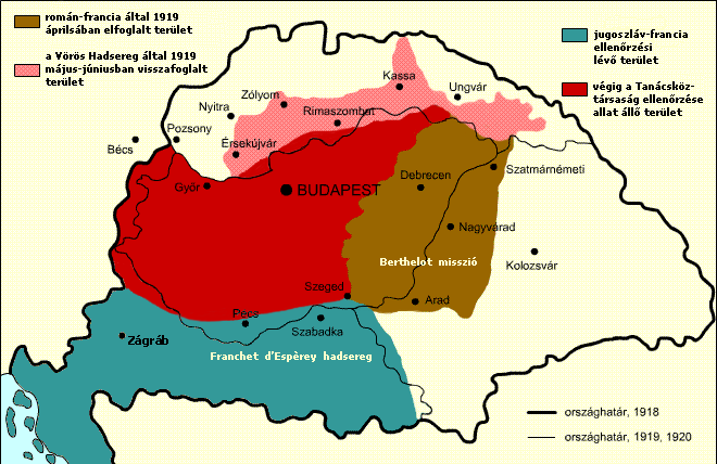
English: Military success of the Hungarian Soviet Republic Territory under Romanian and French control in April, 1919 Territory under the control of the Hungarian Soviet Republic Territory recovered by the Hungarian Soviet Republic Territory under French and Yugoslav control
Italiano: Situazione territoriale della Repubblica sovietica ungherese Territori sotto il controllo rumeno e francese nell'aprile 1919 Territori sotto il controllo della Repubblica sovietica ungherese Territori riconquistati dalla Repubblica sovietica ungherese Territori sotto il controllo francese e jugoslavo
Español: Situación territorial durante el periodo de la República Soviética Húngara Territorio bajo control rumano-francés en abril de 1919. Territorio originalmente bajo control de la República Soviética Húngara Territorio recuperado por la República a Checoslovaquia Territorio bajo control franco-yugoslavo |
| Data | |
| Jatorria |
Transferred from hu.wikipedia to Commons. The original description page was here. All following user names refer to hu.wikipedia. |
| Egilea | Kovács Ádám |
| Beste bertsioak | Derivative works of this file: RepúblicaSoviéticaHúngara1919.svg; Georgian Version SVG |
Lizentzia
This file is licensed under the Creative Commons Attribution-Share Alike 2.5 Generic license.
- Askea zara:
- partekatzeko – lana kopiatzeko, banatzeko eta bidaltzeko
- birnahasteko – lana moldatzeko
- Ondorengo baldintzen pean:
- eskuduntza – Egiletza behar bezala aitortu behar duzu, lizentzia ikusteko esteka gehitu, eta ea aldaketak egin diren aipatu. Era egokian egin behar duzu hori guztia, baina inola ere ez egileak zure lana edo zure erabilera babesten duela irudikatuz.
- berdin partekatu – Lan honetan oinarrituta edo aldatuta berria eraikitzen baduzu, emaitza lana hau bezalako lizentzia batekin argitaratu behar duzu.
Fitxategiaren historia
Data/orduan klik egin fitxategiak orduan zuen itxura ikusteko.
| Data/Ordua | Iruditxoa | Neurriak | Erabiltzailea | Iruzkina | |
|---|---|---|---|---|---|
| oraingoa | 15:15, 22 azaroa 2017 | | 660 × 428 (55 KB) | Julieta39 | Diacritic corrected |
| 14:04, 22 azaroa 2017 |  | 660 × 428 (55 KB) | Julieta39 | According with "Történelmi atlasz", Kartográfiai Vállalat, Budapest 1989, ISBN 9633514223 CM | |
| 13:08, 9 otsaila 2011 |  | 660 × 428 (47 KB) | Hobartimus~commonswiki | Reverted to version as of 18:15, 6 February 2011 | |
| 02:20, 9 otsaila 2011 |  | 660 × 428 (23 KB) | Lovech~commonswiki | returning to the superior original version | |
| 20:15, 6 otsaila 2011 |  | 660 × 428 (47 KB) | 123iti | reverted unexplained edit | |
| 18:40, 5 otsaila 2011 |  | 660 × 428 (23 KB) | Lovech~commonswiki | Reverted to version as of 22:33, 28 December 2010 | |
| 02:17, 29 abendua 2010 |  | 660 × 428 (47 KB) | 123iti | ok, then I am proposing this compromise version due to my discussion page explanation | |
| 00:33, 29 abendua 2010 |  | 660 × 428 (23 KB) | VT | Reverted to version as of 13:20, 20 May 2009 -> this version is right, then those territories were under occupation | |
| 13:53, 6 abendua 2010 |  | 660 × 428 (35 KB) | 123iti | There is no reason that vojvodina is colored here because it had no any relation with Hungarian Soviet Republic. See source: http://libcom.org/files/images/library/hungarianmap%5B1%5D.jpg (Transylvania, Slovakia and Transcarpathia are not colored too, so | |
| 15:20, 20 maiatza 2009 |  | 660 × 428 (23 KB) | Baxter9~commonswiki | {{Information |Description={{en|1=Military succes of the Hungarian Soviet Republic}} |Source=http://hu.wikipedia.org/wiki/F%C3%A1jl:Nepkoztarsasag.png |Author=Kovács Ádám |Date=2006 |Permission= |other_versions= }} <!--{{ImageUpload|full}}--> [[Catego |
Irudira dakarten loturak
Hurrengo orrialdeek dute fitxategi honetarako lotura:
Fitxategiaren erabilera orokorra
Hurrengo beste wikiek fitxategi hau darabilte:
- ar.wikipedia.org proiektuan duen erabilera
- ast.wikipedia.org proiektuan duen erabilera
- azb.wikipedia.org proiektuan duen erabilera
- az.wikipedia.org proiektuan duen erabilera
- be.wikipedia.org proiektuan duen erabilera
- bg.wikipedia.org proiektuan duen erabilera
- cbk-zam.wikipedia.org proiektuan duen erabilera
- cs.wikipedia.org proiektuan duen erabilera
- da.wikipedia.org proiektuan duen erabilera
- el.wikipedia.org proiektuan duen erabilera
- en.wikipedia.org proiektuan duen erabilera
- eo.wikipedia.org proiektuan duen erabilera
- et.wikipedia.org proiektuan duen erabilera
- fa.wikipedia.org proiektuan duen erabilera
- fr.wikipedia.org proiektuan duen erabilera
- gl.wikipedia.org proiektuan duen erabilera
- hr.wikipedia.org proiektuan duen erabilera
- hu.wikipedia.org proiektuan duen erabilera
- hy.wikipedia.org proiektuan duen erabilera
- id.wikipedia.org proiektuan duen erabilera
- it.wikipedia.org proiektuan duen erabilera
- ja.wikipedia.org proiektuan duen erabilera
- ka.wikipedia.org proiektuan duen erabilera
- kk.wikipedia.org proiektuan duen erabilera
- ko.wikipedia.org proiektuan duen erabilera
- la.wikipedia.org proiektuan duen erabilera
Ikus fitxategi honen erabilpen global gehiago.