
Fitxategi:Nevado del Ruiz Volcano, Colombia.jpg

Aurreikuspen honen neurria: 800 × 526 pixel. Bestelako bereizmenak: 320 × 211 pixel | 640 × 421 pixel | 1.024 × 674 pixel | 1.280 × 842 pixel | 2.560 × 1.684 pixel | 4.256 × 2.800 pixel.
Bereizmen handikoa ((4.256 × 2.800 pixel, fitxategiaren tamaina: 7,73 MB, MIME mota: image/jpeg))
Fitxategi hau Wikimedia Commonsekoa da. Hango deskribapen orriko informazioa behean duzu. |
Laburpena
| Deskribapena |
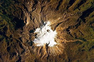
English: In this photo, the volcano’s summit and upper flanks are covered by several glaciers that appear as a white mass surrounding the 1-kilometre-wide Arenas Crater; melt-water from these glaciers has incised the grey to tan ash and pyroclastic flow deposits mantling the lower slopes. A well-defined lava flow is visible at image lower right. This astronaut photograph was taken at approximately 7:45 a.m. local time, when the Sun was still fairly low above the horizon, leading to shadowing to the west of topographic high points. |
| Data | |
| Jatorria | NASA Earth Obseravatory |
| Egilea | The NASA Expedition 23 crew |
| Kameraren kokapena | | Irudi hau eta gehiago beraien kokapenekin hurrengo lekuetan: OpenStreetMap |
|---|
This image or video was catalogued by Johnson Space Center of the United States National Aeronautics and Space Administration (NASA) under Photo ID: ISS023-E-27737. This tag does not indicate the copyright status of the attached work. A normal copyright tag is still required. See Commons:Licensing. Other languages:
|
Image acquired with a Nikon D3S digital camera fitted with an 800 mm lens, and is provided by the ISS Crew Earth Observations experiment and Image Science & Analysis Laboratory, Johnson Space Center.
Lizentzia
| This file is in the public domain in the United States because it was solely created by NASA. NASA copyright policy states that "NASA material is not protected by copyright unless noted". (See Template:PD-USGov, NASA copyright policy page or JPL Image Use Policy.) | ||
 |
Warnings:
|
| Annotations | This image is annotated: View the annotations at Commons |
Fitxategiaren historia
Data/orduan klik egin fitxategiak orduan zuen itxura ikusteko.
| Data/Ordua | Iruditxoa | Neurriak | Erabiltzailea | Iruzkina | |
|---|---|---|---|---|---|
| oraingoa | 12:10, 3 maiatza 2010 | | 4.256 × 2.800 (7,73 MB) | Originalwana | {{Information |Description={{en|1=In this photo, the volcano’s summit and upper flanks are covered by several glaciers that appear as a white mass surrounding the 1-kilometre-wide Arenas Crater; melt-water from these glac |
Irudira dakarten loturak
Hurrengo orrialdeek dute fitxategi honetarako lotura:
Fitxategiaren erabilera orokorra
Hurrengo beste wikiek fitxategi hau darabilte:
- ast.wikipedia.org proiektuan duen erabilera
- avk.wikipedia.org proiektuan duen erabilera
- ca.wikipedia.org proiektuan duen erabilera
- en.wikipedia.org proiektuan duen erabilera
- en.wikiversity.org proiektuan duen erabilera
- es.wikipedia.org proiektuan duen erabilera
- fr.wikipedia.org proiektuan duen erabilera
- he.wikipedia.org proiektuan duen erabilera
- id.wikipedia.org proiektuan duen erabilera
- it.wikipedia.org proiektuan duen erabilera
- ka.wikipedia.org proiektuan duen erabilera
- mk.wikipedia.org proiektuan duen erabilera
- nl.wikipedia.org proiektuan duen erabilera
- pt.wikipedia.org proiektuan duen erabilera
- sl.wikipedia.org proiektuan duen erabilera
- sr.wikipedia.org proiektuan duen erabilera