
Fitxategi:Porthloo beach, St Mary's, Scilly - geograph.org.uk - 1607577.jpg
Ez dago bereizmen handiagorik.
Porthloo_beach,_St_Mary's,_Scilly_-_geograph.org.uk_-_1607577.jpg ((640 × 383 pixel, fitxategiaren tamaina: 83 KB, MIME mota: image/jpeg))
Fitxategi hau Wikimedia Commonsekoa da. Hango deskribapen orriko informazioa behean duzu. |
Laburpena
| Deskribapena |
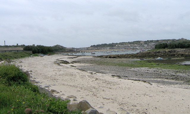
English: Porthloo beach, St Mary's, Scilly Porthloo has a nice sandy upper beach, but the middle shore is mainly occupied by shingle, rocks and weed. Not good for swimming, but from the seats nearby, you can watch shorebirds foraging amongst the rocks and weed. In the middle distance is the launching ramp for the St Mary's lifeboat at Carn Thomas. Beyond and to the right is St Mary's Pool, with many boats moored. The island to the middle right is Newford Island. The land to the upper right is the Garrison. |
| Data | |
| Jatorria | From geograph.org.uk |
| Egilea | John Rostron |
| Aitortu (required by the license) | John Rostron / Porthloo beach, St Mary's, Scilly / |
| Kameraren kokapena | | Irudi hau eta gehiago beraien kokapenekin hurrengo lekuetan: OpenStreetMap |
|---|
_heading:202.00&language=eu)
| Objektuaren kokapena | | Irudi hau eta gehiago beraien kokapenekin hurrengo lekuetan: OpenStreetMap |
|---|
_heading:202.00&language=eu)
Lizentzia

|
This image was taken from the Geograph project collection. See this photograph's page on the Geograph website for the photographer's contact details. The copyright on this image is owned by John Rostron and is licensed for reuse under the Creative Commons Attribution-ShareAlike 2.0 license.
|
This file is licensed under the Creative Commons Attribution-Share Alike 2.0 Generic license.
Aitortu: John Rostron
- Askea zara:
- partekatzeko – lana kopiatzeko, banatzeko eta bidaltzeko
- birnahasteko – lana moldatzeko
- Ondorengo baldintzen pean:
- eskuduntza – Egiletza behar bezala aitortu behar duzu, lizentzia ikusteko esteka gehitu, eta ea aldaketak egin diren aipatu. Era egokian egin behar duzu hori guztia, baina inola ere ez egileak zure lana edo zure erabilera babesten duela irudikatuz.
- berdin partekatu – Lan honetan oinarrituta edo aldatuta berria eraikitzen baduzu, emaitza lana hau bezalako lizentzia batekin argitaratu behar duzu.
Fitxategiaren historia
Data/orduan klik egin fitxategiak orduan zuen itxura ikusteko.
| Data/Ordua | Iruditxoa | Neurriak | Erabiltzailea | Iruzkina | |
|---|---|---|---|---|---|
| oraingoa | 09:08, 4 martxoa 2011 | | 640 × 383 (83 KB) | GeographBot | == {{int:filedesc}} == {{Information |description={{en|1=Porthloo beach, St Mary's, Scilly Porthloo has a nice sandy upper beach, but the middle shore is mainly occupied by shingle, rocks and weed. Not good for swimming, but from the seats nearby, you can |
Irudira dakarten loturak
Hurrengo orrialdeek dute fitxategi honetarako lotura:
Fitxategiaren erabilera orokorra
Hurrengo beste wikiek fitxategi hau darabilte:
- en.wikipedia.org proiektuan duen erabilera
- gd.wikipedia.org proiektuan duen erabilera
- hy.wikipedia.org proiektuan duen erabilera
- pl.wikipedia.org proiektuan duen erabilera
- www.wikidata.org proiektuan duen erabilera