
Fitxategi:Reichskanzlei-Fuehrerbunker.jpg

Bereizmen handikoa ((2.599 × 3.500 pixel, fitxategiaren tamaina: 1,76 MB, MIME mota: image/jpeg))
Fitxategi hau Wikimedia Commonsekoa da. Hango deskribapen orriko informazioa behean duzu. |
| Deskribapena |
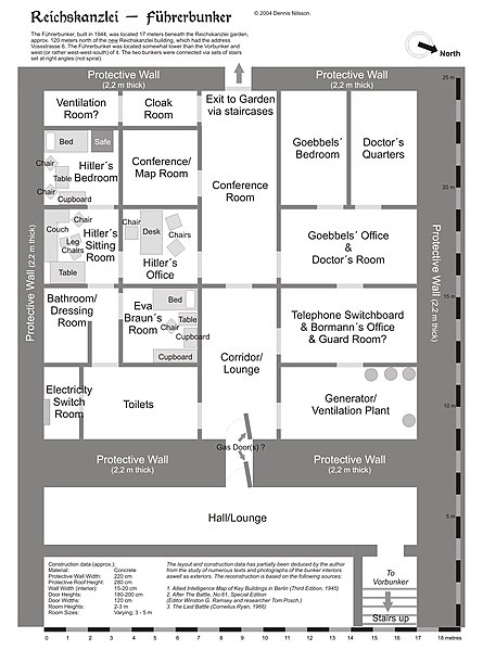
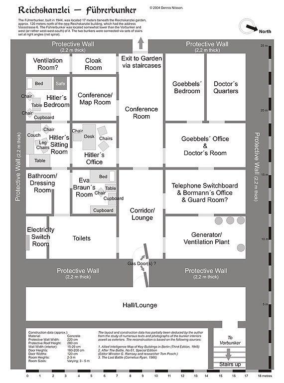
Map of the Fuehrerbunker in Berlin, 1945. |
| Data | |
| Jatorria | Norberak egina |
| Egilea | User:Dna-Dennis |
| Lizentzia (Fitxategi hau berrerabiltzen) |
GFDL (see below) |
| Beste bertsioak | Image:Reichskanzlei-Fuehrerbunker.png, Image:Reichskanzlei-Fuehrerbunker.svg (language neutral version in color) |
Lizentzia
- Askea zara:
- partekatzeko – lana kopiatzeko, banatzeko eta bidaltzeko
- birnahasteko – lana moldatzeko
- Ondorengo baldintzen pean:
- eskuduntza – Egiletza behar bezala aitortu behar duzu, lizentzia ikusteko esteka gehitu, eta ea aldaketak egin diren aipatu. Era egokian egin behar duzu hori guztia, baina inola ere ez egileak zure lana edo zure erabilera babesten duela irudikatuz.
- berdin partekatu – Lan honetan oinarrituta edo aldatuta berria eraikitzen baduzu, emaitza lana hau bezalako lizentzia batekin argitaratu behar duzu.
I hereby release this image with the following declaration:
Reproduction and distribution is allowed and encouraged as long as the author is acknowledged by name when this image is used.
Laburpena
This is a map of the Fuehrerbunker in Berlin, 1945. The layout is not necessarily perfectly exact, but it is very probable. There were two bunkers which were connected - the Fuehrerbunker and the Vorbunker, and here is the link to my map of the Vorbunker, and a link to my map showing the locations of the Fuehrerbunker and Vorbunker in Berlin, 1945.
Information about the details of the bunkers is rather scarce, which is not strange, since the bunkers were secret. This map is based on the excellent research of Tom Posch (see below), who visited and photographed the remains from inside in 1988. He concluded that the map of the bunker in Cornelius Ryan's The Last Battle was incorrect, and a new, hand-drawn map of the Vorbunker was produced by Tom Posch.
Location notes
The Fuehrerbunker, built in 1944, was located 8-17 meters beneath the Reichskanzlei garden, approx. 120 meters north of the new Reichskanzlei building, which had the address Vossstrasse 6. The Führerbunker was located somewhat lower than the Vorbunker and west (or rather west-west-south) of it. The two bunkers were connected via sets of stairs set at right angles (not spiral).
Layout notes
- Particularly uncertain items are marked with question marks.
- The positions of the furniture in Hitler's and Eva Braun's rooms are deduced from various photographs of the interiors and oral accounts.
- The exact position of water & ventilation facilites and showers are uncertain. Whether the entrance to the Fuehrerbunker had one or two, or any, gas doors is also uncertain.
Construction data (approximates)
- Material: Concrete
- Protective Wall Width: 220 cm
- Protective Roof Height: 280 cm
- Wall Width (interior): 15-20 cm
- Door Heights: 180-200 cm
- Door Widths: 120 cm
- Room Heights: 2-3 m
- Room Sizes: Varying; 3-5 m
References
The map is based on the following sources:
- Ramsey, Winston G. (editor) & Posch, Tom (researcher), The Berlin Führerbunker: The Thirteenth Hole, After the Battle archive copy at the Wayback Machine, No.61, Special Edition, Battle of Britain International Ltd, 1988, London
- Allied Intelligence Map of Key Buildings in Berlin (3rd edition, 1945)
- Ryan, Cornelius, The Last Battle (1966)
Regards, Dennis Nilsson, Sweden.
If you wish to contact me, please leave a message on my talk page.
Fitxategiaren historia
Data/orduan klik egin fitxategiak orduan zuen itxura ikusteko.
| Data/Ordua | Iruditxoa | Neurriak | Erabiltzailea | Iruzkina | |
|---|---|---|---|---|---|
| oraingoa | 02:16, 14 abendua 2005 | | 2.599 × 3.500 (1,76 MB) | Dna-webmaster~commonswiki | |
| 05:44, 14 azaroa 2005 |  | 2.599 × 3.500 (1,82 MB) | Dna-webmaster~commonswiki |
Irudira dakarten loturak
Ez dago fitxategi hau darabilen orririk.
Fitxategiaren erabilera orokorra
Hurrengo beste wikiek fitxategi hau darabilte:
- en.wikipedia.org proiektuan duen erabilera
- fi.wikipedia.org proiektuan duen erabilera
- sl.wikipedia.org proiektuan duen erabilera