
Fitxategi:Rubjerg Knude Fyr, Hjørring, Denmark, 1807072231, ako.jpg

Bereizmen handikoa ((6.720 × 4.480 pixel, fitxategiaren tamaina: 5,56 MB, MIME mota: image/jpeg))
Fitxategi hau Wikimedia Commonsekoa da. Hango deskribapen orriko informazioa behean duzu. |
Laburpena
| Deskribapena |
Deutsch: Rubjerg Knude Fyr ist ein Leuchtturm zwischen Lønstrup und Løkken (Kommune Hjørring) in Nordjylland (Dänemark). Der Leuchtturm wurde im Jahr 1900 errichtet. Ab den 1910er Jahren bildete sich durch den Wind eine Düne zwischen dem Leuchtturm und dem Meer. Die Düne bewegt sich in Richtung Nordost und hat den Leuchtturm mittlerweile vollständig passiert. Von den Nebengebäuden sind nur noch lose Ziegelsteine vorhanden. Der Turm selbst wird vermutlich in nächster Zeit die Steilküste hinabstürzen. Die dänische Naturschutzbehörde will dem zuvorkommen und den Turm abreißen, bevor er in die Nordsee stürzt.
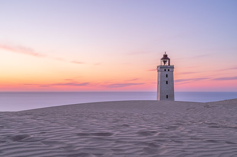
English: Rubjerg Knude Fyr is a lighthouse between Lønstrup and Løkken (municipality Hjørring) in Denmark which was built in 1900. From the 1910s, the wind blew large amounts of sand from the cliffs and the actual dune formed between the lighthouse and the sea. The dune moved towards northeast and now has completely passed the lighthouse. Of the outbuildings only loose bricks remains. The lighthouse was built 200 m from the coast, but the sea has since eaten into the 60 m high cliff so much that the lighthouse is now in grave danger of falling into the sea . It's now planned to move it 60-80 meters inland, which should protect it another 40-60 years.
日本語: Rubjerg Knude灯台 (英語) はデンマークの北ユラン地域LønstrupとLøkkenの間にある。1900年竣工。1910年代から灯台と海の間に形成された砂丘から風で砂が大量に吹き飛ばされ、砂丘が北東に移動した結果、今では灯台は完全に取り残された。外郭のうち剥がれ落ちたレンガのみ残された。灯台自体はまもなく崩壊すると予想されている。デンマークの自然保護当局は北海に崩落する前に建物を解体する計画である。
Polski: Latarnia morska Rubjerg Knude położona pomiędzy miejscowościami Lønstrup i Løkken w gminie Hjørring, w Danii. Latarnię zbudowano w latach 1899–1900. Od lat 10-tych XX wieku wiatr zaczął nanosić ogromne ilości piasku z klifów, w wyniku czego pomiędzy latarnią a morzem utworzyła się wydma. Wydma przemieszczała się w kierunku północno-wschodnim i już całkowicie „przetoczyła się” przez latarnię. Z otaczających budynków gospodarczych pozostały jedynie luźne cegły. Sama wieża prawdopodobnie zawali się w najbliższej przyszłości ze względu na postępującą erozję klifu. Duńskie władze ds. ochrony przyrody planują jej rozbiórkę zanim wpadnie ona do Morza Północnego.
Українська: Rubjerg Knude Fyr - це маяк між Lønstrup і Løkken (муніципалітет Hjørring) в Данії, який був побудований в 1900 році. Дюна рухалася на північний схід і тепер повністю пройшла через маяк. Від господарських будівель залишилися тільки цеглини, які розкидані довкола. Очікується, що сам маяк незабаром розвалиться. Датський природоохоронний орган планує розібрати будівлю, перш ніж вона впаде у північне море.
Čeština: Maják Rubjerg Knude Fyr mezi městy Lønstrup a Løkken na Severojutském ostrově v Dánsku byl postaven v roce 1900.
Español: Rubjerg Knude Fyr es un faro construido en 1900 entre Lønstrup y Løkken en Dinamarca. Desde la década de 1910, el viento sopló grandes cantidades de arena de los acantilados, formando una duna entre el faro y el mar. La duna se movió hacia el noreste y ahora ha pasado por completo el faro. De las dependencias del faro solo quedan ruinas de ladrillos sueltos. Se espera que el faro también colapse pronto. Las autoridades de la naturaleza danesa planean desmantelar el edificio antes de que caiga en ruinas en el mar del norte.
Magyar: Rubjerg Knude Fyr, egy 1900-ban épült világítótorony Lønstrup és Løkken között. Az 1910-es évektől a szél homokdűnét formált a világítótorony és a tenger közé. A dűne északnyugati irányú mozgásban van és mára túlhaladt a világítótornyon. A melléképületekből már csak egy halom tégla maradt. A tornyot a meredek parton a ledőlés fenyegeti. A dán természetvédelmi hatóság a világítótorony bontását tervezi, mielőtt az Északi-tengerbe dől (Hjørring község, Nordjylland régió, Dánia)
Македонски: Светилник на Северното Море во кај Јеринг, Данска. Изграден е во 1900 г. и денес е опкружен со наталожени песочни дини до степен на самоуривање. Предвидено е да се отстрани од местото пред да се сруши во морето.
Nederlands: De in 1900 gebouwde vuurtoren Rubjerg Knude Fyr tussen Lønstrup en Løkken in de Deense regio Noord-Jutland
Português: Rubjerg Knude Fyr, um farol construído em 1900 entre Lønstrup e Løkken na Dinamarca. A partir de 1910, o vento soprou grandes quantidades de areia das falésias, formando uma duna entre o farol e o mar. A duna se moveu para o nordeste e agora passou completamente pelo farol. Das dependências do farol só restaram tijolos soltos. É esperado que o farol venha abaixo em breve. As autoridades da natureza dinamarquesa planejam demolir o prédio antes que ele caia no Mar do Norte. |
||
| Data | |||
| Jatorria | Norberak egina | ||
| Egilea | Ansgar Koreng | ||
| Lizentzia (Fitxategi hau berrerabiltzen) |
|
||
| Beste bertsioak |
|
||
| Aitortu (required by the license) | Ansgar Koreng / | ||


| Kameraren kokapena | | Irudi hau eta gehiago beraien kokapenekin hurrengo lekuetan: OpenStreetMap |
|---|
Assessment
|

Irudi hau Eguneko irudi bezala hautatua izan da 2019ko uztailaren 7a-(e)an. Honela izan zen deskribatua: English: Rubjerg Knude Fyr is a lighthouse between Lønstrup and Løkken (municipality Hjørring) in Denmark which was built in 1900. From the 1910s, the wind blew large amounts of sand from the cliffs and an actual dune formed between the lighthouse and the sea. The dune moved northeast and now has completely passed the lighthouse. Of the outbuildings only loose bricks remain. The lighthouse itself is expected to collapse soon. The Danish nature authority is planning to dismantle the building before it is going to fall into the North Sea. Beste hizkuntzak:
Čeština: Maják Rubjerg Knude Fyr mezi městy Lønstrup a Løkken na Severojutském ostrově v Dánsku byl postaven v roce 1900. Deutsch: Rubjerg Knude Fyr ist ein Leuchtturm zwischen Lønstrup und Løkken (Kommune Hjørring) in Nordjylland (Dänemark). Der Leuchtturm wurde im Jahr 1900 errichtet. Ab den 1910er Jahren bildete sich durch den Wind eine Düne zwischen dem Leuchtturm und dem Meer. Die Düne bewegt sich in Richtung Nordost und hat den Leuchtturm mittlerweile vollständig passiert. Von den Nebengebäuden sind nur noch lose Ziegelsteine vorhanden. Der Turm selbst wird vermutlich in nächster Zeit die Steilküste hinabstürzen. Die dänische Naturschutzbehörde will dem zuvorkommen und den Turm abreißen, bevor er in die Nordsee stürzt. English: Rubjerg Knude Fyr is a lighthouse between Lønstrup and Løkken (municipality Hjørring) in Denmark which was built in 1900. From the 1910s, the wind blew large amounts of sand from the cliffs and an actual dune formed between the lighthouse and the sea. The dune moved northeast and now has completely passed the lighthouse. Of the outbuildings only loose bricks remain. The lighthouse itself is expected to collapse soon. The Danish nature authority is planning to dismantle the building before it is going to fall into the North Sea. Español: Rubjerg Knude Fyr es un faro construido en 1900 entre Lønstrup y Løkken en Dinamarca. Desde la década de 1910, el viento sopló grandes cantidades de arena de los acantilados, formando una duna entre el faro y el mar. La duna se movió hacia el noreste y ahora ha pasado por completo el faro. De las dependencias del faro solo quedan ruinas de ladrillos sueltos. Se espera que el faro también colapse pronto. Las autoridades de la naturaleza danesa planean desmantelar el edificio antes de que caiga en ruinas en el mar del norte. Magyar: Rubjerg Knude Fyr, egy 1900-ban épült világítótorony Lønstrup és Løkken között. Az 1910-es évektől a szél homokdűnét formált a világítótorony és a tenger közé. A dűne északnyugati irányú mozgásban van és mára túlhaladt a világítótornyon. A melléképületekből már csak egy halom tégla maradt. A tornyot a meredek parton a ledőlés fenyegeti. A dán természetvédelmi hatóság a világítótorony bontását tervezi, mielőtt az Északi-tengerbe dől (Hjørring község, Nordjylland régió, Dánia) Nederlands: De in 1900 gebouwde vuurtoren Rubjerg Knude Fyr tussen Lønstrup en Løkken in de Deense regio Noord-Jutland Polski: Latarnia morska Rubjerg Knude położona pomiędzy miejscowościami Lønstrup i Løkken w gminie Hjørring, w Danii. Latarnię zbudowano w latach 1899–1900. Od lat 10-tych XX wieku wiatr zaczął nanosić ogromne ilości piasku z klifów, w wyniku czego pomiędzy latarnią a morzem utworzyła się wydma. Wydma przemieszczała się w kierunku północno-wschodnim i już całkowicie „przetoczyła się” przez latarnię. Z otaczających budynków gospodarczych pozostały jedynie luźne cegły. Sama wieża prawdopodobnie zawali się w najbliższej przyszłości ze względu na postępującą erozję klifu. Duńskie władze ds. ochrony przyrody planują jej rozbiórkę zanim wpadnie ona do Morza Północnego. Português: Rubjerg Knude Fyr, um farol construído em 1900 entre Lønstrup e Løkken na Dinamarca. A partir de 1910, o vento soprou grandes quantidades de areia das falésias, formando uma duna entre o farol e o mar. A duna se moveu para o nordeste e agora passou completamente pelo farol. Das dependências do farol só restaram tijolos soltos. É esperado que o farol venha abaixo em breve. As autoridades da natureza dinamarquesa planejam demolir o prédio antes que ele caia no Mar do Norte. Македонски: Светилник на Северното Море во кај Јеринг, Данска. Изграден е во 1900 г. и денес е опкружен со наталожени песочни дини до степен на самоуривање. Предвидено е да се отстрани од местото пред да се сруши во морето. |
Lizentzia
- Askea zara:
- partekatzeko – lana kopiatzeko, banatzeko eta bidaltzeko
- birnahasteko – lana moldatzeko
- Ondorengo baldintzen pean:
- eskuduntza – Egiletza behar bezala aitortu behar duzu, lizentzia ikusteko esteka gehitu, eta ea aldaketak egin diren aipatu. Era egokian egin behar duzu hori guztia, baina inola ere ez egileak zure lana edo zure erabilera babesten duela irudikatuz.
- berdin partekatu – Lan honetan oinarrituta edo aldatuta berria eraikitzen baduzu, emaitza lana hau bezalako lizentzia batekin argitaratu behar duzu.
Modifications
|
|
Please do not upload a modified image here without consultation with the Author. The author would like to make corrections only at his own source. This ensures that the changes are preserved. |

Fitxategiaren historia
Data/orduan klik egin fitxategiak orduan zuen itxura ikusteko.
| Data/Ordua | Iruditxoa | Neurriak | Erabiltzailea | Iruzkina | |
|---|---|---|---|---|---|
| oraingoa | 16:11, 15 uztaila 2018 | | 6.720 × 4.480 (5,56 MB) | Code | Small fix. |
| 15:46, 15 uztaila 2018 |  | 6.720 × 4.480 (5,57 MB) | Code | {{Information |description={{de|1=Rubjerg Knude Fyr ist ein Leuchtturm zwischen Lønstrup und Løkken (Kommune Hjørring) in Nordjylland (Dänemark). Der Leuchtturm wurde im Jahr 1900 errichtet. Ab den 1910er Jahren bildete sich durch den Wind eine Düne zwischen dem Leuchtturm und dem Meer. Die Düne bewegt sich in Richtung Nordost und hat den Leuchtturm mittlerweile vollständig passiert. Von den Nebengebäuden sind nur noch lose Ziegelsteine vorhanden. Der Turm selbst wird vermutlich in nächster Z... |
Irudira dakarten loturak
Hurrengo orrialdeek dute fitxategi honetarako lotura:
Fitxategiaren erabilera orokorra
Hurrengo beste wikiek fitxategi hau darabilte:
- be-tarask.wikipedia.org proiektuan duen erabilera
- crh.wikipedia.org proiektuan duen erabilera
- cv.wikipedia.org proiektuan duen erabilera
- da.wikipedia.org proiektuan duen erabilera
- en.wikipedia.org proiektuan duen erabilera
- es.wikipedia.org proiektuan duen erabilera
- Wikipedia:Imágenes destacadas/Lugares/Europa
- Rubjerg Knude Fyr
- Wikipedia:Recurso del día/901 - 1000
- Wikipedia:Candidatos a recursos destacados/Rubjerg Knude Fyr, Hjørring, Denmark, 1807072231, ako.jpg
- Wikipedia:Candidatos a recursos destacados/Noviembre-2021
- Plantilla:RDD/919
- Wikipedia:Recurso del día/diciembre de 2021
- Wikipedia:Recurso del día/mayo de 2023
- fa.wikipedia.org proiektuan duen erabilera
- fr.wikipedia.org proiektuan duen erabilera
- hu.wikipedia.org proiektuan duen erabilera
- hy.wikipedia.org proiektuan duen erabilera
- it.wikipedia.org proiektuan duen erabilera
- ja.wikipedia.org proiektuan duen erabilera
- ka.wikipedia.org proiektuan duen erabilera
- ko.wikipedia.org proiektuan duen erabilera
- lbe.wikipedia.org proiektuan duen erabilera
- lb.wikipedia.org proiektuan duen erabilera
- lez.wikipedia.org proiektuan duen erabilera
- mk.wikipedia.org proiektuan duen erabilera
- no.wikipedia.org proiektuan duen erabilera
- os.wikipedia.org proiektuan duen erabilera
- pt.wikipedia.org proiektuan duen erabilera
- ru.wikipedia.org proiektuan duen erabilera
- ru.wikinews.org proiektuan duen erabilera
- sah.wikipedia.org proiektuan duen erabilera
- simple.wikipedia.org proiektuan duen erabilera
- sr.wikipedia.org proiektuan duen erabilera
- sv.wikipedia.org proiektuan duen erabilera
- tay.wikipedia.org proiektuan duen erabilera
- tt.wikipedia.org proiektuan duen erabilera
- uk.wikipedia.org proiektuan duen erabilera
- vep.wikipedia.org proiektuan duen erabilera
Ikus fitxategi honen erabilpen global gehiago.