
Fitxategi:Satellite image of Denmark in July 2001.jpg

Aurreikuspen honen neurria: 800 × 596 pixel. Bestelako bereizmenak: 320 × 239 pixel | 640 × 477 pixel | 1.024 × 763 pixel | 1.280 × 954 pixel | 1.905 × 1.420 pixel.
Bereizmen handikoa ((1.905 × 1.420 pixel, fitxategiaren tamaina: 190 KB, MIME mota: image/jpeg))
Fitxategi hau Wikimedia Commonsekoa da. Hango deskribapen orriko informazioa behean duzu. |
| This file is in the public domain in the United States because it was solely created by NASA. NASA copyright policy states that "NASA material is not protected by copyright unless noted". (See Template:PD-USGov, NASA copyright policy page or JPL Image Use Policy.) | ||
 |
Warnings:
|
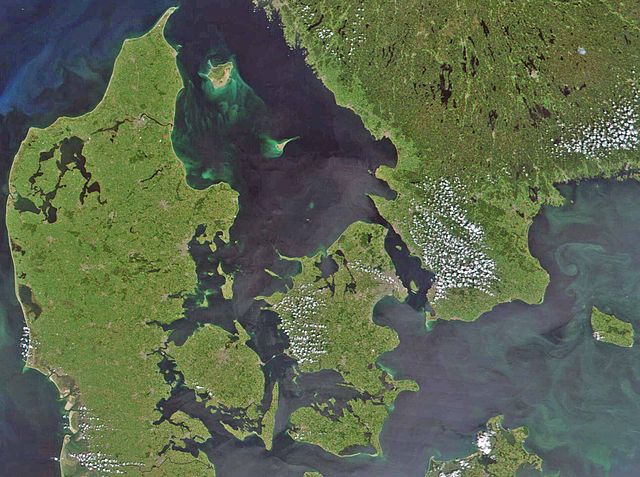
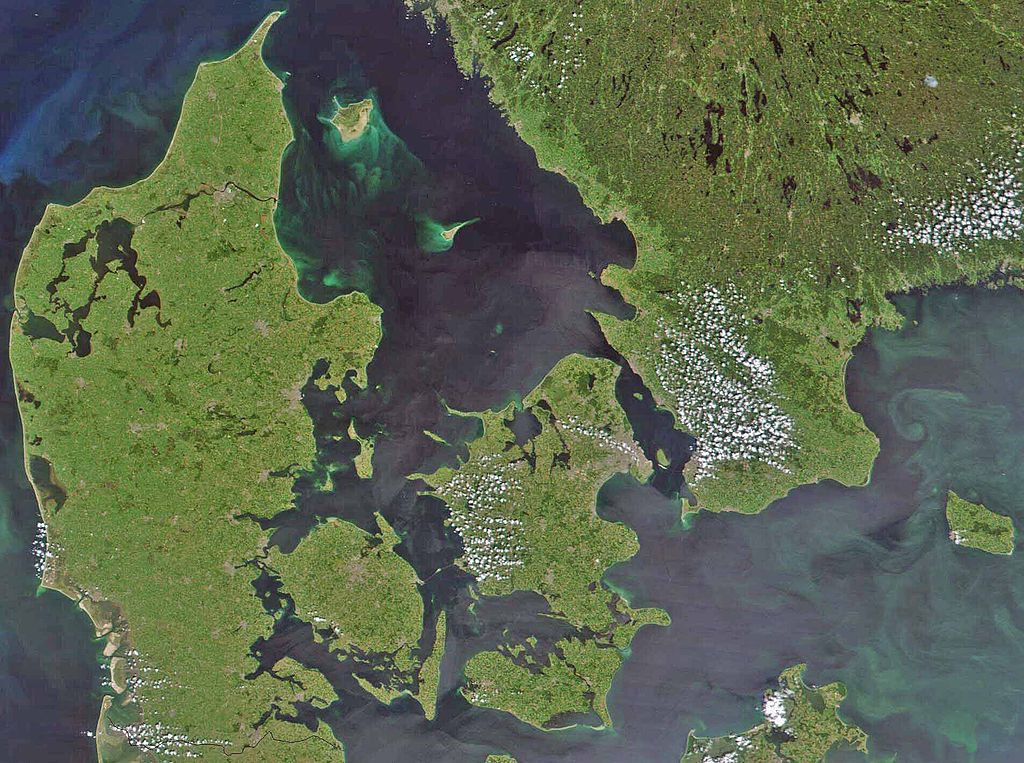
Satellite image of Denmark in July 2001. Cropped image, original taken from NASA's Visible Earth http://visibleearth.nasa.gov/view_rec.php?id=1909
- Interestingly, the Danish-German border is incorrectly placed. The line shown on the map has the correct shape, but is located c. 10 kilometres south of the current border. The line should have been positioned between the islands Rømø and Sylt in the west, and through the fjord to the east. Valentinian (talk) 17:09, 12 November 2006 (UTC)
Fitxategiaren historia
Data/orduan klik egin fitxategiak orduan zuen itxura ikusteko.
| Data/Ordua | Iruditxoa | Neurriak | Erabiltzailea | Iruzkina | |
|---|---|---|---|---|---|
| oraingoa | 10:39, 24 otsaila 2008 | | 1.905 × 1.420 (190 KB) | XcepticZP | Color correction, ligthened up. Smaller file size due to better jpg compression. |
| 16:22, 10 apirila 2005 |  | 1.905 × 1.420 (369 KB) | Hautala | {{PD-USGov-NASA}} Satellite image of Denmark in July 2001. Cropped image, original taken from NASA's Visible Earth http://visibleearth.nasa.gov/view_rec.php?id=1909 |
Irudira dakarten loturak
Hurrengo orrialdeek dute fitxategi honetarako lotura:
Fitxategiaren erabilera orokorra
Hurrengo beste wikiek fitxategi hau darabilte:
- af.wikipedia.org proiektuan duen erabilera
- arz.wikipedia.org proiektuan duen erabilera
- az.wikipedia.org proiektuan duen erabilera
- be.wikipedia.org proiektuan duen erabilera
- bn.wikipedia.org proiektuan duen erabilera
- ca.wikipedia.org proiektuan duen erabilera
- ceb.wikipedia.org proiektuan duen erabilera
- ce.wikipedia.org proiektuan duen erabilera
- cs.wikipedia.org proiektuan duen erabilera
- da.wikipedia.org proiektuan duen erabilera
- Diskussion:København
- Diskussion:Odense
- Diskussion:Hjørring
- Diskussion:Faaborg
- Diskussion:Barneholm
- Svæveflyveklubber i Danmark
- Diskussion:Frederiksberg
- Diskussion:Ærøskøbing
- Diskussion:Frederikssund
- Diskussion:Kalundborg
- Diskussion:Nykøbing Falster
- Skabelon:Klik
- Diskussion:Nivå
- Bruger:Sir48/Sandkasse
- Diskussion:Frederiksværk
- Diskussion:Djævleø
- Diskussion:Frederikshavn
- Diskussion:Lillerød
- Diskussion:Helsingør
- Diskussion:Hørsholm
- Diskussion:Roskilde
- Diskussion:Visborg (by)
- Diskussion:Rønne
- Diskussion:Svendborg
- Diskussion:Slagelse
- Portal:Danmark
- Portal:Danmark/Introtekst
- Diskussion:Næstved
- Diskussion:Fugleholm
- Diskussion:Nexø
- Diskussion:Nakskov
- Diskussion:Allinge-Sandvig
- Diskussion:Sorø
- Diskussion:Rudkøbing
- Diskussion:Lysbro (Silkeborg)
- Skabelondiskussion:Kortpositioner/doc
- Diskussion:Holbæk
- Diskussion:Halsted
Ikus fitxategi honen erabilpen global gehiago.