
Fitxategi:The River Moy at Foxford - geograph.org.uk - 486800.jpg
Ez dago bereizmen handiagorik.
The_River_Moy_at_Foxford_-_geograph.org.uk_-_486800.jpg ((640 × 396 pixel, fitxategiaren tamaina: 104 KB, MIME mota: image/jpeg))
Fitxategi hau Wikimedia Commonsekoa da. Hango deskribapen orriko informazioa behean duzu. |
Laburpena
| Deskribapena |
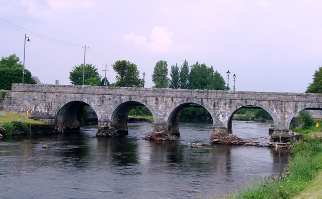
English: The River Moy at Foxford Marks on the pillars of the bridge show the height of the river water before the channel was deepened 40 years ago to alleviate flooding. The water used to cover the bank and path at the bottom right of the picture |
| Data | |
| Jatorria | From geograph.org.uk |
| Egilea | Liz McCabe |
| Aitortu (required by the license) | Liz McCabe / The River Moy at Foxford / |
| Kameraren kokapena | | Irudi hau eta gehiago beraien kokapenekin hurrengo lekuetan: OpenStreetMap |
|---|
_heading:0.00&language=eu)
| Objektuaren kokapena | | Irudi hau eta gehiago beraien kokapenekin hurrengo lekuetan: OpenStreetMap |
|---|
_heading:0.00&language=eu)
Lizentzia

|
This image was taken from the Geograph project collection. See this photograph's page on the Geograph website for the photographer's contact details. The copyright on this image is owned by Liz McCabe and is licensed for reuse under the Creative Commons Attribution-ShareAlike 2.0 license.
|
This file is licensed under the Creative Commons Attribution-Share Alike 2.0 Generic license.
Aitortu: Liz McCabe
- Askea zara:
- partekatzeko – lana kopiatzeko, banatzeko eta bidaltzeko
- birnahasteko – lana moldatzeko
- Ondorengo baldintzen pean:
- eskuduntza – Egiletza behar bezala aitortu behar duzu, lizentzia ikusteko esteka gehitu, eta ea aldaketak egin diren aipatu. Era egokian egin behar duzu hori guztia, baina inola ere ez egileak zure lana edo zure erabilera babesten duela irudikatuz.
- berdin partekatu – Lan honetan oinarrituta edo aldatuta berria eraikitzen baduzu, emaitza lana hau bezalako lizentzia batekin argitaratu behar duzu.
Fitxategiaren historia
Data/orduan klik egin fitxategiak orduan zuen itxura ikusteko.
| Data/Ordua | Iruditxoa | Neurriak | Erabiltzailea | Iruzkina | |
|---|---|---|---|---|---|
| oraingoa | 04:57, 5 otsaila 2011 | | 640 × 396 (104 KB) | GeographBot | == {{int:filedesc}} == {{Information |description={{en|1=The River Moy at Foxford Marks on the pillars of the bridge show the height of the river water before the channel was deepened 40 years ago to alleviate flooding. The water used to cover the bank an |
Irudira dakarten loturak
Ez dago fitxategi hau darabilen orririk.
Fitxategiaren erabilera orokorra
Hurrengo beste wikiek fitxategi hau darabilte:
- cs.wikipedia.org proiektuan duen erabilera
- en.wikipedia.org proiektuan duen erabilera
- fr.wikipedia.org proiektuan duen erabilera
- fy.wikipedia.org proiektuan duen erabilera
- gl.wikipedia.org proiektuan duen erabilera
- uk.wikipedia.org proiektuan duen erabilera