
Fitxategi:Topografic map of Tibetan Plateau.png

Aurreikuspen honen neurria: 800 × 429 pixel. Bestelako bereizmenak: 320 × 172 pixel | 640 × 343 pixel | 1.365 × 732 pixel.
Bereizmen handikoa ((1.365 × 732 pixel, fitxategiaren tamaina: 663 KB, MIME mota: image/png))
Fitxategi hau Wikimedia Commonsekoa da. Hango deskribapen orriko informazioa behean duzu. |
| Deskribapena |
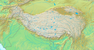
English: Topografic map of the Tibetan Plateau in Asia.
Français : Carte topographique du plateau tibetain.
|
||||
| Data | Data ezezaguna | ||||
| Jatorria | http://www.demis.nl/home/pages/Gallery/examples.htm | ||||
| Egilea | Ezezaguna | ||||
| Lizentzia (Fitxategi hau berrerabiltzen) |
|
Fitxategiaren historia
Data/orduan klik egin fitxategiak orduan zuen itxura ikusteko.
| Data/Ordua | Iruditxoa | Neurriak | Erabiltzailea | Iruzkina | |
|---|---|---|---|---|---|
| oraingoa | 21:51, 26 martxoa 2009 | | 1.365 × 732 (663 KB) | Botev | borders bold, lakes filled in blue |
| 21:02, 2 iraila 2005 |  | 1.365 × 732 (710 KB) | Mats Halldin~commonswiki | Map of Himalaya Bounding box West 66°, South 23°, East 108°, North 42°. {{demis-pd}} category:maps of Himalaya |
Irudira dakarten loturak
Hurrengo orrialdeek dute fitxategi honetarako lotura:
Fitxategiaren erabilera orokorra
Hurrengo beste wikiek fitxategi hau darabilte:
- ar.wikipedia.org proiektuan duen erabilera
- ba.wikipedia.org proiektuan duen erabilera
- be-tarask.wikipedia.org proiektuan duen erabilera
- bn.wikipedia.org proiektuan duen erabilera
- ceb.wikipedia.org proiektuan duen erabilera
- ce.wikipedia.org proiektuan duen erabilera
- da.wikipedia.org proiektuan duen erabilera
- de.wikipedia.org proiektuan duen erabilera
- en.wikipedia.org proiektuan duen erabilera
- Gyachung Kang
- 1950 Assam–Tibet earthquake
- Geladaindong Peak
- Karuo culture
- Haba Snow Mountain
- Anisodus tanguticus
- Outline of Tibet
- Alpine steppe
- Kang Yatze
- Module:Location map/data/Tibetan Plateau/doc
- User:BIO341prj
- 1927 Gulang earthquake
- 1932 Changma earthquake
- Pauhunri
- Guozha Lake
- User:HueSatLum/II
- Singhi Kangri
- Module:Location map/data/Tibetan Plateau
- Gasherbrum VI
- Phrynocephalus vlangalii
- fa.wikipedia.org proiektuan duen erabilera
- fo.wikipedia.org proiektuan duen erabilera
- fr.wikipedia.org proiektuan duen erabilera
- fr.wikibooks.org proiektuan duen erabilera
- gcr.wikipedia.org proiektuan duen erabilera
- hi.wikipedia.org proiektuan duen erabilera
Ikus fitxategi honen erabilpen global gehiago.