
Fitxategi:Trinity-Old-Red-Schoolhouse.jpg
Ez dago bereizmen handiagorik.
Trinity-Old-Red-Schoolhouse.jpg ((770 × 470 pixel, fitxategiaren tamaina: 61 KB, MIME mota: image/jpeg))
Fitxategi hau Wikimedia Commonsekoa da. Hango deskribapen orriko informazioa behean duzu. |
|
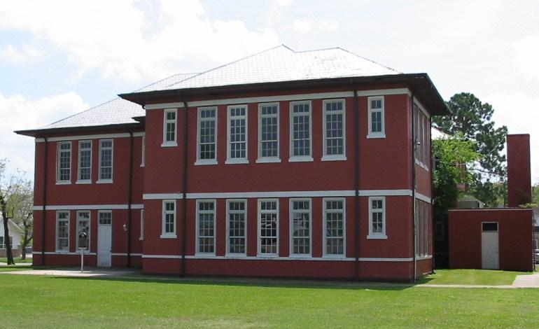
This is an image of a place or building that is listed on the National Register of Historic Places in the United States of America. Its reference number is 5000865. |
Laburpena
| Deskribapena |
English: Old Red Schoolhouse. Trinity's first schoolhouse was a one-room log structure built in 1872 near Cedar Grove Cemetery. A two-story frame schoolhouse that stood on this site from 1897 to 1911 was moved several blocks northwest to serve African American students. Under Supt. J. Woolam Bright, construction of a new brick building began here in 1911, and after many delays it opened by 1915. The Prairie Style, T-Plan building housed all grade levels until completion of an adjacent High School in 1928. "Old Red" served as a schoolhouse for 80 years. When it was slated for demolition in the 1990s, concerned citizens and former students worked with the School District to preserve the historic building for continued use. Recorded Texas Historic Landmark - 2004. Listed in the National Register of Historic Places by the United States Department of the Interior. |
| Data | |
| Jatorria | Own work by uploader Steven Driskell. |
| Egilea | Steven L. Driskell (SDriskell) |
| Objektuaren kokapena | | Irudi hau eta gehiago beraien kokapenekin hurrengo lekuetan: OpenStreetMap |
|---|
Lizentzia
Nik, lan honen egileak, argitaratzen dut ondorengo lizentzia hauen pean:
Fitxategi hau Creative Commons Attribution-Share Alike 3.0 Unported lizentziapean dago.
- Askea zara:
- partekatzeko – lana kopiatzeko, banatzeko eta bidaltzeko
- birnahasteko – lana moldatzeko
- Ondorengo baldintzen pean:
- eskuduntza – Egiletza behar bezala aitortu behar duzu, lizentzia ikusteko esteka gehitu, eta ea aldaketak egin diren aipatu. Era egokian egin behar duzu hori guztia, baina inola ere ez egileak zure lana edo zure erabilera babesten duela irudikatuz.
- berdin partekatu – Lan honetan oinarrituta edo aldatuta berria eraikitzen baduzu, emaitza lana hau bezalako lizentzia batekin argitaratu behar duzu.

|
Baimena duzu dokumentu hau kopiatu, banatu edo/eta aldatzeko GNU Free Documentation License baldintzapean, Free Software Foundationek argitaratutako 1.2 edo ondorengo bertsioan; sekzio aldaezinik gabe, azaleko testurik gabe, eta atzeko azaleko testurik gabe. Lizentziaren kopia dago GNU Free Documentation License izenburudun atalean. |
Nahiago duzun lizentzia erabil dezakezu.
Fitxategiaren historia
Data/orduan klik egin fitxategiak orduan zuen itxura ikusteko.
| Data/Ordua | Iruditxoa | Neurriak | Erabiltzailea | Iruzkina | |
|---|---|---|---|---|---|
| oraingoa | 22:07, 24 martxoa 2009 | | 770 × 470 (61 KB) | SDriskell | {{Information |Description={{en|1=Old Red Schoolhouse. Trinity's first schoolhouse was a one-room log structure built in 1872 near Cedar Grove Cemetery. A two-story frame schoolhouse that stood on this site from 1897 to 1911 was moved several blocks nor |
Irudira dakarten loturak
Hurrengo orrialdeek dute fitxategi honetarako lotura:
Fitxategiaren erabilera orokorra
Hurrengo beste wikiek fitxategi hau darabilte:
- ar.wikipedia.org proiektuan duen erabilera
- arz.wikipedia.org proiektuan duen erabilera
- ceb.wikipedia.org proiektuan duen erabilera
- ce.wikipedia.org proiektuan duen erabilera
- cy.wikipedia.org proiektuan duen erabilera
- de.wikipedia.org proiektuan duen erabilera
- en.wikipedia.org proiektuan duen erabilera
- es.wikipedia.org proiektuan duen erabilera
- ht.wikipedia.org proiektuan duen erabilera
- hu.wikipedia.org proiektuan duen erabilera
- it.wikipedia.org proiektuan duen erabilera
- lld.wikipedia.org proiektuan duen erabilera
- no.wikipedia.org proiektuan duen erabilera
- pl.wikipedia.org proiektuan duen erabilera
- pt.wikipedia.org proiektuan duen erabilera
- sr.wikipedia.org proiektuan duen erabilera
- sv.wikipedia.org proiektuan duen erabilera
- tt.wikipedia.org proiektuan duen erabilera
- uz.wikipedia.org proiektuan duen erabilera
- vi.wikipedia.org proiektuan duen erabilera
- www.wikidata.org proiektuan duen erabilera
- zh-min-nan.wikipedia.org proiektuan duen erabilera