
Fitxategi:Western Aleutians.png

Bereizmen handikoa ((826 × 478 pixel, fitxategiaren tamaina: 10 KB, MIME mota: image/png))
Fitxategi hau Wikimedia Commonsekoa da. Hango deskribapen orriko informazioa behean duzu. |
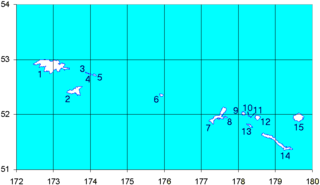
Map of the Western Aleutian Islands. Prepared from Digital Chart of the World (DCW) data. Latitudes are North, longitudes are East. The 52nd parallel is to scale.
1-5 - Near Islands
1 - Attu Island
2 - Agattu Island
3-5 - Semichi Islands
3 - Alaid Island
4 - Nizki Island
5 - Shemya Island
6 - Buldir Island
7-15 Rat Islands
7 - Kiska Island
8 - Little Kiska Island
9 - Segula Island
10 - Khvostof Island
11 - Davidof Island
12 - Little Sitkin Island
13 - Rat Island
14 - Amchitka Island
15 - Semisopochnoi Island
1-5 ニア諸島
1 - アッツ島
2 - アガッツ島
3-5 - セミチ諸島
3 - アライド島
4 - ニズキ島
5 - シェムリャ島
6 - ブルダー島
7-15 ラット諸島
7 - キスカ島
8 - 小キスカ島
9 - セグラ島
10 - クヴォストフ島
11 - ダヴィドフ島
12 - 小スィッキン島
13 - ラット島
14 - アムチトカ島
| Nik, lan honen egile eskubideen jabeak, lan hau domeinu publikoan jartzen dut. Mundu osoan du eragina honek. Estatu batzuetan beharbada hori ez da legez posible izango. Halakoetan: Edonori ematen diot lan hau edozertarako erabiltzeko eskubidea, inolako baldintzarik gabe, legeak nahitaez ezarritako baldintzak izan ezik. |
Fitxategiaren historia
Data/orduan klik egin fitxategiak orduan zuen itxura ikusteko.
| Data/Ordua | Iruditxoa | Neurriak | Erabiltzailea | Iruzkina | |
|---|---|---|---|---|---|
| oraingoa | 17:12, 19 iraila 2008 | | 826 × 478 (10 KB) | Thingg | clarify number 10 and 11 |
| 21:58, 4 abuztua 2005 |  | 826 × 478 (7 KB) | Urhixidur | Map of the Western Aleutian Islands. Prepared from Digital Chart of the World (DCW) data. Latitudes are North, longitudes are East. The 52nd parallel is to scale. 1-5 - Near Islands 1 - Attu Island 2 - Agattu Island 3-5 - Semichi Islands 3 - Alaid Island |
Irudira dakarten loturak
Hurrengo orrialdeek dute fitxategi honetarako lotura:
Fitxategiaren erabilera orokorra
Hurrengo beste wikiek fitxategi hau darabilte:
- arz.wikipedia.org proiektuan duen erabilera
- ast.wikipedia.org proiektuan duen erabilera
- az.wikipedia.org proiektuan duen erabilera
- ca.wikipedia.org proiektuan duen erabilera
- ceb.wikipedia.org proiektuan duen erabilera
- cs.wikipedia.org proiektuan duen erabilera
- de.wikipedia.org proiektuan duen erabilera
- en.wikipedia.org proiektuan duen erabilera
Ikus fitxategi honen erabilpen global gehiago.