
Fitxategi:Yonaguni Island Aerial photograph.2012.jpg

Aurreikuspen honen neurria: 800 × 367 pixel. Bestelako bereizmenak: 320 × 147 pixel | 640 × 293 pixel | 1.024 × 469 pixel | 1.280 × 587 pixel | 2.560 × 1.173 pixel | 6.546 × 3.000 pixel.
Bereizmen handikoa ((6.546 × 3.000 pixel, fitxategiaren tamaina: 14,16 MB, MIME mota: image/jpeg))
Fitxategi hau Wikimedia Commonsekoa da. Hango deskribapen orriko informazioa behean duzu. |
Laburpena
| Deskribapena |
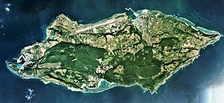
日本語: 与那国島(沖縄県八重山郡与那国町)の空中写真。COK20122-C3-1から同7、同C4-1から同7、同C5-1から同8、同C6-1から同9、同C7-1から同9、同C8-2から同10、同C9-2から同10、同C10-2から同10、同C11-2から同10、同C12-1から同9、同C13-1から同9、同C14-1から同9、同C15-1から同9、同C16-1から同8、同C16-1から同8、同C17-1から同8、同C18-1から同5の合計119枚を合成作成。
English: Yonaguni Island Aerial photograph.2012 |
| Data | |
| Jatorria | 国土情報ウェブマッピングシステム |
| Egilea | 国土地理院 |
Lizentzia

|
The copyright holder of this file, the Ministry of Land, Infrastructure, Transport and Tourism of Japan, allows anyone to use it for any purpose, provided that the copyright holder is properly attributed. Redistribution, derivative work, commercial use, and all other use is permitted. |
Aitortu:
Copyright © National Land Image Information (Color Aerial Photographs), Ministry of Land, Infrastructure, Transport and Tourism
|
 |
This image is copyrighted by the Ministry of Land, Infrastructure, Transport and Tourism of Japan. For terms of use, see the stipulation to use of National Land Information (in Japanese) and message from MLIT (in Japanese and English). When you display this image on an article, include the following phrase in the description: "Made based on National Land Image Information (Color Aerial Photographs), Ministry of Land, Infrastructure, Transport and Tourism".
|
Fitxategiaren historia
Data/orduan klik egin fitxategiak orduan zuen itxura ikusteko.
| Data/Ordua | Iruditxoa | Neurriak | Erabiltzailea | Iruzkina | |
|---|---|---|---|---|---|
| oraingoa | 08:07, 6 azaroa 2020 | | 6.546 × 3.000 (14,16 MB) | さかおり | Uploaded a work by 国土地理院 from 国土情報ウェブマッピングシステム with UploadWizard |
Irudira dakarten loturak
Hurrengo orrialdeek dute fitxategi honetarako lotura:
Fitxategiaren erabilera orokorra
Hurrengo beste wikiek fitxategi hau darabilte:
- fr.wikivoyage.org proiektuan duen erabilera
- he.wikipedia.org proiektuan duen erabilera
- incubator.wikimedia.org proiektuan duen erabilera
- it.wikivoyage.org proiektuan duen erabilera
- ja.wikipedia.org proiektuan duen erabilera
- www.wikidata.org proiektuan duen erabilera
- zh.wikipedia.org proiektuan duen erabilera