Fitxategi:America noviter delineata.jpg
Orriaren edukia ez da onartzen beste hizkuntza batzuetan.
Wikipedia, Entziklopedia askea

Bereizmen handikoa((5.965 × 4.528 pixel, fitxategiaren tamaina: 5,17 MB, MIME mota: image/jpeg))

Fitxategi hau Wikimedia Commonsekoa da. Hango deskribapen orriko informazioa behean duzu.
Commons gordailu bat da, lizentzia askea duten multimedia fitxategiena. Lagun dezakezu.

Fitxategi hau Wikimedia Commonsekoa da

Laburpena

Deskripzio
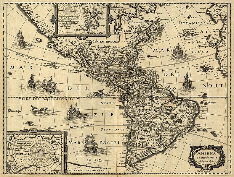
Latina: America noviter delineata / auct. Jodoco Hondio; H. Picard fecit.
English: America newly delineated / by Jodocus Hondius; engraved by H. Picard. A 17th-century map of the Americas. Scale ca. 1:45,000,000. Map ranges from W 125°–W 5° and N 70°–S 60°. Also includes insets of the polar regions.
Français : L'amérique nouvellement cartographiée / Par Jocodus Hondius; gravé par H. Picard. Une carte des amériques du XVIIe siècle. Echelle: environ 1:45 000 000. La carte couvre un espace allant de 5°W à 125°W et de 60°S à 70°N. Elle inclut aussi en encarts les régions polaires.
Jatorria

Published by Jean Boisseau. The U.S. Library of Congress gives the date of publication as "1640?", while another source suggests a first publication of 1637 or 1639. Digital version produced by the U.S. Library of Congress Geography and Map Division. JPEG 2000 source image converted to JPEG by User:Delirium using JasPer 1.701.0, since JPEG 2000 is not as of this uploading supported on Commons.

This map is available from the United States Library of Congress's Geography & Map Division
under the digital ID g3290.np000144.
This tag does not indicate the copyright status of the attached work. A normal copyright tag is still required. See Commons:Licensing.

العربية  беларуская (тарашкевіца)  বাংলা  čeština  Deutsch  English  español  فارسی  suomi  français  galego  עברית  magyar  Bahasa Indonesia  italiano  日本語  lietuvių  македонски  മലയാളം  Nederlands  polski  português  português do Brasil  română  русский  sicilianu  slovenčina  slovenščina  Türkçe  українська  简体中文  繁體中文  +/−

Sortzailea
Jodocus Hondius (1563-1612)
Lizentzia
(Fitxategi hau berrerabiltzen)
Honoko hau, domeinu publikoan dagoen bi dimentsioko artelan baten argazki-erreprodukzio fidela da. Artelana domeinu publikoan dago ondoko arrazoi hauengatik:
Public domain

Lan hau jabetza publikoan dago bai bere jatorrizko herrialdean, bai egile eskubideak egilea hil eta 100 urtera edo gutxiagora iraungitzen diren gainerako herrialdeetan.


You must also include a United States public domain tag to indicate why this work is in the public domain in the United States.
Wikimedia Fundazioak duen jarrera ofiziala hau da:«domeinu publikoan dauden bi dimentsioko erreprodukzio fidelak domeinu publikokoak dira.»
Argazki-erreprodukzio hau, beraz, domeinu publikokotzat hartzen da Estatu Batuetan. Beste jurisdikzio batzuetan eduki honen berrerabilera mugatua egon liteke; xehetasunetarako, ikus Reuse of PD-Art photographs.
Georeferencing Georeference the map in Wikimaps Warper If inappropriate please set warp_status = skip to hide.


Awards

Irudi of the year
Irudi of the year
Irudi of the day
Irudi of the day
Featured irudi

Wikimedia Commons

Fitxategi hau a hautagaia izan da Urteko argazkian 2006.
Fitxategi hau eguneko argazkia izan da: April 17, 2007.
This is a featured picture on Wikimedia Commons (Nabarmendutako irudiak) and is considered one of the finest images.
 With an aspect ratio of 4:3 or 5:4, this image is suitable as a computer wallpaper (see gallery).

If you have an image of similar quality that can be published under a suitable copyright license, be sure to upload it, tag it, and nominate it.

Irudi-oineko testuak

Add a one-line explanation of what this file represents
A 17th-century map of the Americas newly delineated by Jodocus Hondius; engraved by H. Picard.

Fitxategi honetan agertzen diren itemak

honako hau irudikatzen du

media type ingelesa

image/jpeg

checksum ingelesa

5ad48d30d4daf7c752e21a8ff169415effca1831

data size ingelesa

5.422.959 Byte

4.528 pixel

5.965 pixel

Fitxategiaren historia

Data/orduan klik egin fitxategiak orduan zuen itxura ikusteko.

Data/OrduaIruditxoaNeurriakErabiltzaileaIruzkina
oraingoa08:33, 14 ekaina 200608:33, 14 ekaina 2006 bertsioaren iruditxoa5.965 × 4.528 (5,17 MB)Delirium''America noviter delineata / auct. Jodoco Hondio; H. Picard fecit.'' (America newly delineated / by Jodoco Hondia; engraved by H. Picard.) A 17th-century map of the Americas. Scale ca. 1:45,000,000. Map ranges from W 125°–W 5° and N 70&d

Hurrengo orrialdeek dute fitxategi honetarako lotura:

Fitxategiaren erabilera orokorra

Hurrengo beste wikiek fitxategi hau darabilte:

Ikus fitxategi honen erabilpen global gehiago.

Metadatuak