
Fitxategi:1853 Mitchell Map of Turkey in Europe and Greece ( Greece, Balkans, Macedonia ) - Geographicus - TurkeyEurope-mitchell-1850.jpg

Aurreikuspen honen neurria: 489 × 600 pixel. Bestelako bereizmenak: 196 × 240 pixel | 391 × 480 pixel | 626 × 768 pixel | 834 × 1.024 pixel | 2.445 × 3.000 pixel.
Bereizmen handikoa ((2.445 × 3.000 pixel, fitxategiaren tamaina: 2,91 MB, MIME mota: image/jpeg))
Fitxategi hau Wikimedia Commonsekoa da. Hango deskribapen orriko informazioa behean duzu. |
_-_Geographicus_-_TurkeyEurope-mitchell-1850.jpg)
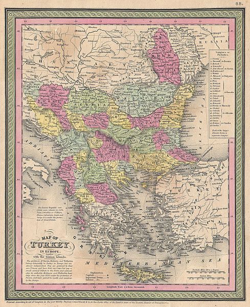
| Samuel Augustus Mitchell: Map of Turkey in Europe together with the Ionian Islands.
( |
||||||||||||||||||||
|---|---|---|---|---|---|---|---|---|---|---|---|---|---|---|---|---|---|---|---|---|
| Artista |
|
|||||||||||||||||||
| Izenburua |
Map of Turkey in Europe together with the Ionian Islands. |
|||||||||||||||||||
| Deskribapena |
English: An extremely attractive example of S. A. Mitchell Sr.’s 1853 map of Turkey in Europe. This map, made when the Ottoman Empire controlled much of the region, covers what is today Turkey, Greece, Macedonia Croatia, Bosnia, Serbia, Romania, Bulgaria, Macedonia and Albania. Ottoman provinces are color coded and numbered. Surrounded by the green border common to Mitchell maps from the 1850s. Prepared by S. A. Mitchell for issued as plate no. 62 in the 1853 edition of his New Universal Atlas . Dated and copyrighted, “Entered according to act of Congress, in the year 1850, by Thomas Cowperthwait & Co., in the Clerks office of the District court of the Eastern District of Pennsylvania. |
|||||||||||||||||||
| Data | 1850 (dated) | |||||||||||||||||||
| Neurriak | altuera: 12,5 in (31,7 cm); Zabalera: 10 in (25,4 cm) | |||||||||||||||||||
| Erregistro-zenbakia |
Geographicus link: TurkeyEurope-mitchell-1850 |
|||||||||||||||||||
| Jatorria/Argazkilaria |
A New Universal Atlas Containing Maps of the various Empires, Kingdoms, States and Republics Of The World. (1853 issue)
|
|||||||||||||||||||
| Lizentzia (Fitxategi hau berrerabiltzen) |
|
|||||||||||||||||||
Fitxategiaren historia
Data/orduan klik egin fitxategiak orduan zuen itxura ikusteko.
| Data/Ordua | Iruditxoa | Neurriak | Erabiltzailea | Iruzkina | |
|---|---|---|---|---|---|
| oraingoa | 15:46, 22 martxoa 2011 | | 2.445 × 3.000 (2,91 MB) | BotMultichillT | {{subst:User:Multichill/Geographicus |link=http://www.geographicus.com/P/AntiqueMap/TurkeyEurope-mitchell-1850 |product_name=1853 Mitchell Map of Turkey in Europe and Greece ( Greece, Balkans, Macedonia ) |map_title=Map of Turkey in Europe together with t |
Irudira dakarten loturak
Ez dago fitxategi hau darabilen orririk.
Fitxategiaren erabilera orokorra
Hurrengo beste wikiek fitxategi hau darabilte:
- sh.wikipedia.org proiektuan duen erabilera
_-_Geographicus_-_TurkeyEurope-mitchell-1850.jpg)