
Fitxategi:1743 Homann Heirs Map of West Africa ( Slave Trade references ) "Guinea" - Geographicus - Aethiopia-hmhr-1743.jpg
Aurreikuspen honen neurria: 702 × 600 pixel. Bestelako bereizmenak: 281 × 240 pixel | 562 × 480 pixel | 899 × 768 pixel | 1.199 × 1.024 pixel | 2.398 × 2.048 pixel | 3.000 × 2.562 pixel.
Bereizmen handikoa ((3.000 × 2.562 pixel, fitxategiaren tamaina: 1,94 MB, MIME mota: image/jpeg))
Fitxategi hau Wikimedia Commonsekoa da. Hango deskribapen orriko informazioa behean duzu. |
_%22Guinea%22_-_Geographicus_-_Aethiopia-hmhr-1743.jpg)
| Guinea Propria, Nec Non Nigritiae Vel Terrae Nigorum…Aethiopia Inferior…1743. | ||||||
|---|---|---|---|---|---|---|
| Artista | ||||||
| Izenburua |
Guinea Propria, Nec Non Nigritiae Vel Terrae Nigorum…Aethiopia Inferior…1743. |
|||||
| Deskribapena |
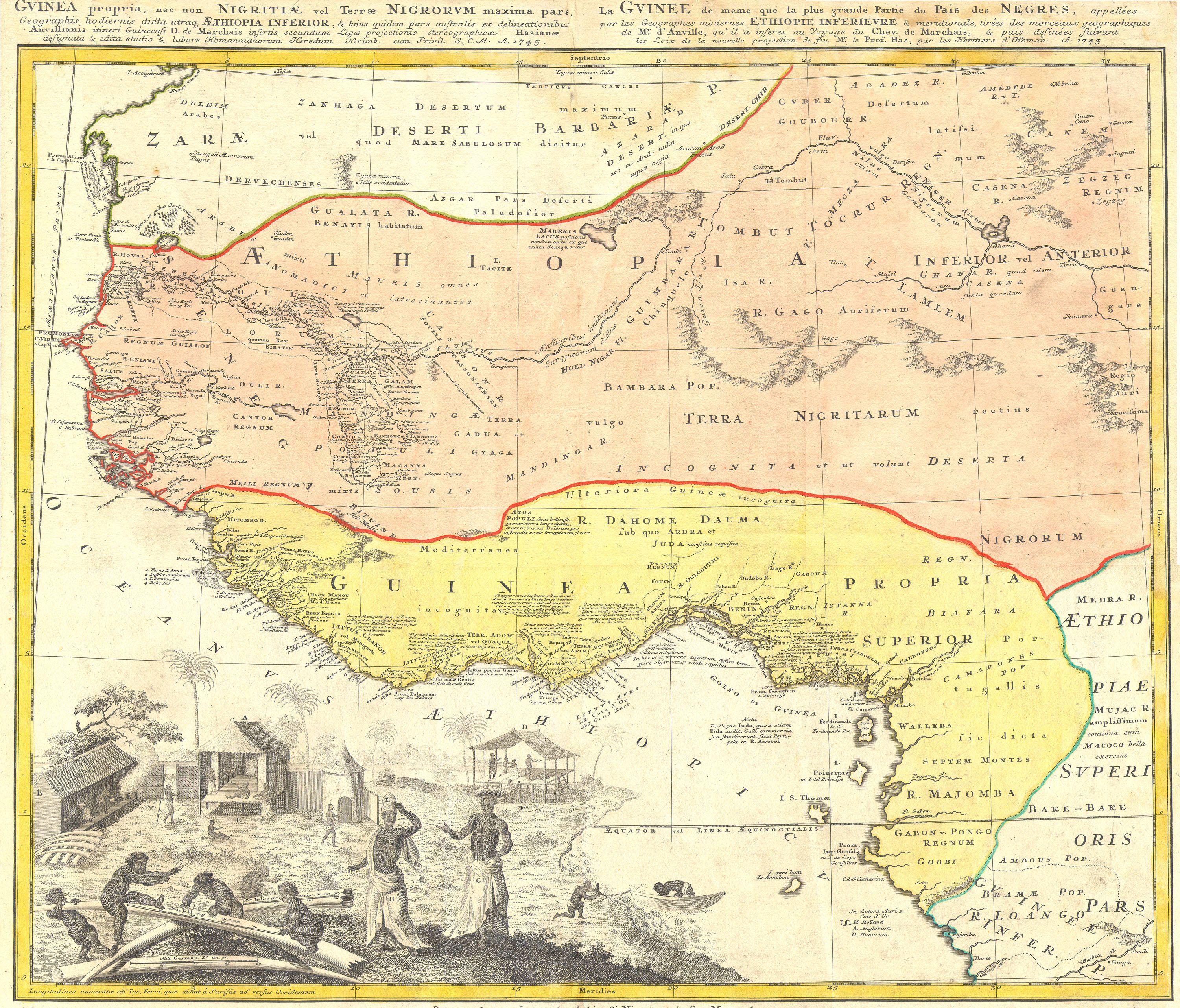
English: One of the finest maps of west Africa to appear in the mid 17th century. Details West Africa from Cape Blanc and Senegal to Guinea Inferior and the Cacongo and Barbela Rivers. Extends inland to including Ghana Lake on the Niger River as far as Regio Auri. The coast is highly detailed with numerous notations in Latin regarding the peoples and tribes of the region. The detail extends inland along some river valleys, most specifically the Niger, however, the map becomes quite vague the farther the river flows inland. Features an elaborate engraving in the lower left depicting ivory, Africa tribespeople and a small village. |
|||||
| Data | 1743 | |||||
| Neurriak | altuera: 19 in (48,2 cm); Zabalera: 23 in (58,4 cm) | |||||
| Erregistro-zenbakia |
Geographicus link: Aethiopia-hmhr-1743 |
|||||
| Jatorria/Argazkilaria |
|
|||||
| Lizentzia (Fitxategi hau berrerabiltzen) |
|
|||||
Fitxategiaren historia
Data/orduan klik egin fitxategiak orduan zuen itxura ikusteko.
| Data/Ordua | Iruditxoa | Neurriak | Erabiltzailea | Iruzkina | |
|---|---|---|---|---|---|
| oraingoa | 13:17, 24 martxoa 2011 | | 3.000 × 2.562 (1,94 MB) | BotMultichillT | {{subst:User:Multichill/Geographicus |link=http://www.geographicus.com/P/AntiqueMap/Aethiopia-hmhr-1743 |product_name=1743 Homann Heirs Map of West Africa ( Slave Trade references ) "Guinea" |map_title=Guinea Propria, Nec Non Nigritiae Vel Terrae Nigorum� |
Irudira dakarten loturak
Hurrengo orrialdeek dute fitxategi honetarako lotura:
Fitxategiaren erabilera orokorra
Hurrengo beste wikiek fitxategi hau darabilte:
- ca.wikipedia.org proiektuan duen erabilera
- en.wikipedia.org proiektuan duen erabilera
- es.wikipedia.org proiektuan duen erabilera
- fi.wikibooks.org proiektuan duen erabilera
- ha.wikipedia.org proiektuan duen erabilera
- he.wikipedia.org proiektuan duen erabilera
- ja.wikipedia.org proiektuan duen erabilera
- sw.wikipedia.org proiektuan duen erabilera
- tr.wikipedia.org proiektuan duen erabilera
_%22Guinea%22_-_Geographicus_-_Aethiopia-hmhr-1743.jpg)