
Fitxategi:Azores satellite photo-NASA.jpg

Aurreikuspen honen neurria: 800 × 600 pixel. Bestelako bereizmenak: 320 × 240 pixel | 640 × 480 pixel | 1.024 × 768 pixel | 1.280 × 960 pixel | 1.600 × 1.200 pixel.
Bereizmen handikoa ((1.600 × 1.200 pixel, fitxategiaren tamaina: 99 KB, MIME mota: image/jpeg))
Fitxategi hau Wikimedia Commonsekoa da. Hango deskribapen orriko informazioa behean duzu. |
Laburpena
| Deskribapena |
Deutsch: Satellitenfoto der Azoren
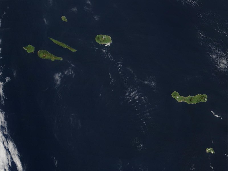
English: Original caption: Hundreds of miles off the coast of Portugal, the nine islands of the Azores chains are stretched out over the Atlantic Ocean. This Moderate Resolution Imaging Spectroradiometer (MODIS) image from the Terra satellite on May 1, 2003, shows seven of the nine islands: (from left to right) Faial, Pico, Sao Jorge, Graciosa (north), Terceira, Sao Miguel, and Santa Maria. |
| Data | |
| Jatorria | visibleearth.nasa.gov (VE Record ID: 25535) |
| Egilea | Jeff Schmaltz, MODIS Rapid Response Team, NASA/GSFC |
| Beste bertsioak | cropped and annotated version: File:Satellite image of The Azores in May 2003.jpg |
Lizentzia
| This file is in the public domain in the United States because it was solely created by NASA. NASA copyright policy states that "NASA material is not protected by copyright unless noted". (See Template:PD-USGov, NASA copyright policy page or JPL Image Use Policy.) | ||
 |
Warnings:
|
Fitxategiaren historia
Data/orduan klik egin fitxategiak orduan zuen itxura ikusteko.
| Data/Ordua | Iruditxoa | Neurriak | Erabiltzailea | Iruzkina | |
|---|---|---|---|---|---|
| oraingoa | 11:28, 20 maiatza 2007 | | 1.600 × 1.200 (99 KB) | Yonidebest | {{Information |Description='''Original caption:''' :''Hundreds of miles off the coast of Portugal, the nine islands of the Azores chains are stretched out over the Atlantic Ocean. This Moderate Resolution Imaging Spectroradiometer (MODIS) image from the T |
Irudira dakarten loturak
Hurrengo orrialdeek dute fitxategi honetarako lotura:
Fitxategiaren erabilera orokorra
Hurrengo beste wikiek fitxategi hau darabilte:
- an.wikipedia.org proiektuan duen erabilera
- ast.wikipedia.org proiektuan duen erabilera
- en.wiktionary.org proiektuan duen erabilera
- eo.wikipedia.org proiektuan duen erabilera
- es.wikipedia.org proiektuan duen erabilera
- gl.wikipedia.org proiektuan duen erabilera
- la.wikipedia.org proiektuan duen erabilera
- lij.wikipedia.org proiektuan duen erabilera
- li.wikipedia.org proiektuan duen erabilera
- mwl.wikipedia.org proiektuan duen erabilera
- nl.wikipedia.org proiektuan duen erabilera
- oc.wikipedia.org proiektuan duen erabilera
- pl.wiktionary.org proiektuan duen erabilera
- pt.wikipedia.org proiektuan duen erabilera
- sv.wikipedia.org proiektuan duen erabilera
- www.wikidata.org proiektuan duen erabilera
- zea.wikipedia.org proiektuan duen erabilera