
Fitxategi:British Decolonisation in Africa.png
Bereizmen handikoa ((2.000 × 2.000 pixel, fitxategiaren tamaina: 406 KB, MIME mota: image/png))
Fitxategi hau Wikimedia Commonsekoa da. Hango deskribapen orriko informazioa behean duzu. |
Laburpena

|
Irudi hau birsortu beharko litzateke SVG irudi bektorial moduan. Honek abantaila asko ematen ditu, ikus Commons:Media for cleanup (ingelesez) informazio gehiagorako. Irudi honen SVG bertsioa eskuragarri badago, mesedez Commonsera igo. Igo ostean, ordezkatu txantiloi hau txantiloi honegatik {{vector version available|irudiaren izen berria.svg}} irudi honetan.
|
| Deskribapena |
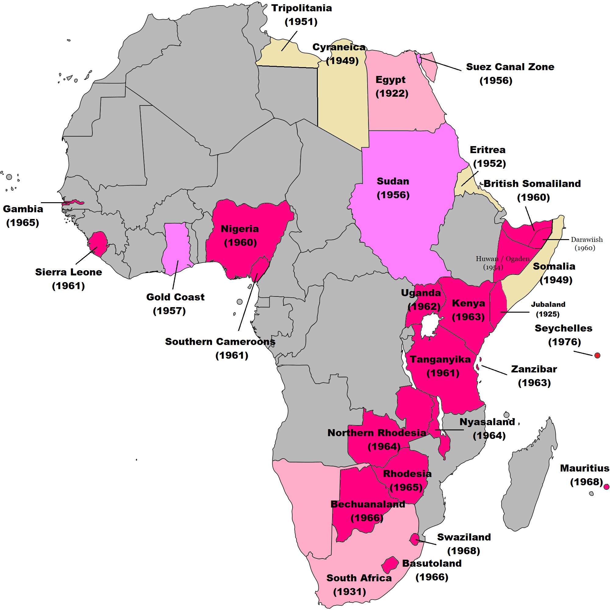
English: Map of British decolonisation in Africa. The beige areas were under British military administration after WW2. The different shades of pink refer to the stages of decolonization according to decades. |
| Data | 2008ko azaroaren 1ea (Jatorrizko igoera-data) |
| Jatorria |
Transferred from en.wikipedia; transfer was stated to be made by User:Hejsa. Blank map from File:BlankMap-World3.svg . Original text:
|
| Egilea | The Red Hat of Pat Ferrick t (log) |
| Lizentzia (Fitxategi hau berrerabiltzen) |
Released into the public domain (by the author). |
Lizentzia
| |
This work has been released into the public domain by its author, The Red Hat of Pat Ferrick, at the ingelesa Wikipedia project. This applies worldwide. In case this is not legally possible: |
Jatorrizko igoera erregistroa
- 2008-11-02 00:56 The Red Hat of Pat Ferrick 757×785× (171674 bytes) {{Information |Description=Map of British decolonisation in Africa. |Source=I created this work entirely by myself. |Date=1 November 2008 |Author=~~~ |other_versions= }}
Fitxategiaren historia
Data/orduan klik egin fitxategiak orduan zuen itxura ikusteko.
| Data/Ordua | Iruditxoa | Neurriak | Erabiltzailea | Iruzkina | |
|---|---|---|---|---|---|
| oraingoa | 10:49, 8 azaroa 2021 | | 2.000 × 2.000 (406 KB) | Randomastwritter | ogaden |
| 05:23, 30 urria 2021 |  | 2.000 × 2.000 (399 KB) | Randomastwritter | juba | |
| 03:38, 7 abendua 2013 |  | 2.000 × 2.000 (396 KB) | Zello | corrected map that better reflects historical realities (for example South-West Africa, Rhodesia), also Mauritius and Seychelle added, and new colour for territories under temporary military administration after WW2 | |
| 20:52, 22 azaroa 2013 |  | 757 × 785 (159 KB) | Zello | Somalia became a UN Trust Territory under Italian administration in 1949. The correction was requested also on the talk page. | |
| 18:08, 13 iraila 2009 |  | 757 × 785 (168 KB) | Hejsa | {{Information |Description={{en|Map of British decolonisation in Africa.}} |Source=Transferred from [http://en.wikipedia.org en.wikipedia]; transfer was stated to be made by User:Hejsa. |Date=1 November 2008<br/> ({{Date|2008|11|02}} (original upload |
Irudira dakarten loturak
Hurrengo orrialdeek dute fitxategi honetarako lotura:
Fitxategiaren erabilera orokorra
Hurrengo beste wikiek fitxategi hau darabilte:
- ar.wikipedia.org proiektuan duen erabilera
- ast.wikipedia.org proiektuan duen erabilera
- azb.wikipedia.org proiektuan duen erabilera
- az.wikipedia.org proiektuan duen erabilera
- ba.wikipedia.org proiektuan duen erabilera
- cs.wikipedia.org proiektuan duen erabilera
- da.wikipedia.org proiektuan duen erabilera
- de.wikipedia.org proiektuan duen erabilera
- el.wikipedia.org proiektuan duen erabilera
- en.wikipedia.org proiektuan duen erabilera
- fr.wikipedia.org proiektuan duen erabilera
- fr.wikiversity.org proiektuan duen erabilera
- hy.wikipedia.org proiektuan duen erabilera
- id.wikipedia.org proiektuan duen erabilera
- it.wikipedia.org proiektuan duen erabilera
- ka.wikipedia.org proiektuan duen erabilera
- ko.wikipedia.org proiektuan duen erabilera
- lv.wikipedia.org proiektuan duen erabilera
- ms.wikipedia.org proiektuan duen erabilera
- nl.wikipedia.org proiektuan duen erabilera
- no.wikipedia.org proiektuan duen erabilera
- pl.wikipedia.org proiektuan duen erabilera
- pt.wikipedia.org proiektuan duen erabilera
- ru.wikipedia.org proiektuan duen erabilera
- th.wikipedia.org proiektuan duen erabilera
- tr.wikipedia.org proiektuan duen erabilera
- uk.wikipedia.org proiektuan duen erabilera
Ikus fitxategi honen erabilpen global gehiago.