
Fitxategi:China county-level divisions and administrative divisions (PRoC claim).png

Aurreikuspen honen neurria: 759 × 600 pixel. Bestelako bereizmenak: 304 × 240 pixel | 607 × 480 pixel | 972 × 768 pixel | 1.280 × 1.012 pixel | 2.560 × 2.023 pixel | 6.246 × 4.937 pixel.
Bereizmen handikoa ((6.246 × 4.937 pixel, fitxategiaren tamaina: 1,54 MB, MIME mota: image/png))
Fitxategi hau Wikimedia Commonsekoa da. Hango deskribapen orriko informazioa behean duzu. |

.png)

|
This image is expected to always be the most recent one. Feel free to update it when needed.
|

|
This file may be updated to reflect new information. If you wish to use a specific version of the file without new updates being mirrored, please upload the required version as a separate file. |
Laburpena
| Deskribapena |
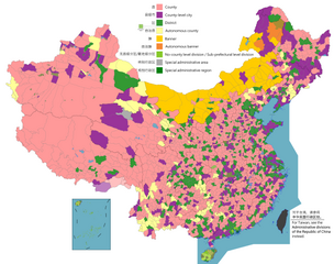
English: Map of China, shows counties, county-level cities, county-level districts, autonomous counties and banners, banners, etc.
日本語: 中国の地図は、郡、郡レベルの都市、郡レベルの地区、自治県とバナー、バナーなどを示しています。
Русский: Карта Китая, показывает уезды, города уездного уровня, уездные районы, автономные уезды и баннеры, баннеры и т. Д.
中文(简体):中国地图,显示县、县级市、县级区、自治县和旗、自治旗等。
中文(繁體):中國地圖,顯示縣、縣級市、縣級區、自治縣和旗、自治旗等。 |
||
| Data |
|
||
| Jatorria |
Legend: English:
County
County-level city
County-level district
Autonomous county
Banner
Autonomous banner
No county-level division / Sub-prefectural level division
Special district
Special administrative region 中文(简体): 县
县级市
县级区
自治县
旗
自治旗
无县级/副地级
特区
特别行政区 |
||
| Egilea |
|
||
| Lizentzia (Fitxategi hau berrerabiltzen) |
Map of China, administrative divisions: Nik, lan honen egileak, argitaratzen dut ondorengo lizentzia pean:
|
Lizentzia
Nik, lan honen egileak, argitaratzen dut ondorengo lizentzia pean:
This file is licensed under the Creative Commons Attribution-Share Alike 4.0 International license.
- Askea zara:
- partekatzeko – lana kopiatzeko, banatzeko eta bidaltzeko
- birnahasteko – lana moldatzeko
- Ondorengo baldintzen pean:
- eskuduntza – Egiletza behar bezala aitortu behar duzu, lizentzia ikusteko esteka gehitu, eta ea aldaketak egin diren aipatu. Era egokian egin behar duzu hori guztia, baina inola ere ez egileak zure lana edo zure erabilera babesten duela irudikatuz.
- berdin partekatu – Lan honetan oinarrituta edo aldatuta berria eraikitzen baduzu, emaitza lana hau bezalako lizentzia batekin argitaratu behar duzu.

|
Irudi hau birsortu beharko litzateke SVG irudi bektorial moduan. Honek abantaila asko ematen ditu, ikus Commons:Media for cleanup (ingelesez) informazio gehiagorako. Irudi honen SVG bertsioa eskuragarri badago, mesedez Commonsera igo. Igo ostean, ordezkatu txantiloi hau txantiloi honegatik {{vector version available|irudiaren izen berria.svg}} irudi honetan.
|
| Annotations | This image is annotated: View the annotations at Commons |
Fitxategiaren historia
Data/orduan klik egin fitxategiak orduan zuen itxura ikusteko.
.png&dir=prev)
.png&offset=20220329005936)
.png&offset=&limit=20)
.png&offset=&limit=50)
.png&offset=&limit=100)
.png&offset=&limit=250)
.png&offset=&limit=500)
| Data/Ordua | Iruditxoa | Neurriak | Erabiltzailea | Iruzkina | |
|---|---|---|---|---|---|
| oraingoa | 10:59, 1 abuztua 2023 | | 6.246 × 4.937 (1,54 MB) | Maanshen | Add Baiyang, update and fix Nanchang borders |
| 10:32, 1 abuztua 2023 |  | 6.246 × 4.937 (1,54 MB) | Maanshen | Update: Tsona County -> Tsona City, Mainling County -> Mainling City | |
| 14:30, 31 uztaila 2023 |  | 6.246 × 4.937 (1,41 MB) | Baomi | ||
| 18:35, 16 uztaila 2023 |  | 6.246 × 4.937 (1,59 MB) | Josemite | That old nine-dashed line is badly drawn | |
| 11:52, 17 otsaila 2023 |  | 6.246 × 4.937 (1,55 MB) | 孟天皓 | 修改香港区界 | |
| 01:06, 3 abuztua 2022 |  | 6.246 × 4.937 (1,55 MB) | Maanshen | Update disputed/claimed borders, white with stroke is not claimed and filled in color is claimed | |
| 02:08, 20 apirila 2022 |  | 6.246 × 4.937 (1,54 MB) | Maanshen | Fix borders between Ili's Kuytun, Huyanghe, and Karamay | |
| 01:41, 20 apirila 2022 |  | 6.246 × 4.937 (1,54 MB) | Maanshen | Fix colors again in Honghe counties | |
| 03:45, 31 martxoa 2022 |  | 6.246 × 4.937 (1,54 MB) | Maanshen | Fix some colors | |
| 02:59, 29 martxoa 2022 |  | 6.246 × 4.937 (1,54 MB) | Maanshen | Fix colors in Shanxi with Fenyang and Xiaoyi |
Irudira dakarten loturak
Ez dago fitxategi hau darabilen orririk.
Fitxategiaren erabilera orokorra
Hurrengo beste wikiek fitxategi hau darabilte:
- ar.wikipedia.org proiektuan duen erabilera
- ast.wikipedia.org proiektuan duen erabilera
- az.wikipedia.org proiektuan duen erabilera
- ca.wikipedia.org proiektuan duen erabilera
- ce.wikipedia.org proiektuan duen erabilera
- cs.wikipedia.org proiektuan duen erabilera
- de.wikipedia.org proiektuan duen erabilera
- en.wikipedia.org proiektuan duen erabilera
- es.wikipedia.org proiektuan duen erabilera
- fa.wikipedia.org proiektuan duen erabilera
- fi.wikipedia.org proiektuan duen erabilera
- fr.wikipedia.org proiektuan duen erabilera
- id.wikipedia.org proiektuan duen erabilera
- ja.wikipedia.org proiektuan duen erabilera
- mk.wikipedia.org proiektuan duen erabilera
- nl.wikipedia.org proiektuan duen erabilera
- no.wikipedia.org proiektuan duen erabilera
- pnb.wikipedia.org proiektuan duen erabilera
- ru.wikipedia.org proiektuan duen erabilera
- sv.wikipedia.org proiektuan duen erabilera
- th.wikipedia.org proiektuan duen erabilera
- tr.wikipedia.org proiektuan duen erabilera
- uk.wikipedia.org proiektuan duen erabilera
- ur.wikipedia.org proiektuan duen erabilera
- vi.wikipedia.org proiektuan duen erabilera
- www.wikidata.org proiektuan duen erabilera
- zh.wikipedia.org proiektuan duen erabilera
Ikus fitxategi honen erabilpen global gehiago.
.png)
.png)