
Fitxategi:China prefectural-level divisions and administrative divisions (PRoC claim).png

Aurreikuspen honen neurria: 759 × 600 pixel. Bestelako bereizmenak: 304 × 240 pixel | 607 × 480 pixel | 972 × 768 pixel | 1.280 × 1.012 pixel | 2.560 × 2.023 pixel | 6.246 × 4.937 pixel.
Bereizmen handikoa ((6.246 × 4.937 pixel, fitxategiaren tamaina: 987 KB, MIME mota: image/png))
Fitxategi hau Wikimedia Commonsekoa da. Hango deskribapen orriko informazioa behean duzu. |


|
The boundaries on this map show the de facto situation. This is just one of several different views on the subject (see COM:NPOV). |

|
This image is expected to always be the most recent one. Feel free to update it when needed.
|

|
This file may be updated to reflect new information. If you wish to use a specific version of the file without new updates being mirrored, please upload the required version as a separate file. |
Laburpena
| Deskripzio |
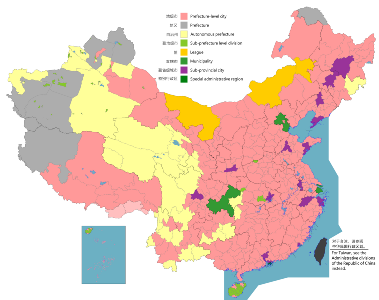
English: Map of China, shows provinces, prefecture-level divisions, etc.
日本語: 中国の地図、州、県レベルの区分などを示しています。
Русский: Карта Китая, показывает провинции, подразделения на уровне префектур и т. Д.
Монгол: Хятад улсын газрын зураг, мужууд, мужийн түвшний хэлтэс гэх мэтийг харуулсан.
中文(简体):中华人民共和国地图,显示省、地级区划等。(包含未实际控制之疆域)
中文(繁體):中華人民共和國地圖,顯示省、地級區劃等。 (包含未實際控制之疆域) |
||
| Map legend |
English:
Prefecture-level city
Prefecture
Autonomous prefecture
Sub prefecture-level division
League
Municipality
Sub-provincial city
Special administrative region 图例: 中文(简体):
地级市
地区
自治州
副地级市
盟
直辖市
副省级市
特别行政区 圖例: 中文(繁體): 地級市
地區
自治州
副地級市
盟
直轄市
副省級市
特別行政區 |
||
| Data |
English: File uploaded: November 6, 2021
English: Original uploaded: September 12, 2011
Latest update: 07:09, 17 November 2023 中文(简体):原始上传时间2011年9月12日
中文(繁體):文件上传时间2021年11月6日
中文(繁體):原始上傳時間2011年9月12日 |
||
| Jatorria |
English: Source appearances: 中文(简体):来源于: 中文(繁體):來源於:
[]
|
||
| Sortzailea |
|
||
| Lizentzia (Fitxategi hau berrerabiltzen) |
English: Map of China, administrative divisions: 中文(简体):中国地图,行政区划 中文(繁體):中國地圖,行政區劃 Nik, lan honen egileak, argitaratzen dut ondorengo lizentzia pean:
|
||
| Geotemporal data | |||
| Date depicted | as of February 4, 2021 | ||
| Spatial reference system | Custom | ||
| Georeferencing | |||
| Beste bertsioak |
English: Other languages: 中文(简体):其他语言: 中文(繁體):其他語言:
[]
Derivative works on these files: |
||


.png)
_sl.png)
.png)
Lizentzia
Nik, lan honen egileak, argitaratzen dut ondorengo lizentzia pean:
This file is licensed under the Creative Commons Attribution-Share Alike 4.0 International license.
- Askea zara:
- partekatzeko – lana kopiatzeko, banatzeko eta bidaltzeko
- birnahasteko – lana moldatzeko
- Ondorengo baldintzen pean:
- eskuduntza – Egiletza behar bezala aitortu behar duzu, lizentzia ikusteko esteka gehitu, eta ea aldaketak egin diren aipatu. Era egokian egin behar duzu hori guztia, baina inola ere ez egileak zure lana edo zure erabilera babesten duela irudikatuz.
- berdin partekatu – Lan honetan oinarrituta edo aldatuta berria eraikitzen baduzu, emaitza lana hau bezalako lizentzia batekin argitaratu behar duzu.

|
Irudi hau birsortu beharko litzateke SVG irudi bektorial moduan. Honek abantaila asko ematen ditu, ikus Commons:Media for cleanup (ingelesez) informazio gehiagorako. Irudi honen SVG bertsioa eskuragarri badago, mesedez Commonsera igo. Igo ostean, ordezkatu txantiloi hau txantiloi honegatik {{vector version available|irudiaren izen berria.svg}} irudi honetan.
|
|
|
Irudi hau birsortu beharko litzateke SVG irudi bektorial moduan. Honek abantaila asko ematen ditu, ikus Commons:Media for cleanup (ingelesez) informazio gehiagorako. Irudi honen SVG bertsioa eskuragarri badago, mesedez Commonsera igo. Igo ostean, ordezkatu txantiloi hau txantiloi honegatik {{vector version available|irudiaren izen berria.svg}} irudi honetan.
|
| Annotations | This image is annotated: View the annotations at Commons |
Fitxategiaren historia
Data/orduan klik egin fitxategiak orduan zuen itxura ikusteko.
.png&dir=prev)
.png&offset=20220128000854)
.png&offset=&limit=20)
.png&offset=&limit=50)
.png&offset=&limit=100)
.png&offset=&limit=250)
.png&offset=&limit=500)
| Data/Ordua | Iruditxoa | Neurriak | Erabiltzailea | Iruzkina | |
|---|---|---|---|---|---|
| oraingoa | 04:26, 11 abuztua 2023 | | 6.246 × 4.937 (987 KB) | Vikarna | 州→地区 & 副地级划分→副地级市 |
| 10:59, 1 abuztua 2023 |  | 6.246 × 4.937 (987 KB) | Maanshen | Add Baiyang county-level city | |
| 11:50, 1 abendua 2022 |  | 6.246 × 4.937 (987 KB) | Maanshen | Re-added disputed borders from the third version and removed the nine-dash line to prevent future bans to maps | |
| 07:28, 23 azaroa 2022 |  | 6.246 × 4.937 (951 KB) | Vikarna | municipality 市政府→直辖市 | |
| 07:10, 23 azaroa 2022 |  | 6.246 × 4.937 (986 KB) | Vikarna | League 联盟→盟 | |
| 01:06, 3 abuztua 2022 |  | 6.246 × 4.937 (992 KB) | Maanshen | Update disputed/claimed borders, white with stroke is not claimed and filled in color is claimed | |
| 02:08, 20 apirila 2022 |  | 6.246 × 4.937 (975 KB) | Maanshen | Fix borders between Ili's Kuytun, Huyanghe, and Karamay | |
| 05:51, 1 martxoa 2022 |  | 6.246 × 4.937 (975 KB) | Maanshen | Update Shanghai land reclamation | |
| 10:26, 28 urtarrila 2022 |  | 6.246 × 4.937 (975 KB) | Maanshen | Fix Changchun-Siping border | |
| 02:08, 28 urtarrila 2022 |  | 6.246 × 4.937 (975 KB) | Maanshen | Add parts of Tiemenguan |
Irudira dakarten loturak
Ez dago fitxategi hau darabilen orririk.
Fitxategiaren erabilera orokorra
Hurrengo beste wikiek fitxategi hau darabilte:
- ast.wikipedia.org proiektuan duen erabilera
- bg.wikipedia.org proiektuan duen erabilera
- cs.wikipedia.org proiektuan duen erabilera
- en.wikipedia.org proiektuan duen erabilera
- es.wikipedia.org proiektuan duen erabilera
- fa.wikipedia.org proiektuan duen erabilera
- fi.wikipedia.org proiektuan duen erabilera
- fr.wikipedia.org proiektuan duen erabilera
- hu.wiktionary.org proiektuan duen erabilera
- id.wikipedia.org proiektuan duen erabilera
- incubator.wikimedia.org proiektuan duen erabilera
- ja.wikipedia.org proiektuan duen erabilera
- pt.wikipedia.org proiektuan duen erabilera
- ru.wikipedia.org proiektuan duen erabilera
- sh.wikipedia.org proiektuan duen erabilera
- si.wikipedia.org proiektuan duen erabilera
- sv.wikipedia.org proiektuan duen erabilera
- th.wikipedia.org proiektuan duen erabilera
- tr.wikipedia.org proiektuan duen erabilera
- ur.wikipedia.org proiektuan duen erabilera
- vi.wikipedia.org proiektuan duen erabilera
- www.wikidata.org proiektuan duen erabilera
- wuu.wikipedia.org proiektuan duen erabilera
- zh-yue.wikipedia.org proiektuan duen erabilera
- zh.wikipedia.org proiektuan duen erabilera
Ikus fitxategi honen erabilpen global gehiago.
.png)
.png)